This item has been sold, but you can get on the Waitlist to be notified if another example becomes available, or purchase a digital scan.
1850 Levasseur Map of Ile de La Reunion
Reunion-levasseur-1850$85.00

Title
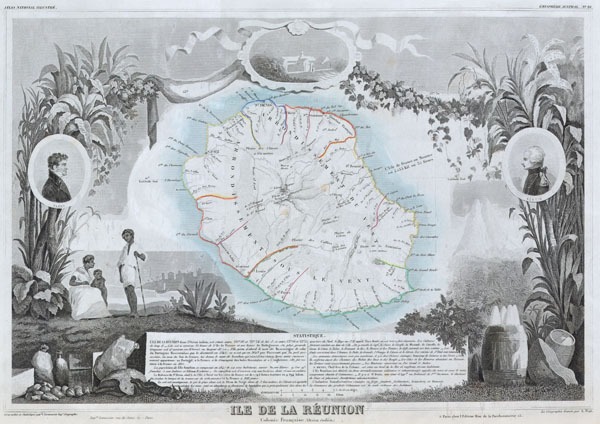
Ile de La Reunion Colonie Francaise (ocean indien)
1850 12.5 x 17.5 in (31.75 x 44.45 cm)
1850 12.5 x 17.5 in (31.75 x 44.45 cm)
Description
This is a fascinating 1850 map of the French island colony of Reunion in the Indian Ocean, off the coast of Madagascar. Depicts the island in moderate detail with both political and geographical indications. The whole is surrounded by elaborate decorative engravings designed to illustrate both the natural beauty and trade richness of the island. There is a short textual history of the island included at the bottom of the map. Today the beautiful Island of Reunion is a popular tourist destination.
Cartographer
Victor Levasseur (1800 - 1870), an important French engineer, cartographer, and engraver of the mid 19th century, held a number of important cartographically related political and educations posts in France. He is most famous for his Atlas National Illustré des 86 Départements et des Possessions de La France, a large decorative atlas of France, including his Planisphere and five important continental maps. Levasseur's maps are distinctive for their wide decorative margins containing elaborate depictions of the scenery, peoples, and trade goods of the areas he mapped. Levasseur maps are also known to offer a wealth of statistical data. Until recently, very few Levasseur Atlases migrated out of France where they were mostly used in public libraries and town halls. His work represents some of the last great decorative atlases of the 19th century. More by this mapmaker...
Condition
Fine or Perfect condition. Wide clean margins. Blank on verso.