This item has been sold, but you can get on the Waitlist to be notified if another example becomes available, or purchase a digital scan.
1800 Depot de la Marine Nautical Chart or Map of the Rio de la Plata (Argentina, Buenos Aires, Monte
RiodelaPlata-depotdemarine-1800$550.00

Title
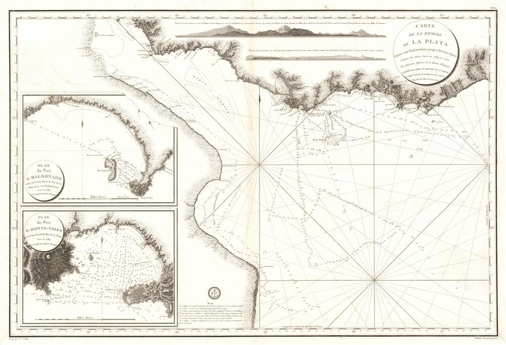
Carte de La Riviere de La Plata depuis son Embouchure jusqu'a Buenos-Ayres d'apres les Plans leves en 1789 et 1794.
1800 (dated) 24.5 x 35.5 in (62.23 x 90.17 cm) 1 : 648000
1800 (dated) 24.5 x 35.5 in (62.23 x 90.17 cm) 1 : 648000
Description
This is an extremely scarce large format c. 1800 French nautical chart or maritime map of the Rio de la Plata, Argentina and Uruguay. The chart is noteworthy for the extraordinary engraving mastery it exhibits - a hallmark of the engraver Charles-Étienne Collin (1770 - 1840). This elegantly presented map covers the entire estuary from Los Cerros de San Juan to the Laguna de Rocha and extends south to approximately 55 degrees south latitude. The chart includes the important ports of Buenos Aires, Sacramento, Montevideo, and Maldonado, among others. The detail is primarily coastal, extending only about 10 miles inland, but the terrestrial detail offered throughout, including topography rendered in hachure, is extraordinary. Nautically, the map offers a multitude of soundings and outlines several shoals. Two large inset maps offer extraordinary detail focused on the ports of Maldonado and Montevideo, both in modern-day Uruguay. Shore profiles line the top of the map.
The Map's Hydrography and the Malaspina Expedition
The hydrography for this map is credited to Spanish marine surveys accomplished between 1789 and 1794. Although not specifically noted, this can only refer to the Malaspina Expedition undertaken during this same period. The expedition was jointly led by Alessandro Malaspina and José de Bustamante y Guerra. Theoretically, the Malaspina Expedition, which was sponsored by the Spanish government, was a purely scientific endeavor in the spirit of Cook or La Perouse, but Malaspina quickly became involved in local politics and later attempted to overthrow the government in order to liberate the colonies - an act for which he was subsequently arrested. Nonetheless, the scientific accomplishments of the mission were substantial despite being largely suppressed by the Spanish government in light of Malaspina's treason. In the course of the voyage Malaspina visited the Rio de la Plata twice, on his outbound route in 1789 and again on his return in 1794. Both visits resulted in the new survey information that was incorporated into a very similar Spanish Deposito Hydrografico carta esferica issued in 1798, from which Malaspina's name is notable omitted.A Landmark French Chart Inspired by a Landmark Spanish Chart
The 1789 carta esferica is clearly the basis for this French chart issued just two years later. Although seemingly sparse, the precision and hydrographic detail presented throughout redefined the cartographic perspective on the region and represents a significant advancement over 18th century charts issued by Nicholas Bellin and others.Publication History and Census
The map is dated in the title cartouche according to the French Republican Calendar, 'L'An IX de l'Ere Francaise' or the 'the 9th year of the French Era'. This corresponds to 1800. The French Republican Calendar was intended to remove religious and royalist influences and was popular between 1703 and 1805, when it was formally abolished. It was engraved by Charles-Étienne Collin (1770 - 1840), a contract engraver under Philippe Buache the Dépôt de la Marine. An example is cataloged in OCLC and is part of the institutional collection at the Bibliothèque nationale de France.CartographerS
Dépôt des Cartes et Plans de la Marine (fl. 1720 - present), often called the Dépôt de Marine, was a French hydrographic mapping organization founded in 1720 under Charles-Hercule of Albert de Luynes (1674 - 1734). Much like the U.S. Coast Survey, the British Admiralty, and the Spanish Deposito Hydrografico, the Dépôt was initiated as a storehouse and distribution center of existing nautical and marine charts. Eventually the Dépôt initiated its own mapping activities in an attempt to improve and expand upon existing material. Some of the more prominent cartographers and hydrographers associated with the of Dépôt des Cartes were, Philippe Buache, Jacques-Nicholas Bellin, Giovanni Rizzi-Zannoni, Rigobert Bonne, and Jean Nicolas Buache. More by this mapmaker...
Charles-Étienne Collin (1770 - 1840) was a French engraver active in Paris during the late 18th and early 19th centuries. Collin was born in Paris to a long line of important French engravers dating back to Jean Collin. He was the son of Bernard Collin (1737 - 1791), son of Jean. Collin engraved for the seminal 1809 - 1822 Description de l'Egypte and extensively for the Dépôt de la Marine. His was contracted by his cousin by marriage, Phillipe Buache (February 7, 1700 - January 24, 1773) for his exceptional engraving mastery to work for the Dépôt de la Marine from at least August 1793. He worked with his brother, Jean-Louis Collin (1775 - 1858), from 1800 to 1803. His son, also Charles-Étienne Collin or possibly just Étienne Collin II (1790 - 1852), apprenticed under him and worked with him from 1821 to 1829. Under Charles-Étienne Collin (1770 - 1840) and then his son, the firm was located in Paris at N° 45, Rue de la Harpe. The last known work attributed to 'E. Collin' appeared in 1831. Distinguishing between the 'Collin' family of engravers on Dépôt de la Marine is difficult. The elder Étienne Collin (1770 - 1840) typically signed his work 'E. Collin' or later 'E. Collin père'. His son signs some of his work as 'E. Collin' and others as 'C.E. Collin fils.' There is some evidence of another generation of Collin engravers, also Charles-Étienne Collin, signing his work as 'C. E. Collin' between 1840 and 1875. Learn More...
Condition
Very good. Minor wear on original centerfold.
References
OCLC 904488959.