1757 Bellin Map of Rio de la Plata
RiviereDeLaPlata-bellin-1757$175.00

Title
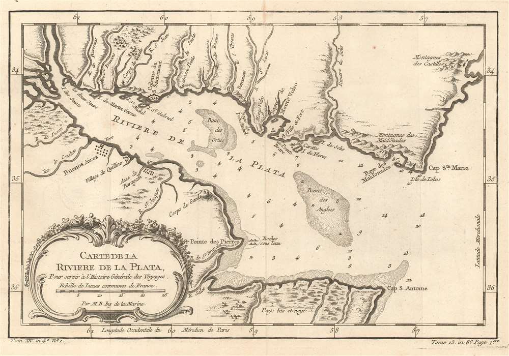
Carte De La Riviere De La Plata : Pour servir à l'Histoire Générale des Voyages.
1757 (undated) 7 x 11.5 in (17.78 x 29.21 cm) 1 : 1798160
1757 (undated) 7 x 11.5 in (17.78 x 29.21 cm) 1 : 1798160
Description
This is a 1757 Jacques-Nicolas Bellin map of the Canary Islands. The map depicts the Rio de la Plata as it empties into the Atlantic Ocean, with modern-day Uruguay on the top and Argentina on the bottom. Today, the Rio de la Plata forms part of the border between Argentina and Uruguay, with both Buenos Aires and Montevideo situated along its banks. Both Buenos Aires (Buenos Ayres) and Montevideo are labeled here, along with the Baye van Montvidio, which is noted as a safe harbor. Small villages and other settlements are also labeled. Numerous smaller rivers are illustrated emptying into the Rio de la Plata from both banks and many of them are identified. Depth soundings are included along both banks and within the Rio de la Plata, along with two banks.
Publication History
This map was created by Jacques-Nicolas Bellin for publication in Abbé Prévost's Histoire Générale des Voyages.Cartographer
Jacques-Nicolas Bellin (1703 - March 21, 1772) was one of the most important cartographers of the 18th century. With a career spanning some 50 years, Bellin is best understood as geographe de cabinet and transitional mapmaker spanning the gap between 18th and early-19th century cartographic styles. His long career as Hydrographer and Ingénieur Hydrographe at the French Dépôt des cartes et plans de la Marine resulted in hundreds of high quality nautical charts of practically everywhere in the world. A true child of the Enlightenment Era, Bellin's work focuses on function and accuracy tending in the process to be less decorative than the earlier 17th and 18th century cartographic work. Unlike many of his contemporaries, Bellin was always careful to cite his references and his scholarly corpus consists of over 1400 articles on geography prepared for Diderot's Encyclopedie. Bellin, despite his extraordinary success, may not have enjoyed his work, which is described as "long, unpleasant, and hard." In addition to numerous maps and charts published during his lifetime, many of Bellin's maps were updated (or not) and published posthumously. He was succeeded as Ingénieur Hydrographe by his student, also a prolific and influential cartographer, Rigobert Bonne. More by this mapmaker...
Condition
Very good. Even overall toning. Light wear along original fold lines. Light transference. Blank on verso.
References
OCLC 956309392.