This item has been sold, but you can get on the Waitlist to be notified if another example becomes available, or purchase a digital scan.
1948 Johnson Map of Sable Island, Nova Scotia Shipwrecks, Canada
SableIsland-johnson-1948-2$500.00


Title
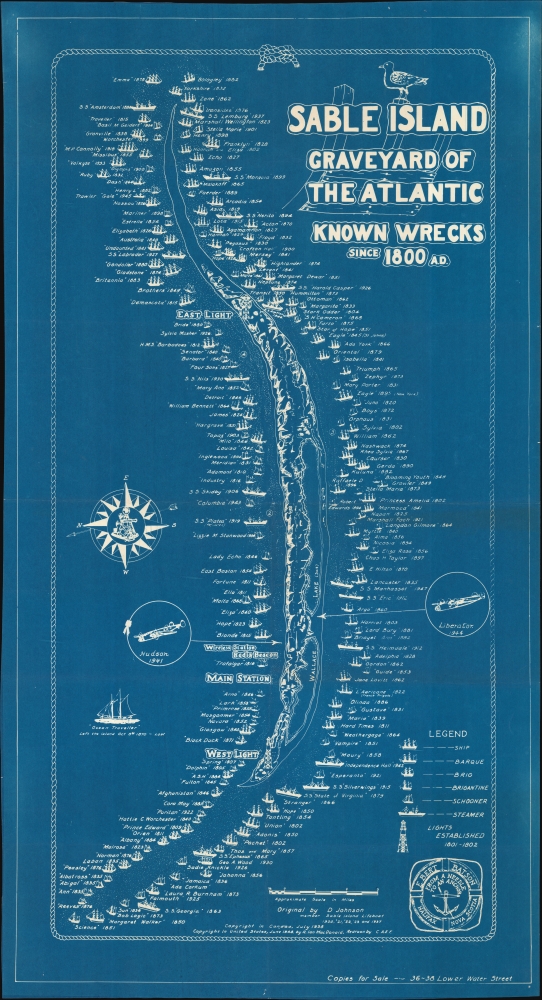
Sable Island Graveyard of the Atlantic Known Wrecks since 1800 A.D.
1948 (dated) 37 x 20 in (93.98 x 50.8 cm) 1 : 54000
1948 (dated) 37 x 20 in (93.98 x 50.8 cm) 1 : 54000
Description
A striking 1948 cyanotype pictorial map of Sable Island, Nova Scotia, drawn by Donald S. Johnson. It highlights the very large number of shipwrecks that occurred around the island in the 19th and early 20th century, especially before the installation of lighthouses.
A Closer Look
The map is oriented to the east, thus depicting the island in a tall profile. Around the island are illustrations of ships and the dates of their wrecks, beginning in 1800 and ending with the S.S. Manhasset, a former World War II cargo ship sunk in 1947. Aside from ships, two airplanes that wrecked during World War II (1939 - 1945) are also noted. A radio beacon, two lighthouses, and several other unlabeled structures are illustrated. The 'Main Station' indicated here has often been the only permanently inhabited building on the island, operated by meteorologists and staff from Parks Canada, though private individuals have also occasionally lived on the island (one naturalist who has lived on the island for the past 40 years was the subject of a recent documentary film).Who Put an Island There?
Sable Island is a distant outpost of Nova Scotia, administratively part of the municipality of Halifax, from which it sits some 190 miles to the east. A 12 square mile crescent-shaped island in the middle of the ocean, often shrouded in fog and surrounded by powerful currents, Sable Island is inconveniently situated near major shipping routes, seemingly almost designed to ensnare passing ships. Although the present map lists shipwrecks from 1800, when the quantity of ships passing through the Atlantic was much greater than in previous centuries, wrecks were recorded as early as 1583. In 1873, the West and East Light lighthouses were constructed, significantly, though not entirely reducing wrecks.Cyanotype: Why so Blue?
Cyanotype is a photo-reprographic technique developed in 1842 by the British astronomer John Herschel (1792 - 1871). Sometimes called a 'sunprint', the technique employs a solution of ferric ammonium citrate and potassium ferricyanide, which, painted on white paper or cloth, reacts when exposed to sunlight to dye the object a brilliant blue. Areas blocked from ultraviolet exposure remain undyed and white. Herschel developed the technique to reproduce his astronomical notes, but others quickly realized that any object capable of blocking light could be used to create a cyanotype image quickly and easily. By the late 19th century, the process became popular with designers, militaries, architects, and engineers, who used the cheap and effective technique to quickly and exactly reproduce images in the field. Cyanotyping is limited in that only a single copy can be made at one time, so it was only practical for short-term field work. It is also of note that cyanotypes remain highly reactive to light and, over time, fade or degrade, making them extremely ephemeral. The process fell out of fashion in most places by the 1920s but remains in use in some parts of the world, such as India and Nepal, to this day.Publication History and Census
This pictorial map was originally drawn by Donald S. Johnson in 1938, but the reference to a 1948 copyright in the United States indicates that this example was printed later. The logo at bottom-right of E. Bert Batson, a Halifax-based seller of a wide variety of goods for mariners, suggests where the map was sold. The 1938 original is only noted among the holdings of the University of Southern Maine and Library and Archives Canada, while this 1948 reprint is held by the University of Florida, the Library of Congress, Dalhousie University, the Memorial University of Newfoundland, the University of Toronto, and the University of British Columbia.Cartographer
Donald Stewart Johnson (fl. c. 1938 - 1948) was the Superintendent of Sable Island from 1939 -1948, except for a period during the Second World War when he helped to set up the Royal Canadian Navy's Fleet Air Arm. His father had been captain of a ship that brought supplies to the island, allowing him to become acquainted with it from a young age. After briefly attending university and working for the Humane Establishment on Sable Island, Johnson joined the Royal Canadian Mounted Police as a constable. Before returning to Sable Island as its superintendent, he worked several jobs with the Mounties and on ships in the Atlantic while also developing his artistic skills as an illustrator. Johnson was known as the 'Atlantic Cowboy' as he often rode horses to get around on Sable Island (the island is famous for a distinctive breed of horse, whose origin is unknown but most likely were resettled after being seized from Acadians during their expulsion by the British during the French and Indian War). More by this mapmaker...
Condition
Very good.
References
OCLC 5568667, 855419142, 1084819647, 977207908.