This item has been sold, but you can get on the Waitlist to be notified if another example becomes available.
1977 de Muns World Map of the Pilgrimage to Santiago de Compostela
SaintIagoMundo-muns-1977$325.00


Title
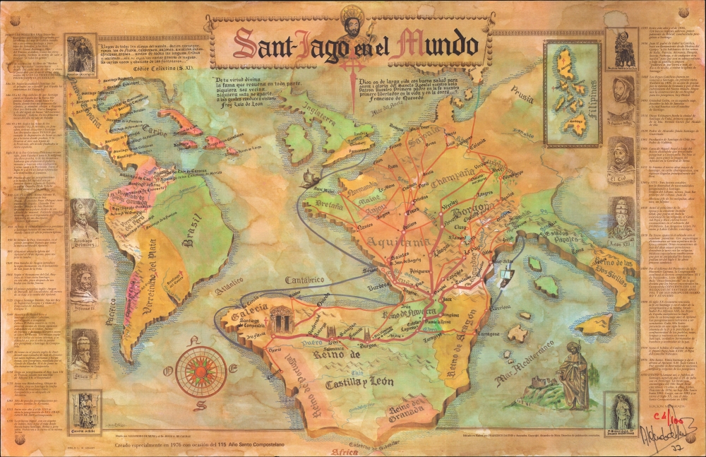
Sant-Iago en el Mundo.
1977 (dated) 23.5 x 36.25 in (59.69 x 92.075 cm)
1977 (dated) 23.5 x 36.25 in (59.69 x 92.075 cm)
Description
A rare 1977 thematic map illustrating the global impact of the Pilgrimage to Santiago de Compostela. The map was issued by Alejandro de Muns Trillo for the 1976 Jacobean Holy Year. It was issued in a limited edition of 100 examples. The present example is (we think) 94 / 100 and signed by de Muns.
A Closer Look
The map covers Latin America, Spain and Portugal, France, and Italy. The Iberian Peninsula, particularly Galicia, is proportionally exaggerated to focus on Compostela. The major pilgrimage routes to Compostela are highlighted in red, with significant stops noted. The most important artery, the Via Lactea (Milky Way), running from the Pyrenees via Logrono, Burgos, and León, stands out. Although no pilgrimage routes connect Compostela to the Americas, numerous sanctuaries of Saint James the Elder dot Latin America extending from Patagonia to California and New Mexico. An inset in the upper right shows how Santiago's influence has spread to the Philippines, where five sanctuaries are noted. In the right and left margins, there is a history of Santiago, including his hagiography, from year 1 to 1976 CE. The map is printed to look antique, with faux-water stains and browned paper.The Pilgrimage of Santiago de Compostela
The pilgrimage route to Santiago de Compostela, also known as the Chemin St. Jacques in French and the Way of Saint James in English, is a late medieval pilgrimage route running from various points around Europe to the cathedral of Santiago de Compostela, believed to be the resting place of the relics of St. James the Elder, the first martyred apostle. It is considered one of the three great Catholic pilgrimages, following Jerusalem and Rome. Like these other pilgrimage destinations, Compostela, located in the northwesternmost part of Spain, lay far from Europe's most populous Christian lands, and the route to get there was both long and arduous. Pilgrims typically traveled by foot, wearing distinctive garb to mark themselves: cape, wide-brimmed hat, and scallop shell. They relied heavily on the charity of strangers as well as refuges established by the church to assist them. The route to Compostela reached its height in the 15th century when Ottoman conquests closed the Holy Land to most Europeans. Over the subsequent centuries, the Compostela pilgrimage waxed and waned in popularity as the constant inter-European wars opened and closed borders. Although largely forgotten in the early 20th century, the routes to Compostela are again crowded with pilgrims and form, in aggregate, Europe's most popular long-distance trek.Publication History and Census
This map was drawn by Alejandro de Muns Trillo and Jesus A. de Caldas in 1976 and published in 1977 for the 115th holy year of Santiago de Compostela. It is a limited edition of just 100 examples, all numbered and signed by Muns. We see no other examples in private or institutional collections. Nor have we been able to trace either Muns or Caldas. Although there is a prominent Madrid lawyer named Muns Trillo and a prominent doctor named Jesus A. de Caldas, we have been unable to connect them to any cartographic efforts. Muns Trillo did, however, issue another stylistically similar map, also in 1976, depicting the United States, entitled The Spanish Heritage and Contribution to the American Independence 1512-1823.Condition
Very good. Printed to look old by publisher.