1923 O'Shaughnessy Street Map of San Francisco, California
SanFrancisco-oshaughnessy-1923$450.00

Title
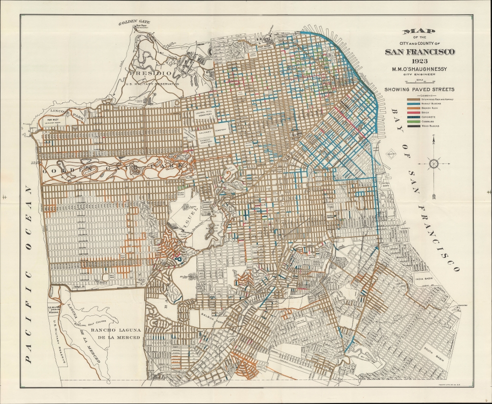
Map of the City and County of San Francisco.
1923 (dated) 25.75 x 33.75 in (65.405 x 85.725 cm) 1 : 19200
1923 (dated) 25.75 x 33.75 in (65.405 x 85.725 cm) 1 : 19200
Description
An example of M. M. O'Shaugnessy's 1923 urban planning map of San Francisco. It highlights the various types and quality of road surfaces throughout the city, while also demonstrating the uncertain future of certain neighborhoods in the quickly growing city.
This map is notable for its inclusion and exclusion of elements of the city landscape that were later modified. For example, the exact future extent of the Marina was unclear at this time, which is why urban development cuts off abruptly just past Lewis St., a short-lived designation in the years when the neighborhood was built on the former site of the 1915 Panama-Pacific International Exhibition. Ultimately, urban development ended at Marina Boulevarda, and north of the boulevard became a small park (effectively an extension of the Presidio), a harbor with docks for yacht clubs, and a small airfield that was later converted into the Marina Green.
Elsewhere, Mission Rock off the city's eastern coast was a grain terminal originally built in the 1870s; over time, additional landfill connected it to the mainland, becoming part of the neighborhood today known as Mission Bay (where here streets are ghosted in). At bottom-center, much of the street grid is speculative though not ghosted; in fact, the area around the reservoir and Lick Old Ladies Home would become part of McLaren Park, not fully planned until 1926. Conversely, the scale of Balboa Park as seen here was later curtailed; a jail on the west side of the Southern Pacific Line (now the route of Interstate 280) presented urban planners with a problem, until it was closed and this portion of land was dedicated to the City College of San Francisco. Around the time of this map's publication, with the increasing use of automobiles, serious consideration began for what would become the Bay Bridge and Golden Gate Bridge, opened the following decade.
A Closer Look
The city and county of San Francisco is presented, with most roads color-shaded to indicate their type of surface, ranging from wood to asphalt, with much of the city retaining various types of brick or cobblestone. Railway lines belonging to the Southern Pacific, the Twin Peaks Tunnel, military and government land, cemeteries, parks, remnants of the Spanish and Mexican era ranchos, golf courses, and other features are labeled throughout.This map is notable for its inclusion and exclusion of elements of the city landscape that were later modified. For example, the exact future extent of the Marina was unclear at this time, which is why urban development cuts off abruptly just past Lewis St., a short-lived designation in the years when the neighborhood was built on the former site of the 1915 Panama-Pacific International Exhibition. Ultimately, urban development ended at Marina Boulevarda, and north of the boulevard became a small park (effectively an extension of the Presidio), a harbor with docks for yacht clubs, and a small airfield that was later converted into the Marina Green.
Elsewhere, Mission Rock off the city's eastern coast was a grain terminal originally built in the 1870s; over time, additional landfill connected it to the mainland, becoming part of the neighborhood today known as Mission Bay (where here streets are ghosted in). At bottom-center, much of the street grid is speculative though not ghosted; in fact, the area around the reservoir and Lick Old Ladies Home would become part of McLaren Park, not fully planned until 1926. Conversely, the scale of Balboa Park as seen here was later curtailed; a jail on the west side of the Southern Pacific Line (now the route of Interstate 280) presented urban planners with a problem, until it was closed and this portion of land was dedicated to the City College of San Francisco. Around the time of this map's publication, with the increasing use of automobiles, serious consideration began for what would become the Bay Bridge and Golden Gate Bridge, opened the following decade.
Publication History and Census
This map was prepared in 1923 by Michael Maurice O'Shaughnessy, San Francisco's city engineer, who more than anyone else helped to shape the city in the aftermath of the 1906 earthquake and fire. It was printed by the Halpin Lithograph Co. in San Francisco. The map most likely appeared in the 1922-1923 Report of the Bureau of Engineering of the Department of Public Works, City and County of San Francisco, though existing digitized examples do not confirm this. Maps with this title or very similar titles were published in preceding and subsequent years, both folded as with the present map and, in some cases, as wall maps. However, there are no examples of this edition of the map in the OCLC, and we are unaware of any on the private market.CartographerS
Michael Maurice O'Shaughnessy (May 28, 1864 - October 12, 1934) was an Irish-born civil engineer who played an important role in the urban planning and infrastructure of San Francisco in the early 20th century, including in the reconstruction from the 1906 earthquake and fire. Bor in County Limerick, O'Shaughnessy studied civil engineering at several institutions, ultimately graduating from the Royal University of Dublin. While looking for a job in London, he was encouraged to try moving to California instead, which he did, arriving in San Francisco in March 1885. Unable to find work in San Francisco, he instead found employment planning cities and towns further in the interior of northern and central California, experience that would late prove helpful in determining a reliable water supply for San Francisco. By 1891, O'Shaughnessy had begun engineering projects in San Francisco itself, but still also worked elsewhere, including a stint in Hawaii, where he designed irrigation systems for sugar plantations. In 1912, O'Shaughnessy became city engineer for San Franciso, accepting a significant pay cut for the opportunity to shape several projects, including securing drinking water for the city (working with the private Spring Valley Water Co. and the Hetch Hetchy Project, building a dam and reservoir near Yosemite and channeling the resulting water to the city), the Geary Street Railway (an early component in the city's electric streetcar network), multiple tunnels through San Francisco's hills for streetcars, and various infrastructure and reconstruction projects related to roads, sewers, electricity, gas lines, and so on. O'Shaughnessy served as city engineer until 1932, when he took on an advisory role until his death two years later. He left a deep imprint on the city's layout and infrastructure. Multiple sites, including the dam at Hetch Hetchy, are named in his honor. More by this mapmaker...
Halpin Lithograph Co. (c. 1914 - 1920) was a short-lived lithographic printer in San Francisco that specialized in maps and publications for the city government and associated bodies (such as chambers of commerce). Learn More...
Condition
Very good. Light wear along original folds.