
This item below is out of stock, but another example (left) is available. To view the available item, click "Details."
Details
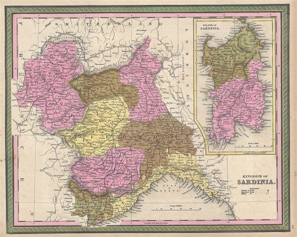
1849 Mitchell Map of the Kingdom of Sardinia and Peidmont, Italy
1849 (undated) $150.00
1849 Mitchell Map of Italy: Kingdom of Sardinia and Piedmont
Sardinia-mitchell-1849$75.00

Title
Kingdom of Sardinia.
1849 (undated) 13 x 16 in (33.02 x 40.64 cm) 1 : 1200000
1849 (undated) 13 x 16 in (33.02 x 40.64 cm) 1 : 1200000
Description
This is a fine example of Thomas Cowperthwait and S. A. Mitchell's 1849 map of Kingdom of Sardinia. Centered in Piedmont, this map covers the Kingdom of Sardinia's claims both on the Island of Sardinia and the mainland provinces of Piedmont, Savoy, Aosta, Coni, Nice, and Genoa. The whole is engraved in Mitchell's distinctive style with green border work and vivid pastels. Political and topographical features are noted and color coded with elevation rendered by hachure.
The Kingdom of Sardinia or Piedmont-Sardinia was ruled by the House of Savoy since 1720, barring a short period when the mainland domains were annexed by Napoleonic France. The Congress of Vienna however returned these territories to the House of Savoy in 1814 with the inclusion of Genoa. In 1848, just a year before this map was made, King Charles Albert proposed a new constitution, which would eventually become the constitution of the unified Kingdom of Italy in 1861. The region would also be on the brink of the Crimean War (1853 – 1856), a conflict between the Kingdom of Sardinia along with the allied forces of the British, French and Ottoman Empires against the Russian Empire.
This map was prepared by S. A. Mitchell for publication by the Philadelphia firm of Thomas Cowperthwait & Co. as plate no. 55 in the 1849 edition of Mitchell's New General Atlas.
Cartographer
Samuel Augustus Mitchell (March 20, 1792 - December 20, 1868) began his map publishing career in the early 1830s. Mitchell was born in Bristol, Connecticut. He relocated to Philadelphia in 1821. Having worked as a school teacher and a geographical writer, Mitchell was frustrated with the low quality and inaccuracy of school texts of the period. His first maps were an attempt to rectify this problem. In the next 20 years Mitchell would become the most prominent American map publisher of the mid-19th century. Mitchell worked with prominent engravers J. H. Young, H. S. Tanner, and H. N. Burroughs before attaining the full copyright on his maps in 1847. In 1849 Mitchell either partnered with or sold his plates to Thomas, Cowperthwait and Company who continued to publish the Mitchell's Universal Atlas. By about 1856 most of the Mitchell plates and copyrights were acquired by Charles Desilver who continued to publish the maps, many with modified borders and color schemes, until Mitchell's son, Samuel Augustus Mitchell Junior, entered the picture. In 1859, S.A. Mitchell Jr. purchased most of the plates back from Desilver and introduced his own floral motif border. From 1860 on, he published his own editions of the New General Atlas. The younger Mitchell became as prominent as his father, publishing maps and atlases until 1887, when most of the copyrights were again sold and the Mitchell firm closed its doors for the final time. More by this mapmaker...
Source
Mitchell Jr., S. A., Mitchell's New General Atlas, Containing Maps Of The Various Countries Of The World, Plans Of Cities, Etc. Embraced In Forty-Seven Quarto Maps, Forming A Series Of Seventy-Six Maps And Plans, Together With Valuable Statistical Tables, 1849 edition.
Condition
Very good. Some foxing at places.
References
Rumsey 0545.059. Phillips (Atlases) 797.