1760 Seutter / Lotter Map of Saxony, Emphasizing Silver Mines
SaxonySilverMines-seutter-1760$2,200.00


Title
Mappa Geographica Circuli Metalliferi Electoratus Saxoniae cum omnibus quae in eo comprehenduntur Praefecturis...
1760 (undated) 23.25 x 38.75 in (59.055 x 98.425 cm) 1 : 170000
1760 (undated) 23.25 x 38.75 in (59.055 x 98.425 cm) 1 : 170000
Description
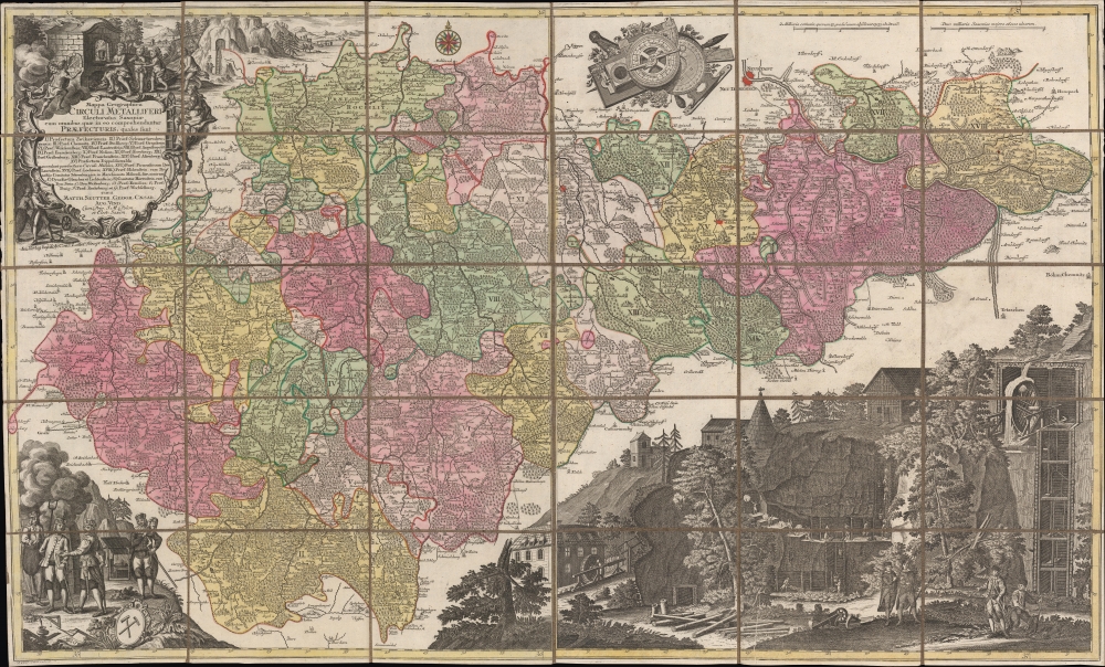
A spectacular c. 1760 map of Saxony by Matthäus Seutter, engraved by Tobias Conrad Lotter. Brightly colored and richly illustrated, it focuses on the region's important silver mining operations, which were a major source of silver throughout Europe dating back to the Middle Ages.
Lively illustrations depicting the silver mines surround the map. Around the title cartouche are earthly miners delivering silver ore below and mythological figures smelting silver above. In the background is a mine and several nearby towns. At bottom-left, mine supervisors (duix) present their product to a wealthy figure, likely a merchant or nobleman. At bottom-right is a magnificently detailed drawing of the various parts of a mine operation, both above and below the surface, highlighting the importance of waterpower to mining in the era before steam power.
A seemingly minor but important detail is the crossed swords southeast of Dresden, near Pirna. These mark the site of the Battle of Maxen, on November 20, 1759, part of the Third Silesian War, which itself was tied to the global Seven Years' War. The battle was a resounding success for the Austrians against the Prussians, but the entire conflict resulted in a Prussian victory, confirming its control of Silesia. More directly for our purposes, this symbol and date help to distinguish this state of the map from others.
A Closer Look
Saxony is displayed as divided into 25 'prefectures' and other administrative divisions, giving some hint of the complexity of authority in the region, as with most parts of the Holy Roman Empire. Cities, towns, villages, waterways, roads, forests, mountains, fortresses, and other features are indicated throughout. Dresden appears at top towards right (subdivided at the Elbe River into Neu Dresden and Neustadt). Other cities are similarly colored red and presented with fortifications, as with the great university town of Freiburg (Freyburg). Dresden, Freiburg, and other cities in the region were in large part sustained and developed due to the silver mines which are the map's thematic inspiration.Lively illustrations depicting the silver mines surround the map. Around the title cartouche are earthly miners delivering silver ore below and mythological figures smelting silver above. In the background is a mine and several nearby towns. At bottom-left, mine supervisors (duix) present their product to a wealthy figure, likely a merchant or nobleman. At bottom-right is a magnificently detailed drawing of the various parts of a mine operation, both above and below the surface, highlighting the importance of waterpower to mining in the era before steam power.
A seemingly minor but important detail is the crossed swords southeast of Dresden, near Pirna. These mark the site of the Battle of Maxen, on November 20, 1759, part of the Third Silesian War, which itself was tied to the global Seven Years' War. The battle was a resounding success for the Austrians against the Prussians, but the entire conflict resulted in a Prussian victory, confirming its control of Silesia. More directly for our purposes, this symbol and date help to distinguish this state of the map from others.
The Silver Mines of Saxony
The Ore Mountains, or Erzgebirge / Krušnohoří, spanning Saxony and the northwestern part of Bohemia are particularly blessed with silver, and for centuries served as one of the main sources of the metal in Europe. Beginning in the 12th century in a forest just outside of Freiburg, silver mines operated throughout this region well into the 20th century. The industry saw its ups and downs, including what may have been the first speculative financial bubble in history in the late 15th century. Eventually, silver from the New World overtook Saxony. The Thirty Years' War (1618 - 1648) was also extremely destructive for the mining industry. Still, the mines recovered their previous status somewhat in the late 17th and 18th centuries and helped to develop metallurgy as a science through the Bergakademie Freiberg (Freiberg Mining Academy). Silver mining continued into the 20th century and has been partially revived in recent years. It remains an important part of the region's identity, as with the Mining Town Festival (Bergstadtfest) held every June in Freiburg. The Erzgebirge / Krušnohoří Mining Region was declared a World Heritage Site in 2019.Publication History and Census
This map was engraved and published around the year 1760 by Conrad Tobias Lotter, based on an earlier edition engraved by Lotter and ascribed to Matthäus Seutter, who had died by the time of publication. Though undated, the aforementioned reference to the Battle of Maxen means it must date from 1760 or later (the publication note below the title also suggests a date after Seutter's death in 1757). Variations on this map dating back to c. 1735 appear in multiple OCLC listings, though usually with a slightly different title than the present example ('Praefecturis Et Dynastiis' instead of simply 'Praefecturis'). Those with the same title as this map are dated 'nach 1755' or 'nach 1758.' With either date, the map is only noted among the holdings of four institutions: the Staatliche Bibliothek Regensburg, the Universitäts- und Landesbibliothek Sachsen-Anhalt / Zentrale, the Sächsische Landesbibliothek - Staats- und Universitätsbibliothek Dresden, and the Universitätsbibliothek Bern. The full map consists of two sheets, and often only the left-side sheet with the title cartouche appears in institutional collections and on the market. The present example includes both sheets and is especially atypical in that they are dissected and laid on linen for folding, making it a perhaps unique presentation of this rare and elaborate map.CartographerS
Matthäus Seutter (1678 - 1757) was one of the most important and prolific German map publishers of the 18th century. Seutter was born the son of a goldsmith but apprenticed as a brewer. Apparently uninspired by the beer business, Seutter abandoned his apprenticeship and moved to Nuremberg where he apprenticed as an engraver under the tutelage of the prominent J. B. Homann. Sometime in the early 1700s Seutter left Homann to return to Augsburg, where he worked for the prominent art publisher Jeremiad Wolff (1663 - 1724), for whom he engraved maps and other prints. Sometime around 1717 he established his own independent cartographic publishing firm in Augsburg. Though he struggled in the early years of his independence, Seutter's engraving skill and commitment to diversified map production eventually attracted a substantial following. Most of Seutter's maps are heavily based upon, if not copies of, earlier work done by the Homann and De L'Isle firms. Nonetheless, by 1731/32 Seutter was one of the most prolific publishers of his time and was honored by the German Emperor Karl VI who gave him the title of Imperial Geographer, after which most subsequent maps included the Avec Privilege designation. Seutter continued to publish until his death, at the height of his career, in 1757. Seutter had two engraver sons, Georg Matthäus Seutter (1710 - 173?) and Albrecht Carl Seutter (1722 - 1762). Georg Matthäus quit the business and relocated to Woehrdt in 1729 (and probably died shortly thereafter), leaving the family inheritance to his wastrel brother Albrecht Carl Seutter, who did little to advance the firm until in own death in 1762. Following Albrecht's death, the firm was divided between the established Johann Michael Probst (1727 - 1776) firm and the emerging firm of Tobias Conrad Lotter. Lotter, Matthäus Seutter's son-in-law, was a master engraver and worked tirelessly on behalf of the Suetter firm. It is Lotter, who would eventually become one of the most prominent cartographers of his day, and his descendants, who are generally regarded as the true successors to Matthäus Seutter. (Ritter, M. Seutter, Probst and Lotter: An Eighteenth-Century Map Publishing House in Germany., "Imago Mundi", Vol. 53, (2001), pp. 130-135.) More by this mapmaker...
Tobias Conrad Lotter (1717 - 1777) was a German engraver and map publisher. Lotter was the son of a baker and city guardsman, but married Euphrosina (1709 - 1784) Seutter, elder daughter of the prominent map publisher Matthäus Seutter. He began working at his is father-in-law's map business about 1740. Between 1740 and 1744 he produced, under Seutter's imprint, the Atlas minor, Praecipua orbis terrarum imperia, regna et provincias, Germania potissimum tabelli. Upon Seutter's death, in 1757, the firm's stock was taken over by his son, Albrecht Karl Seutter (1722 - 1762), who himself died in 1762, just a few years later. The remaining Seutter map plates were subsequently divided between Lotter and the publisher Johan Mitchell Probst (1727 - 1776). With the support of his sons, Matthäus Albrecht (1741 - 1810), Georg Friedrich (1744 - 1801) and Gustav Conrad (1746-1776), Tobias Conrad Lotter succeeded in building on the economic success and professional reputation of his father-in-law. In time, Lotter became one of the most prominent mid-18th century map publishers working in the German school. After Lotter's death in 1777, the business was taken over by his two eldest sons, who, lacking their father's business acumen, presided over the firm's slow decline. It was nonetheless passed on to a subsequent generation of Lotters, Matthäus Albrecht Lotter's sons, Gabriel (1776 - 1857) and Georg Friedrich (1787 - 1864), who pushed it into further decline until it faded out in the early-19th century. Learn More...
Condition
Very good. Some wear and loss along edge. Creasing in margins, occasionally intruding into image. Dissected and laid on linen.