This item has been sold, but you can get on the Waitlist to be notified if another example becomes available, or purchase a digital scan.
1860 Tallis Map of Sebastopol, Balaklava & the Crimean Peninsula, Russia
Sebastopol-tallis-1860$85.00

Title
Siege of Sebastopol
1860 10.5 x 13.5 in (26.67 x 34.29 cm)
1860 10.5 x 13.5 in (26.67 x 34.29 cm)
Description
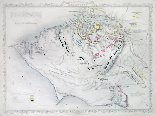
This hand colored map is a copper plate engraving of the city of Sebastopol, Russia. It depicts the city and areas surrounding Sebastopol & Balaklava (western Crimean Peninsula) in incredible detail. Sebastopol's place in history was cemented during the Crimean War. Seeking to punish Russia for its imperialistic designs on the Balkans Napoleon III and his allies, the English & Turks, invaded the peninsula, quickly taking Balaklava. The high point of the war was the legendary and disastrous 'Charge of the Light Brigade' wherein an entire British Calvary unit charged to its death against a fortified Russian position. This map was made by Tallis, a well known English cartographer known for his attention to detail and elaborate decorative borders.
Cartographer
John Tallis and Company (1838 - 1851) published views, maps, and atlases in London from roughly 1838 to 1851. Their principal works, expanding upon the earlier maps of John Cary and Aaron Arrowsmith, include an 1838 collection of London Street Views and the 1849 Illustrated Atlas of the World. The firm’s primary engraver was John Rapkin, whose name and decorative vignettes appear on most Tallis maps. Due to the embellishments typical of Rapkin's work, many regard Tallis maps as the last bastion of English decorative cartography in the 19th century. Although most Tallis maps were originally issued uncolored, it was not uncommon for 19th century libraries to commission colorists to "complete" the atlas. The London Printing and Publishing Company of London and New York bought the rights for many Tallis maps in 1850 and continued issuing his Illustrated Atlas of the World until the mid-1850s. Specific Tallis maps later appeared in innumerable mid to late-19th century publications as illustrations and appendices. More by this mapmaker...
Condition
Very good condition. Original centerfold.