This item has been sold, but you can get on the Waitlist to be notified if another example becomes available, or purchase a digital scan.
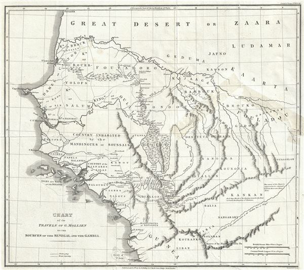
1820 Phillips Map of Senegal and Gambia, Western Africa (Travels of G. Molliens)
SenegalGambia-phillips-1820$75.00

Title
Chart of the Travels of G. Mollien to the Sources of the Senegal and the Gambia.
1820 (dated) 15 x 16 in (38.1 x 40.64 cm) 1 : 3650000
1820 (dated) 15 x 16 in (38.1 x 40.64 cm) 1 : 3650000
Description
This is a fascinating 1820 map of western Africa by Richard Phillips illustrating the travels of Gaspard Theodore Mollien to the sources of the Senegal and Gambia Rivers. It covers modern day Senegal and Gambia along with neighboring Mauritania, Guinea, Guinea-Bissau and Mali. The map names numerous African tribes and nations throughout, and offers other interesting cartographic annotations. Rivers, lakes, mountains and other topography is also noted, with relief shown by hachure. Mollien's routes while going and returning are identified.
A French diplomat and explorer, Mollien was one of the earliest explorers of the interiors of western Africa. He bagan his journey in 1817 from Saint-Louis in Senegal (route shown on map) and traveled until 1919, exploring Senegal, Guinea and Portuguese Guinea, in an attempt to discover the sources of the Senegal, Gambia and Niger rivers. Although his attempt to discover the source of the Niger failed, he was one of the first Europeans to be in contact with the tribes of this region. The map notes 'the direction of the supposed source of the Niger' and 'the source of the Niger is supposed to be situated between these two meridians.'
This region was particularly important in the early 19th century as the source of most African slaves imported to the New World. Even so, at the time this map was made, the slave trade, thriving since the 5th century was rapidly diminishing due to decreased demand for slaves in the New World, the British outlawing of slavery in 1808, and subsequent diplomatic efforts including treaties with over 50 African rulers outlawing the practice. Many African economies adapted by shifting to the export of mineral and agricultural resources, which led to the European scramble for territory, occupying most of the continent by the end of the 19th century. Europe's colonial interests in Africa haphazardly carved up the continent into unnatural territories, often forcing historic enemies into close proximity and leading to social problems that remain to this day.
This map was published by Sir Richard Phillips in his Journal of Voyages.
Condition
Good. Minor wear along original fold lines. A couple of large tear near lower left quadrant and top right quadrant, both repaired. The top right tear was previously repaired with tape on recto. The tape has been removed and area cleaned, but some glue residue still remains. Professionally flattened and backed with archival tissue for stability. Damaged, but very rare map.