This item has been sold, but you can get on the Waitlist to be notified if another example becomes available, or purchase a digital scan.
1880 Pair of Serio-Comic Maps in Persian (Rose and Kordig)
SerioComicMapPersian-kordigrose-1880$7,000.00

Title
Serio-Comic Map of Europe. / Russian map of Europe.
1880 (undated) 15.5 x 21 in (39.37 x 53.34 cm) 1 : 9000000
1880 (undated) 15.5 x 21 in (39.37 x 53.34 cm) 1 : 9000000
Description
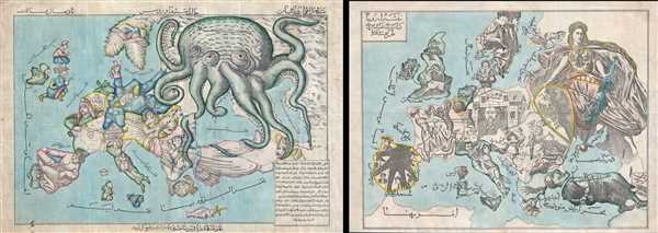
An extraordinary discovery, this is a here-to-fore unknown set of Persian Serio-Comic maps issued around 1880 in Iran. These Serio-Comic maps presuppose that the reader will recognize the familiar shape of Europe and its constituent nations, which have here been replaced by caricatures, each of which tell their own political story. Both Persian Serio-Comic maps offered here are derived from European proto-types and but are far from mere slavish copies translated into Farsi /Persian. Instead, they are unique productions with certain revisions and updates to make the maps more interesting to an Iranian audience.
The left hand map is an interpretation of Englishman Fred Rose's iconic 1877 Serio Comic War Map, in which expansionist Imperial Russia is analogized as a menacing grasping octopus. The right hand map is derived from an obscure and nearly unknown Russian Serio Comic map drawn in response to Rose by K. I. Kordig. Kordig analogizes Russia as a heroic, nearly angelic defender shielding the people of Russia from the feuding, base, chaotic, and morally corrupt nations of Western Europe.
Iranians at this time were beset by incursions from both Western Europe, in terms of increased English activity in southwestern Iran, and Russian political penetration in the from strong inter-dependent alliances with the Qajar elite. The Qajar also borrowed substantially from both England and Russia, creating a deep network of financial ties. This pair of maps, clearly issued in concert, was no doubt intended to illustrate and satirize conflicting perspectives for the educated Iranian public.
The left map, a variant of the famous 'Octopus Map,' illustrates Rose's responding to the Balkan Crises of 1877, wherein British interests were perceived to be under threat from the expansionistic zeal of the Russian Tsar.
In Rose's own words:
Fortunately there is textual description in Farsi to make all clear:
To be fair, although Rose popularized the convention of representing the Russia as a menacing octopus, it was in fact the Dutchman J. J. Van Brederode in 1870, who produced the first version of this map, the Humoristische-oorlogskaart. The convention of representing Russia as an octopus afterwards became extremely popular and was adopted by other caricaturists in Japan, Iran (as here), and elsewhere.
The right hand map is exceptionally enigmatic. It is based upon a Russian response to the Fredric Rose drawn by K. I. Kordig. We have identified no surviving examples of the Russian map with the exception of a c. 1883 reprint, issued on a handkerchief, which was sold at Dreweatts in 2014. Unfortunately this leaves us to our own imagination and scholarship to interpret the map. Fortunately, the message is clear: Russia is an angelic figure ready with shield and sword to defend her people and culture. The west of Europe is in chaos. Germany is represented by Otto von Bismark, who holds up a rickety house. England is a vicious dog, aggressively keeping its neighbors, Scotland (quivering peasant) and Ireland (scared cat), in line. Belgium and Holland are fat and bloated with their own wealth and self-importance. Denmark is a greedy opportunist. France attempts to pull apart the already shaky Germany while ignoring the polycephalous serpent in its own backyard. Spain is beset by La Mano Negra or 'Black Hand,' an alleged secret and violent anarchist organization founded in Andalucía. (Even today it is not clear if La Mano Negra actually existed, or if it was an invention of the government of Praxedes Mateo Sagasta to combat the revolts of the countryside in the south of Spain, as Vicente Blasco Ibanez claimed in his novel La Bodega.) Italy is represented by nationalists and the Papacy fighting over Rome while Sicily rests and spits. Hungary turns its attention toward the Balkans while Austria digs its own grave. The Ottoman Empire is an aggressive cannibal attempting to gobble up Bulgaria while tiny but bold Greece seems ready to attack from behind. Iran, in the lower right, tugs on Turkey's pant leg trying in vain to keep it out of European conflicts. In the upper left the title in Farsi translates as Replica of the Russian map of Europe.
Both maps are laid down on linen with a manuscript annotation on the verso. One reads:
The Russian map also bears an inscription on the verso that reads, roughly,
The left hand map is an interpretation of Englishman Fred Rose's iconic 1877 Serio Comic War Map, in which expansionist Imperial Russia is analogized as a menacing grasping octopus. The right hand map is derived from an obscure and nearly unknown Russian Serio Comic map drawn in response to Rose by K. I. Kordig. Kordig analogizes Russia as a heroic, nearly angelic defender shielding the people of Russia from the feuding, base, chaotic, and morally corrupt nations of Western Europe.
Iranians at this time were beset by incursions from both Western Europe, in terms of increased English activity in southwestern Iran, and Russian political penetration in the from strong inter-dependent alliances with the Qajar elite. The Qajar also borrowed substantially from both England and Russia, creating a deep network of financial ties. This pair of maps, clearly issued in concert, was no doubt intended to illustrate and satirize conflicting perspectives for the educated Iranian public.
The left map, a variant of the famous 'Octopus Map,' illustrates Rose's responding to the Balkan Crises of 1877, wherein British interests were perceived to be under threat from the expansionistic zeal of the Russian Tsar.
In Rose's own words:
The Octopus (Russia, the great glutton) no longer thinks about the wounds received during the Crimean War, and advances its armies in all directions. After having stemmed the Turk’s advance, the Russian marches forward, hoping to crush Turkey like he did with Poland. It seems Greece is also desirous to occupy and exhaust Turkey from another direction. Hungary is restrained only by its sister Austria from attacking Russia. France, still smarting from its recent defeat, is studiously inspecting its arsenal. Germany is observing France’s movements, and is prepared for all eventualities. Great Britain and Ireland are carefully monitoring the situation, and are prepared to prevent Russia from imposing itself on Turkey, or interfering in the Suez. Spain is taking a much-needed nap. Italy is toying with the Pope, while the rich King of the Belgians is securing his treasure. Denmark may have a small flag, but it has reasons to be proud.After reading Rose's description above, as printed on the first 1877 version of the map, published by Bacon, the careful observe will note several difference in this, our Persian variant. France, which in Rose's version, is Marshal MacMahon pointing a mitrailleuse towards Germany, is here a monk holding a scroll on which is a heart and text, which reads, in roughly translation from Farsi, 'Paris is the heart of the world and everyone wishes to be there' - suggestive of a strong Iranian affinity towards France. This somewhat undermines' Germany's position, which in the Rose map has its attention on France, but here, looks eastward towards Russia. Norway in Sweden, which Rose largely ignores, are here represented as happy sleeping babes. Sicily, which Rose drew as three wine barrels, here takes on a form that is rather hard to identify.
Fortunately there is textual description in Farsi to make all clear:
- England: is in hurry to not be left out.
- Spain: on account of keeping its power does not change anything and does nothing.
- Portugal: Always keeps up his appearances.
- France: all worlds wishes.
- Switzerland: An old wooden home who the wolves respect.
- Italy: Slipping everywhere.
- Sweden and Norway: they are as deeply asleep as they are not ready to do anything.
- Denmark: Keeps the flag of the seas.
- Finland: Seems like an old and broken mill.
- Belgium: The god of gold, silver, wealth and parties.
- Germany: Just watching his neighbor but doesn’t know what to do.
- Austria: Is busy with keeping Hungary back, but Hungary wants to fight.
- Greece: Is a marine animal that wants to come to land.
- Ottoman Empire: Is cut in two parts in the claws of an old animal (Russia).
- Russia: Is stretching his tentacles everywhere despite that some could cut them off, like Crimea and Japan.
- Iran : Is merely looking at the world with no benefit to is watching, (we) hope to wake up and act.
To be fair, although Rose popularized the convention of representing the Russia as a menacing octopus, it was in fact the Dutchman J. J. Van Brederode in 1870, who produced the first version of this map, the Humoristische-oorlogskaart. The convention of representing Russia as an octopus afterwards became extremely popular and was adopted by other caricaturists in Japan, Iran (as here), and elsewhere.
The right hand map is exceptionally enigmatic. It is based upon a Russian response to the Fredric Rose drawn by K. I. Kordig. We have identified no surviving examples of the Russian map with the exception of a c. 1883 reprint, issued on a handkerchief, which was sold at Dreweatts in 2014. Unfortunately this leaves us to our own imagination and scholarship to interpret the map. Fortunately, the message is clear: Russia is an angelic figure ready with shield and sword to defend her people and culture. The west of Europe is in chaos. Germany is represented by Otto von Bismark, who holds up a rickety house. England is a vicious dog, aggressively keeping its neighbors, Scotland (quivering peasant) and Ireland (scared cat), in line. Belgium and Holland are fat and bloated with their own wealth and self-importance. Denmark is a greedy opportunist. France attempts to pull apart the already shaky Germany while ignoring the polycephalous serpent in its own backyard. Spain is beset by La Mano Negra or 'Black Hand,' an alleged secret and violent anarchist organization founded in Andalucía. (Even today it is not clear if La Mano Negra actually existed, or if it was an invention of the government of Praxedes Mateo Sagasta to combat the revolts of the countryside in the south of Spain, as Vicente Blasco Ibanez claimed in his novel La Bodega.) Italy is represented by nationalists and the Papacy fighting over Rome while Sicily rests and spits. Hungary turns its attention toward the Balkans while Austria digs its own grave. The Ottoman Empire is an aggressive cannibal attempting to gobble up Bulgaria while tiny but bold Greece seems ready to attack from behind. Iran, in the lower right, tugs on Turkey's pant leg trying in vain to keep it out of European conflicts. In the upper left the title in Farsi translates as Replica of the Russian map of Europe.
Both maps are laid down on linen with a manuscript annotation on the verso. One reads:
From the library of his excellency Adib the head of education [unreadable text] Mirza Ahmad Khan Motazed Dowleh Saba, the tutor of Crown Prince Mozaffar ad-Din. Tabriz, 1210 AH.These are known figures in Iranian History. Mozaffar ad-Din Shah Qajar (1853 - 1907) became the fifth Qajar King of Persia reigning between 1896 and 1907. The tutor is most likely Mirza Ahmad Khan 'Motazed-Dowleh' Vaziri (1869-1924). Mozaffar was a powerful Iranian political figure with a keen interest in education, founding numerous modern schools in the first part of the 20th century.
The Russian map also bears an inscription on the verso that reads, roughly,
This is a remembrance of me to my dear son Mr. Niv. I hope it would be a memento of my love to him and his respectable family. This belonged to my grandfather, the head of education of Tabriz, His Excellency Mirza Ahmad Khan Motazed Dowleh Saba who was the tutor of Mozaffar el Din Shah and it is about 150 years old. I gift it to my son, god willing he does not forget me. - Amir Houshang Mohtasham, 1384 hijri khorshidi.Our research suggests that these are the only known examples of these two maps, with no other examples in evidence in either public or private collections. A once in a lifetime discovery.
CartographerS
Frederic William Rose (November 12, 1849 - January 3, 1915) was a politically conservative British satirist and caricature artist active in the late 19th century. There has been considerable debate regarding Rose's actual identity, due not to any attempt at secrecy, but rather at the commonality of the name. Nonetheless, recently book dealers Laurence Worms and Roderick Barron unearthed a great deal of new information about Rose and, apparently, we can anticipate an upcoming book. According to Worms, Rose was born to a well to do Paddington family of Scottish descent, the son of Major Hugo Monroe St. Vincent Rose of Glastullich and Frances Walrond Roberts. He was appointed as a clerk in the Legacy Duty office at Somerset House - where he was employed, in various positions, for the remainder of his working days. Rose married Catherine Rose Gilchrist and moved to London, where the Rose family lived at 9 Kensington Crescent before, in 1873, relocating to 4 Cromwell Crescent, where they remained. Rose traveled extensively throughout Europe and in 1885 published Notes on a Tour in Spain. In 1891 he divorced his wife on the grounds that she committed adultery - a rather humiliating and uncommon claim at the time. He wrote several other books and subsequently lost two of his sons in World War I. He died in London in 1915. In cartographic circles, Rose is best known for popularizing the caricature map in Europe. His most famous and influential work, while copied from Dutchman J. J. Van Brederode, is the 'Serio-Comic War Map', which represents late 18th century Russia as a grasping Octopus. Nonetheless, he also issued several other maps including another map of Europe entitled 'Angling in Troubled Waters' and variant of the Octopus map entitled 'John Bull and his Friends'. A less well known Rose map focuses on the British Isles and satirizes the 1880 Gladstone Government. More by this mapmaker...
K. I. Kordig (fl. c. 1880) was a Russian illustrator and cartoonist active in the latter part of the 19th century. Kordig is an elusive figure of which little is known. His primary contribution to cartography is a reprisal to Fredric Rose's 1877 Serio-Comic War Map of Europe. Where Rose represents Russia as a grasping and menacing octopus, Kordig, presents Russia as an angelic figure ready to defend its people against the moral bankruptcy and chaos of Western Europe. Learn More...
Condition
Good. Backed on old original linen. Some soiling.