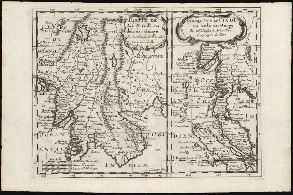
1683 Nicolas Sanson Map of Siam and the Malay Peninsula
Siam-sanson-1683$350.00

Title
Partie de l'Inde au delà du Gange/ Presqu-Isle de L'Inde au delà du Gange.
1683 (undated) 7.25 x 9.75 in (18.415 x 24.765 cm) 1 : 17000000
1683 (undated) 7.25 x 9.75 in (18.415 x 24.765 cm) 1 : 17000000
Description
These, on one sheet, are Nicolas Sanson's 1653 maps of Southeast Asia, here re-engraved for its first Dutch edition of 1683. Coverage includes Siam (Thailand), Vietnam, Cambodia, Laos, Burma, Malaya, and parts of China and Sumatra, a region then generally known as 'India beyond the Ganges.
A Closer Look
The plate contains two maps: the first focuses on the mainland, embracing the watershed of the mythical lake Chiamay, the Kingdom of Siam, and the frontier of Cochinchina and southwestern China and the second depicts the Malay Peninsula, northern Sumatra, and the archipelago containing the Andaman and Nicobar Islands.The Lake of Chiamay
Prominent in this first map is the Lake of Chiamay, the apocryphal source of four important Southeast Asian river systems including the Irrawaddy, the Dharla, the Chao Phraya, and the Brahmaputra. This lake (also called Chiam-may or Chian-may) began to appear in maps as early as the 16th century and persisted well into the mid-18th century. Its origins are unknown but may originate in a lost 16th century geography prepared by the Portuguese scholar Jao de Barros. It was speculated to be the source of five important Southeast Asian River systems and was mentioned in the journals of Sven Hedin. There are even records that the King of Siam led an army to seize of the lake in the 16th century.The Malay Peninsula and Sumatra
The second map, at approximately the same scale, covers the Malay Peninsula, northern Sumatra, and the archipelago containing the Andaman and Nicobar Islands. The Kingdom of Pegu (now Burma) and the northern part of Vietnam (Tunquin) appear, as does part of the Gulf of Tonkin (Golfe de Cochinchine, here.) But north of this, the regions of Timocoues, Gueyes, Ciocangue, and Layes (Laos) appear at the headwaters of the Mekong River. This region was largely ignored by other seventeenth century geographers: Blaeu's maps had covered this region with a cartouche, and Martino Martini's China did not reach so far west. Sanson's source map for Laos and points north is obscure to us.The International Edition
Sanson's small-format atlas, published in four volumes each dedicated to its own continent, had proved popular in Paris. In 1683, an edition collecting all four parts was published by Ribbius in Utrecht. The text was written by historian and exoticist Simon de Vries, and the maps were newly-engraved by Anthonie de Winter. They were faithful and skilled copies of those engraved for Sanson by Peyrounin in Paris.Publication History and Census
This map was initially produced in 1653 for inclusion in Sanson's L'Asie En Plusieurs Cartes Nouvelles Et Exactes; Et En Divers Traittés De Geographie et D'Histoire. It was re-engraved in Utrecht for inclusion in the 1683 Geographische en historische beschryvingh der vier bekende werelds-deelen Europa, Asia, Africa en America, published by Ribbius. The present example corresponds with this first, 1683 state of the map. In 1700, when the maps were republished in Amsterdam by François Halma, the plate was reworked, with more boldly engraved borders. The atlas is well represented in institutional collections. Five examples of the separate map are cataloged in OCLC.CartographerS
Nicolas Sanson (December 20, 1600 - July 7, 1667) and his descendants were the most influential French cartographers of the 17th century and laid the groundwork for the Golden Age of French Cartography. Sanson was born in Picardy, but his family was of Scottish Descent. He studied with the Jesuit Fathers at Amiens. Sanson started his career as a historian where, it is said, he turned to cartography as a way to illustrate his historical studies. In the course of his research some of his fine maps came to the attention of King Louis XIII who, admiring the quality of his work, appointed Sanson Geographe Ordinaire du Roi. Sanson's duties in this coveted position included advising the king on matters of geography and compiling the royal cartographic archive. In 1644, he partnered with Pierre Mariette, an established print dealer and engraver, whose business savvy and ready capital enabled Sanson to publish an enormous quantity of maps. Sanson's corpus of some three hundred maps initiated the golden age of French mapmaking and he is considered the 'Father of French Cartography.' His work is distinguished as being the first of the 'Positivist Cartographers,' a primarily French school of cartography that valued scientific observation over historical cartographic conventions. The practice result of the is less embellishment of geographical imagery, as was common in the Dutch Golden Age maps of the 16th century, in favor of conventionalized cartographic representational modes. Sanson is most admired for his construction of the magnificent atlas Cartes Generales de Toutes les Parties du Monde. Sanson's maps of North America, Amerique Septentrionale (1650), Le Nouveau Mexique et La Floride (1656), and La Canada ou Nouvelle France (1656) are exceptionally notable for their important contributions to the cartographic perceptions of the New World. Both maps utilize the discoveries of important French missionaries and are among the first published maps to show the Great Lakes in recognizable form. Sanson was also an active proponent of the insular California theory, wherein it was speculated that California was an island rather than a peninsula. After his death, Sanson's maps were frequently republished, without updates, by his sons, Guillaume (1633 - 1703) and Adrien Sanson (1639 - 1718). Even so, Sanson's true cartographic legacy as a 'positivist geographer' was carried on by others, including Alexis-Hubert Jaillot, Guillaume De L'Isle, Gilles Robert de Vaugondy, and Pierre Duval. More by this mapmaker...
Anthonie de Winter (1653-1707) was a Dutch engraver, etcher, publisher and art dealer. Son of Hendrik de Winter, a seal-engraver and silversmith. Little is known of his education, but it probably involved an apprenticeship to his father prior to his being made a member of the guild of St. Luke in Amsterdam, later joining the guild of booksellers as an engraver. He engraved maps for Nicolas Sanson in 1683, Jacob Lootsman in 1696, and contributed to the Vries Zee Atlas in 1698. He also engraved playing cards with Carel de Waganaer. Learn More...
Simon de Vries (1624 - 1708) was a Dutch poet, writer, historian, bookseller, publisher, and translator. De Vries had a keen eye for his readership's hunger for geographical information, and was pleased to provide it. He has been derided as a hack by later historians, mainly for the common practice of producing copious histories and travel works without having ever visited the places about which he wrote. He produced a number of books for the Utrecht publisher Ribbius, including the text for the 1683 Dutch edition of his atlas, Geographische en historische beschryvingh. Learn More...
Source
Sanson, N. / Vries, Simon de, Geographische en historische beschryvingh der vier bekende werelds-deelen Europa, Asia, Africa en America, (Utrecht: Ribbius) 1683.
Condition
Very good. Top margin close, but borders complete. Else excellent.
References
OCLC 956281992.