1780 Bellin Map of Siberia
Siberie-bellin-1780$200.00

Title
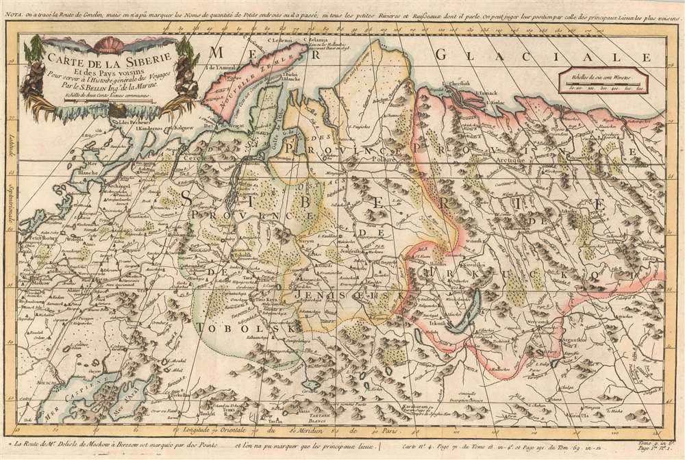
Carte de la Siberie et des Pays voisins.
1780 (undated) 12.25 x 18.25 in (31.115 x 46.355 cm) 1 : 14500000
1780 (undated) 12.25 x 18.25 in (31.115 x 46.355 cm) 1 : 14500000
Description
This is a 1780 Jacques-Nicolas Bellin map of Siberia. Depicting the region from Moscow and St. Petersburg to central Asia, numerous cities, towns, and villages are labeled. The region's rivers are illustrated in detail, along with its many mountain ranges.
Traced Voyages - Gmelin and De L'Isle.
Two routes are traced from western Russia east into Siberia. The first, and most consequential, follows the beginning of Johann Georg Gmelin's part of the Second Kamchatka Expedition, led by Vitus Bering. Gmelin left St. Petersburg in August 1733 and traveled through the Urals and western Siberia to Yeniseysk. On this expedition, Gmelin became the first person to scientifically prove that the Caspian Sea is, in fact, below the level of the Mediterranean. Gmelin finally reached Bering's headquarters in Yakutsk in September 1736, three years after he left St. Petersburg. The second expedition followed on this map is that of Nicoals De L'Isle, brother to the famed French cartographer Guillaume De L'Isle, between Moscow and Berezow. De L'Isle was in Russia working for the Imperial court as a cartographer, but we have been unable to find any details about this excursion from Moscow.Publication History and Census
Originally created for of Abbé Prévost's Histoire Générale des Voyages by Jacques-Nicolas Bellin, this map was published by Jean François de La Harpe's in his Abrégé de l'Histoire Générale des Voyages in 1780. Five examples of the 1780 edition of this map are cataloged in OCLC. They are part of the institutional collections at Brown University, Universitätsbibliothek München in Munich, Bayerische Staatsbibliothek, also in Munich, Universitätsbibliothek Bern, and the National Library of Poland. The works by Prévost and de la Harpe are well represented institutionally.Cartographer
Jacques-Nicolas Bellin (1703 - March 21, 1772) was one of the most important cartographers of the 18th century. With a career spanning some 50 years, Bellin is best understood as geographe de cabinet and transitional mapmaker spanning the gap between 18th and early-19th century cartographic styles. His long career as Hydrographer and Ingénieur Hydrographe at the French Dépôt des cartes et plans de la Marine resulted in hundreds of high quality nautical charts of practically everywhere in the world. A true child of the Enlightenment Era, Bellin's work focuses on function and accuracy tending in the process to be less decorative than the earlier 17th and 18th century cartographic work. Unlike many of his contemporaries, Bellin was always careful to cite his references and his scholarly corpus consists of over 1400 articles on geography prepared for Diderot's Encyclopedie. Bellin, despite his extraordinary success, may not have enjoyed his work, which is described as "long, unpleasant, and hard." In addition to numerous maps and charts published during his lifetime, many of Bellin's maps were updated (or not) and published posthumously. He was succeeded as Ingénieur Hydrographe by his student, also a prolific and influential cartographer, Rigobert Bonne. More by this mapmaker...
Source
De la Harpe, Abrégé de l'histoire générale des voyages. (Paris) 1780.
Condition
Very good. Exhibits some light offsetting.
References
OCLC 163340094.