1866 Mitchell Map of South America
SouthAmerica-mitchell-1866$100.00

Title
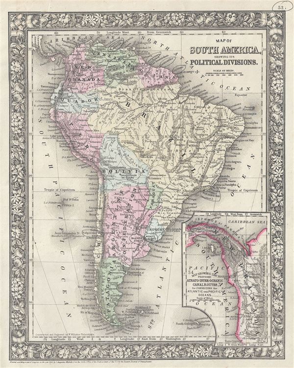
Map of South America, showing its Political Divisions.
1860 (dated) 14 x 11.5 in (35.56 x 29.21 cm) 1 : 27500000
1860 (dated) 14 x 11.5 in (35.56 x 29.21 cm) 1 : 27500000
Description
This is a fine example of the legendary American map publisher Samuel Augustus Mitchell Jr.'s 1866 map of South America. It depicts the whole continent from Panama to Cape Horn, it includes the Falkland and South Georgia island groups in considerable detail. Mitchell offers limited but surprisingly accurate detail of the interior of Brazil and the Amazon Basin. An inset map in the lower right quadrant depicts the Isthmus of Panama entitled 'Map Showing the Proposed Atrato-Inter-Oceanic Canal Routes, for Connecting the Atlantic and Pacific Oceans.' Work on the Panama Canal would begin in 1880 and be completed in 1914.
This map also identifies various cities, towns, rivers and an assortment of additional topographical details. Color coded according to political boundaries with elevation rendered by hachure. One of the more attractive American atlas maps of this region to appear in the mid-19th century. Prepared by S. A. Mitchell Jr. for inclusion as plate 53 in the 1866 issue of Mitchell's New General Atlas. Like many American map publishers of this period, Mitchell did not regularly update his copyright, consequently this map is dated and copyrighted to 1860: 'Entered according to Act of Congress in the Year 1860 by S. Augustus Mitchell Jr. in the Clerks Office of the District Court of the U.S. for the Eastern District of Pennsylvania.'
This map also identifies various cities, towns, rivers and an assortment of additional topographical details. Color coded according to political boundaries with elevation rendered by hachure. One of the more attractive American atlas maps of this region to appear in the mid-19th century. Prepared by S. A. Mitchell Jr. for inclusion as plate 53 in the 1866 issue of Mitchell's New General Atlas. Like many American map publishers of this period, Mitchell did not regularly update his copyright, consequently this map is dated and copyrighted to 1860: 'Entered according to Act of Congress in the Year 1860 by S. Augustus Mitchell Jr. in the Clerks Office of the District Court of the U.S. for the Eastern District of Pennsylvania.'
Cartographer
Samuel Augustus Mitchell (March 20, 1792 - December 20, 1868) began his map publishing career in the early 1830s. Mitchell was born in Bristol, Connecticut. He relocated to Philadelphia in 1821. Having worked as a school teacher and a geographical writer, Mitchell was frustrated with the low quality and inaccuracy of school texts of the period. His first maps were an attempt to rectify this problem. In the next 20 years Mitchell would become the most prominent American map publisher of the mid-19th century. Mitchell worked with prominent engravers J. H. Young, H. S. Tanner, and H. N. Burroughs before attaining the full copyright on his maps in 1847. In 1849 Mitchell either partnered with or sold his plates to Thomas, Cowperthwait and Company who continued to publish the Mitchell's Universal Atlas. By about 1856 most of the Mitchell plates and copyrights were acquired by Charles Desilver who continued to publish the maps, many with modified borders and color schemes, until Mitchell's son, Samuel Augustus Mitchell Junior, entered the picture. In 1859, S.A. Mitchell Jr. purchased most of the plates back from Desilver and introduced his own floral motif border. From 1860 on, he published his own editions of the New General Atlas. The younger Mitchell became as prominent as his father, publishing maps and atlases until 1887, when most of the copyrights were again sold and the Mitchell firm closed its doors for the final time. More by this mapmaker...
Source
Mitchell Jr., S. A., Mitchell's New General Atlas, Containing Maps Of The Various Countries Of The World, Plans Of Cities, Etc. Embraced In Forty-Seven Quarto Maps, Forming A Series Of Seventy-Six Maps And Plans, Together With Valuable Statistical Tables, 1866 edition.
Condition
Very good. Minor spotting. Pencil marks over some cities, can be erased.
References
Rumsey 0565.029 (1860 edition). Phillips (Atlases) 831-45. New York Public Library, Map Division, 1510824.