1751 Sayer View of Westminster Bridge and Abbey, London, England
SouthViewWestminster-sayer-1751$400.00

Title
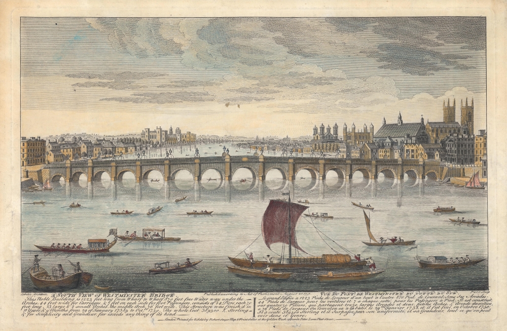
A South View of Westminster Bridge. / Vue du Pont de Westminster du cotte du sud.
1751 (dated) 9 x 15.25 in (22.86 x 38.735 cm)
1751 (dated) 9 x 15.25 in (22.86 x 38.735 cm)
Description
A hand-colored 1751 view of Westminster Bridge, Westminster Abbey, London. It was produced in the wake of the bridge's opening the previous year, which significantly alleviated traffic over existing bridges across the Thames River.
Westminster Bridge opened in 1750 and fulfilled a vital role supplementing London Bridge and Putney Bridge (also known as the Fulham Bridge) as the third centrally-located stone bridge across the Thames. Text below the view gives basic information on its length, width, number of piers, cost, and so on.
Several similar works were published around the time by various publishers, including Sayer, to celebrate the opening of the bridge by depicting it from different angles (and often printing both English and French text). This view should not be confused with an earlier (1746) work by the same title engraved by Thomas Jefferys for the Gentleman's Magazine. It is possible that the present work was influenced by Jefferys', but there are significant differences, most notably that Jefferys view is from the south, with Westminster Abbey at left, while the present work is oriented towards the south, with the abbey on the right. The present view is quite scarce, not appearing in the catalogs of any institution. The only other two known examples of this view employ the orientation of Jefferys with the title 'A North View of the Westminster Bridge,' making this a unique variation.
A Closer Look
Oriented towards the south, the view is dominated in its middle portion by the new bridge. In the foreground, ships of various sizes and types bustle about in the Thames. At right, the Palace of Westminster and Westminster Abbey stand out prominently, the latter's tall Western towers having also been recently completed after two centuries of planning and construction. Within the palace, St. Stephen's Chapel served as the meeting place of the House of Commons when this view was published. At left in the background is Lambeth Palace.Westminster Bridge opened in 1750 and fulfilled a vital role supplementing London Bridge and Putney Bridge (also known as the Fulham Bridge) as the third centrally-located stone bridge across the Thames. Text below the view gives basic information on its length, width, number of piers, cost, and so on.
Publication History and Census
This view was engraved by 'Parr,' likely Richard Parr (c.1707 - 1754), also known as Remi or Remigius Parr, not to be confused with another engraver named Richard Parr active in the 19th century. Parr may also refer to Nathaniel Parr, a contemporary engraver. The view also credits Charles Paul Labelye (1705 - 1761) (here as Labelie), the Swiss-born engineer who designed the bridge. It was printed by Robert Sayer in 1751.Several similar works were published around the time by various publishers, including Sayer, to celebrate the opening of the bridge by depicting it from different angles (and often printing both English and French text). This view should not be confused with an earlier (1746) work by the same title engraved by Thomas Jefferys for the Gentleman's Magazine. It is possible that the present work was influenced by Jefferys', but there are significant differences, most notably that Jefferys view is from the south, with Westminster Abbey at left, while the present work is oriented towards the south, with the abbey on the right. The present view is quite scarce, not appearing in the catalogs of any institution. The only other two known examples of this view employ the orientation of Jefferys with the title 'A North View of the Westminster Bridge,' making this a unique variation.
Cartographer
Robert Sayer (1725 - January 29, 1794) was an important English map publisher and engraver active from the mid to late 18th century. Sayer was born in Sunderland, England, in 1725. He may have clerked as a young man with the Bank of England, but this is unclear. His brother, James Sayer, married Mary Overton, daughter-in-law of John Overton and widow of Philip Overton. Sayer initially worked under Mary Overton, but by December of 1748 was managing the Overton enterprise and gradually took it over, transitioning the plates to his own name. When Thomas Jefferys went bankrupt in 1766, Sayer offered financial assistance to help him stay in business and, in this way, acquired rights to many of the important Jefferys map plates as well as his unpublished research. From about 1774, he began publishing with his apprentice, John Bennett (fl. 1770 - 1784), as Sayer and Bennett, but the partnership was not formalized until 1777. Bennett retired in 1784 following a mental collapse and the imprint reverted to Robert Sayer. From 1790, Sayer added Robert Laurie and James Whittle to his enterprise, renaming the firm Robert Sayer and Company. Ultimately, Laurie and Whittle partnered to take over his firm. Sayer retired to Bath, where, after a long illness, he died. During most of his career, Sayer was based at 53 Fleet Street, London. His work is particularly significant for its publication of many British maps relating to the American Revolutionary War. Unlike many map makers of his generation, Sayer was a good businessman and left a personal fortune and great estate to his son, James Sayer, who never worked in the publishing business. More by this mapmaker...
Condition
Very good. Areas of discoloration, mostly in the margins. Creasing and repaired damage in left and bottom margin.