1851 Wyld 'Gold Rush' Map of Southeast Australia: New South Wales, Victoria
SoutheastAustralia-wyld-1851$900.00

Title
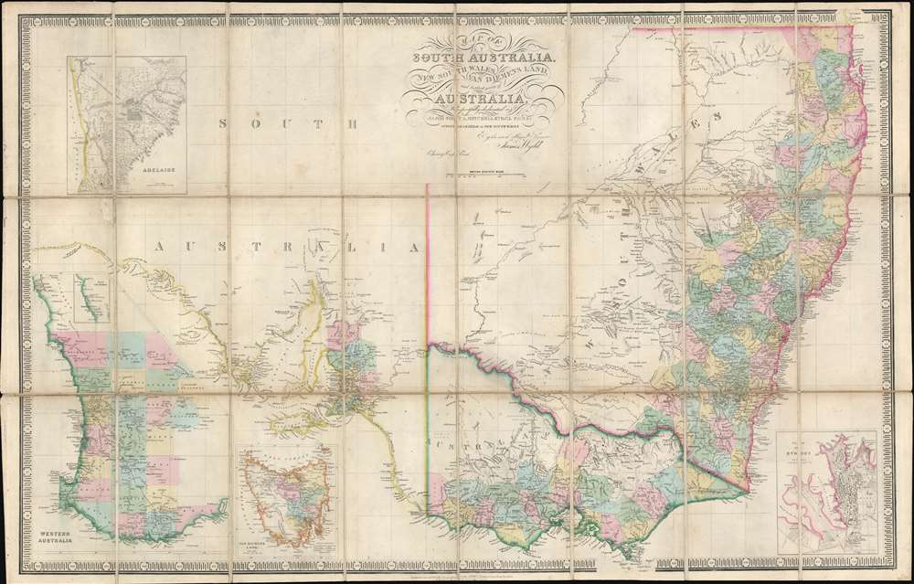
Map of South Australia, New South Wales, Van Diemens Land, and Settled parts of Australia.
1851 (undated) 25 x 39 in (63.5 x 99.06 cm) 1 : 3000000
1851 (undated) 25 x 39 in (63.5 x 99.06 cm) 1 : 3000000
Description
An exceptional c. 1851 James Wyld map of southeastern Australia, Tasmania (Van Diemen's Land), New South Wales, and Western Australia, issued to capitalize on the 1851 Australian Gold Rush. Probably the finest map of Australia then extant, the map draws heavily on the explorations of Sir Thomas Livingstone Mitchell (June 15, 1792 - October 5, 1855), an influential surveyor and explorer to whom the map is also dedicated. Mitchell led a series of expeditions throughout south-eastern Australia between 1830 and 1836.
Coverage
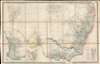
Following on Mitchell's discoveries, the map covers southeastern Australia from Wide Bay on the east coast north of Sydney to the Great Australian Bight near Point Fowler and Fowlers Bay - covering New South Wales, Victoria, Tasmania, and Western Australia. Coverage extends inland as far as the Darling River - representing the farthest extent of Mitchell's explorations. Inset maps detail Sydney and Adelaide in considerable detail. Other insets, in the lower left quadrant, focus on Western Australia and Tasmania (Van Diemen's Land). In the settled coastal regions, where extensive survey work took place, the region is divided into counties.Australian Gold Rush of 1851
Gold was known to be present in Australia prior to 1851, but the intentional suppression of this information by the colonial government of New South Wales prevented all-out gold rushes. When gold was discovered at Sutter's Mill, California, in 1848, causing the California Gold Rush, countless Australians migrated in search of their fortunes. Desirous of maintaining their dwindling work force, the colonial governors rethought their position, and sought approval from the Colonial Office in England to allow the exploitation of the mineral resources and also offered rewards for the finding of payable gold. This led to the first major Australian gold rush when prospector Edward Hargraves discovered gold at Ophir, near Orange. A series of subsequent discoveries followed, transforming the Australian economy and leading to a rush of new immigration.Publication History and Census
This map proved popular due to general interest in the region associated with the 1851 gold strikes. It went through multiple editions, often with slightly variant titles - and accordingly at high zoom there are considerable indications of erased and revised content. The earliest known variant of this map is dates to 1839, based on an advertisement in a history of South Australia published in that year. Updated reprints continued to be issued well into the 1850s. The present edition mentions Wyld's great globe (60 feet in diameter) in Leicester Square, which means it was must have been issued between 1851 and 1862 - when the globe was standing. In addition, it references the Charing Cross East address, where Wyld maintained offices from 1837 to 1852. Thus, this map could be issued no earlier than 1851, and no later than 1852. This map most commonly appears uncolored, with the 1851- 1852 edition commonly receiving full color treatment, as here, likely due to increased Gold Rush Era interest in the region. Of all editions, the present Gold Rush example is the most desirable due to its historical significance and elegant deluxe treatment.Cartographer
Wyld (1823 - 1893) was a British publishing firm active throughout the 19th century. It was operated by James Wyld I (1790 - 1836) and his son James Wyld II (November 20, 1812 - 1887) were the principles of an English mapmaking dynasty active in London during much of the 19th century. The elder Wyld was a map publisher under William Faden (1749 - 1836) and did considerable work on the Ordinance Survey. On Faden's retirement in 1823, Wyld took over Faden's workshop, acquiring many of his plates. Wyld's work can often be distinguished from his son's maps through his imprint, which he signed as 'Successor to Faden'. Following in his father's footsteps, the younger Wyld joined the Royal Geographical Society in 1830 at the tender age of 18. When his father died in 1836, James Wyld II was prepared to fully take over and expand his father's considerable cartographic enterprise. Like his father and Faden, Wyld II held the title of official Geographer to the Crown, in this case, Queen Victoria. In 1852, he moved operations from William Faden's old office at Charing Cross East (1837 - 1852) to a new, larger space at 475 Strand. Wyld II also chose to remove Faden's name from all of his updated map plates. Wyld II continued to update and republish both his father's work and the work of William Faden well into the late 1880s. One of Wyld's most eccentric and notable achievements is his 1851 construction of a globe 19 meters (60 feet) in diameter in the heart of Leicester Square, London. In the 1840s, Wyld also embarked upon a political career, being elected to parliament in 1847 and again in 1857. He died in 1887 following a prolific and distinguished career. After Wyld II's death, the family business was briefly taken over by James John Cooper Wyld (1844 - 1907), his son, who ran it from 1887 to 1893 before selling the business to Edward Stanford. All three Wylds are notable for producing, in addition to their atlas maps, short-run maps expounding upon important historical events - illustrating history as it was happening - among them are maps related to the California Gold Rush, the New South Wales Gold Rush, the Scramble for Africa, the Oregon Question, and more. More by this mapmaker...
Condition
Very good. Some toning. Dissected and mounted on linen. Original linen stable.
References
OCLC 221753763. Library of Congress, Map Division, G9010 1850 .W9.