1953 Highway Strip Map of St. Johns River Trail, Florida
StJohnsRiverTrail-trailassoc-1953$200.00


Title
St. Johns River Trail : The Inland Route to Miami.
1953 (undated) 17.75 x 4 in (45.085 x 10.16 cm) 1 : 2850000
1953 (undated) 17.75 x 4 in (45.085 x 10.16 cm) 1 : 2850000
Description
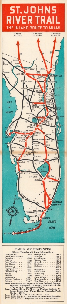
This classic c. 1953 highway association strip map promotes Florida's St. Johns River Trail, 'the inland route to Miami.' It was produced early in Florida's post-WWII population and tourism boom, which quickly necessitated new highway infrastructure.
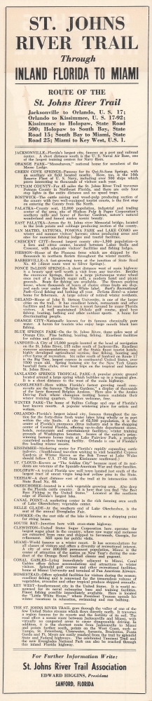
The highways that form the trail are highlighted in red here, while additional highways are noted in black. Cities, lakes, rivers, and landmarks (such as Everglades National Park and the University of Florida) are indicated. At bottom, a table of distances notes the mileage between Jacksonville and other towns and cities along the trail's routes, which are discussed in short, promotional descriptions on the verso.
The St. Johns River Trail was intended to accomplish two tasks: alleviating demand on the popular coastal route (U.S. 1), billing itself as the faster and more scenic of the two, and providing access and business to growing inland towns and cities. In the following decades, these routes were supplemented by the Florida Turnpike and Interstate-95.
A Closer Look
Rather than a single highway, the St. Johns Trail combined multiple highways (especially U.S. 17 and FL 15) that offered an inland connection between the state's north and south. Some of these highways did not exist, or did not exist as highways, when the association was founded c. 1940, and highways were added to the trail as they were completed or planned throughout the 1940s and early 1950s.The highways that form the trail are highlighted in red here, while additional highways are noted in black. Cities, lakes, rivers, and landmarks (such as Everglades National Park and the University of Florida) are indicated. At bottom, a table of distances notes the mileage between Jacksonville and other towns and cities along the trail's routes, which are discussed in short, promotional descriptions on the verso.
The St. Johns River Trail was intended to accomplish two tasks: alleviating demand on the popular coastal route (U.S. 1), billing itself as the faster and more scenic of the two, and providing access and business to growing inland towns and cities. In the following decades, these routes were supplemented by the Florida Turnpike and Interstate-95.
Highway Associations
The movement promoting the construction of 'good quality' roads did not begin with the invention of the automobile, but rather with the bicycle. At the time, most interurban roads were unpaved and impractical for cycling. The 'Good Roads Movement' was inaugurated in May 1880 to advocate for bicycle enthusiasts, riding clubs, and manufacturers. By 1910, the American Automobile Association (AAA) jumped onboard, along with over one hundred other local and national organizations. 'Road booster' organizations emerged to promote specific, often branded, highways. By the 1920s, about 250 'named' highways, each with their own boosters, crossed the United States. 'Road boosters' still exist, but most disbanded in the 1950s and 60s with the emergence of the federally funded Interstate Highway System.Publication History and Census
This strip map was produced by the St. Johns River Trail Association. It is undated but from context must have been printed around 1953. The only known example of this map in institutional collections is held by the University of Florida. An earlier edition dated c. 1942 is also held by the Tampa Bay History Center's Touchton Map Library.Source
Scuola Italiana Moderna, No. 6, (Italy) November 1957.
Condition
Good. Wear and discoloration along fold lines.
References
OCLC 929909999. Tampa Bay History Center Touchton Map Library 2019.102.024 (c. 1942 edition).