1780 Bellin Map of St. Christopher/ St. Kitts
StKitts-bellin-1780$350.00
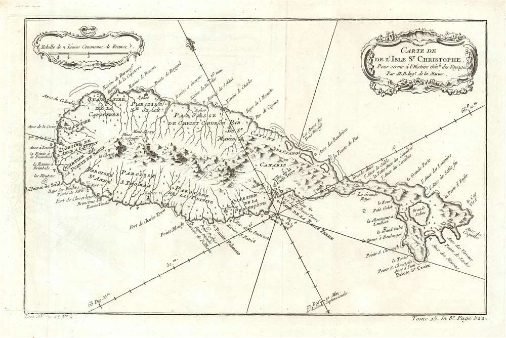

Title
Carte De De l'Isle St. Christophe Pour servir á l'Histoire Genle. des Voyages Par M. B. Ingr. de la Marine.
1780 (undated) 8 x 12.25 in (20.32 x 31.115 cm) 1 : 78000
1780 (undated) 8 x 12.25 in (20.32 x 31.115 cm) 1 : 78000
Description
This is an attractive 1780 Bellin map of the Caribbean island of St. Christopher/ St. Kitts. The map is based on the surveys of Andrew Norwood, who died nearly a century prior in 1685. Norwood's survey also served as source material the maps of Moll, Bowen, and Mount and Page. During the course of the 17th century, the island saw the establishment of colonies by the English (1623) and the French (1625). The two colonial powers vied for dominance, cooperating only in the massacre of the indigenous Kalinago population, and interrupted only for a year by the 1629 Spanish occupation. Thereafter, the English and French partitioned the island, and it changed hands several times by both military action and treaty. By the time this map was printed, rule of the island passed to the British according to the terms of the Peace of Utrecht - although the place names reflect the French tenure on the eastern part of the island.
Publication History and Census
The map was executed in 1757 for inclusion in Prévost's Histoire générale des voyages, and was again printed in 1780 for Harpe's abridged edition of that work, one perhaps better known for its imaginative flourish than for its factuality. This map appears on the market from time to time, although OCLC only lists four or five copies of the separate map in this edition, though inconsistencies in cataloguing mean this number may be higher. Prévost's Histoire and Harpe's abridged version of it are well represented in institutional collections.Cartographer
Jacques-Nicolas Bellin (1703 - March 21, 1772) was one of the most important cartographers of the 18th century. With a career spanning some 50 years, Bellin is best understood as geographe de cabinet and transitional mapmaker spanning the gap between 18th and early-19th century cartographic styles. His long career as Hydrographer and Ingénieur Hydrographe at the French Dépôt des cartes et plans de la Marine resulted in hundreds of high quality nautical charts of practically everywhere in the world. A true child of the Enlightenment Era, Bellin's work focuses on function and accuracy tending in the process to be less decorative than the earlier 17th and 18th century cartographic work. Unlike many of his contemporaries, Bellin was always careful to cite his references and his scholarly corpus consists of over 1400 articles on geography prepared for Diderot's Encyclopedie. Bellin, despite his extraordinary success, may not have enjoyed his work, which is described as "long, unpleasant, and hard." In addition to numerous maps and charts published during his lifetime, many of Bellin's maps were updated (or not) and published posthumously. He was succeeded as Ingénieur Hydrographe by his student, also a prolific and influential cartographer, Rigobert Bonne. More by this mapmaker...
Source
De la Harpe, Abrégé de l'histoire générale des voyages. (Paris) 1780.
Condition
Excellent condition with generous margins.
References
OCLC 5411806.