Digital Image: 1948 Blanton Pictorial Map of Brunswick and St. Simons Island, Georgia
StSimonsIslandGA-blanton-1948_d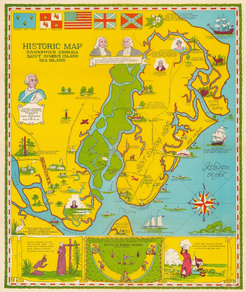

Title
Historic Map Brunswick Georgia Saint Simons Island Sea Island.
1948 (undated) 15.5 x 12.75 in (39.37 x 32.385 cm)
1948 (undated) 15.5 x 12.75 in (39.37 x 32.385 cm)
Description
FOR THE ORIGINAL ANTIQUE MAP, WITH HISTORICAL ANALYSIS, CLICK HERE.
Digital Map Information
Geographicus maintains an archive of high-resolution rare map scans. We scan our maps at 300 DPI or higher, with newer images being 600 DPI, (either TIFF or JPEG, depending on when the scan was done) which is most cases in suitable for enlargement and printing.
Delivery
Once you purchase our digital scan service, you will receive a download link via email - usually within seconds. Digital orders are delivered as ZIP files, an industry standard file compression protocol that any computer should be able to unpack. Some of our files are very large, and can take some time to download. Most files are saved into your computer's 'Downloads' folder. All delivery is electronic. No physical product is shipped.
Credit and Scope of Use
You can use your digial image any way you want! Our digital images are unrestricted by copyright and can be used, modified, and published freely. The textual description that accompanies the original antique map is not included in the sale of digital images and remains protected by copyright. That said, we put significant care and effort into scanning and editing these maps, and we’d appreciate a credit when possible. Should you wish to credit us, please use the following credit line:
Courtesy of Geographicus Rare Antique Maps (https://www.geographicus.com).
How Large Can I Print?
In general, at 300 DPI, you should at least be able to double the size of the actual image, more so with our 600 DPI images. So, if the original was 10 x 12 inches, you can print at 20 x 24 inches, without quality loss. If your display requirements can accommodate some loss in image quality, you can make it even larger. That being said, no quality of scan will allow you to blow up at 10 x 12 inch map to wall size without significant quality loss. For more information, it is best consult a printer or reprographics specialist.
Refunds
If the high resolution image you ordered is unavailable, we will fully refund your purchase. Otherwise, digital images scans are a service, not a tangible product, and cannot be returned or refunded once the download link is used.
Cartographer S
Virginia Tison (Hilsman) Blanton (May 15, 1897 - February 22, 1983) was an American artist and housewife. Born in Macon, Georgia, Blanton attended the University of Georgia and studied art in New York City. Blanton is credited with making at least three pictorial maps of coastal Georgia, one of which she composed with her son Jacob A. Blanton, Jr. She married Jacob A. Blanton, and they lived on St. Simons Island and had 2 children. Jacob A. Blanton, Sr. died September 25, 1951. More by this mapmaker...
Jacob Alexander Blanton, Jr. (September 17, 1921 - July 9, 2013) was an American pilot and artist. Born in Brunswick, Georgia, Blanton attended the Georgia Institute of Technology for 2 years before volunteering for the U.S. Army Air Force and serving for 7 years, including fighting in World War II. After leaving the service, Blanton returned to Georgia Tech and earned a degree in mechanical engineering in June 1951. After graduating, Blanton worked as a commercial pilot for Eastern Airlines before moving to Lockheed Martin, where he worked as a mechanical engineer. He retired from Lockheed Martin in 1987. Blanton is credited with creating at least one map, a pictorial map of St, Simons Island, which me made with his mother, Virginia Blanton. He met his wife, Anne Davis Moore, at Georgia Tech, and they married not long after Blanton graduated in June 1951. They had 2 daughters. Learn More...
References
OCLC 12413645.