This item has been sold, but you can get on the Waitlist to be notified if another example becomes available, or purchase a digital scan.
1838 Land Survey Map of Missouri
StateOfMissouri-landsurvey-1838$100.00

Title
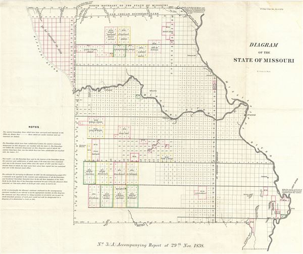
Diagram of the State of Missouri.
1838 (dated) 18.5 x 23 in (46.99 x 58.42 cm) 1 : 1200000
1838 (dated) 18.5 x 23 in (46.99 x 58.42 cm) 1 : 1200000
Description
This is an impressive example of the 1838 public survey map of Missouri W. J. Stone. It covers the entire state of Missouri from the Mississippi River to the Missouri River. The map was prepared to illustrate the progress of the land survey work in Missouri, noted via a series of blocks representing the survey grid. Notes in the bottom left quadrant describe the various markings on the map. The towns of Fayette, Jefferson, Jackson, St. Louis, Springfield, Lexington and Palmyra are identified. The Indian boundary line as well as the north boundary of Missouri as determined by the State Commissioners in 1837 is noted. The map also notes important rivers, lakes, towns, swamps and other topography throughout. This map was issued by the General Land Office as No. 3 (A) accompanying the report of 29th Nov. 1838.
Cartographer
The General Land Office (1812 - 1946) was an independent agency charged with the administration and sale of public lands of the western territories of the United States under the Preemption Act of 1841 and the Homestead Act of 1862. During a time of frenetic energy and rapid westward expansion, the Land Office oversaw the surveying, platting, mapping and eventually the sale of much of the Western United States and Florida. The structural layout of the western United States that we see today, and many of their district and county divisions, are direct result of the early surveying work of the General Land Office. More importantly, as a branch of the Federal Government in Washington D.C. and the only agency able to legally sell and administer public lands in the western territories of the United States, the General Land Office played a pivotal role in consolidating power away from the original states and into the hands of the centralized federal government. The General Land Office was absorbed into the Department of Interior in 1849 and in 1946 merged with the United States Grazing Service to become the Bureau of Land Management. Today the Bureau of Land Management administers the roughly 246 million acres of public land remaining under federal ownership. More by this mapmaker...
Source
Report of the Surveyor General, (1838 issue)
Condition
Very good. Minor wear and toning along original fold lines. Minor spotting. Professionally flattened and backed with archival tissue.