This item has been sold, but you can get on the Waitlist to be notified if another example becomes available, or purchase a digital scan.
1952 U.S. Air Force Aeronautical Map of the Sulu Archipelago, Philippines
SuluArchipelago-usaf-1952$50.00

Title
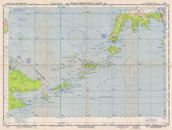
Sulu Archipelago North Borneo-Philippines.
1952 (dated) 22 x 29 in (55.88 x 73.66 cm) 1 : 1000000
1952 (dated) 22 x 29 in (55.88 x 73.66 cm) 1 : 1000000
Description
This is a scarce 1952 U.S. Air Force aeronautical chart or map of the Sulu Archipelago in southwestern Philippines. It covers the archipelago forming the southern limit of the Sulu Sea and the northern limit of the Celebes Sea and includes the islands of the Sibutu Group, the Tawi Tawi Group, the Tapul Group, Pangutaran Group, the Jolo Group, the Samales Group, the Tapiantana Group and the Pilas Group. Also includes the northern part of the island of Borneo and the Zamboanga Peninsula of Mindanao. The chart is highly detailed and notes towns, cities, roads, rivers, topography and other data essential to the air pilot. Verso features legends and a world aeronautical chart index. This chart was published by the Aeronautical Chart Service, Washington D.C., and issued as chart no. 856. First issued in 1948, this is the fifth edition revised to Sept 1952.
Condition
Very good. Minor wear and toning along original fold lines. Minor spotting.