This item has been sold, but you can get on the Waitlist to be notified if another example becomes available, or purchase a digital scan.
1929 Transcontinental Air Transport Pictorial Map of the United States
TATPictorial-randmcnally-1929$500.00


Title
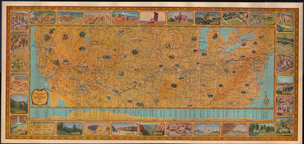
Illustrated Map of the Route of Transcontinental Air Transport, Inc.
1929 (dated) 14.5 x 31.25 in (36.83 x 79.375 cm) 1 : 5500000
1929 (dated) 14.5 x 31.25 in (36.83 x 79.375 cm) 1 : 5500000
Description
This is a 1929 Rand McNally and Transcontinental Air Transport pictorial map of the United States highlighting the inauguration of Transcontinental's cross-country service. Combining air and rail service, the TAT 'Coast to Coast' route was the first cross-country air-passenger route. This piece was a memento presented to travelers boarding the airplane. An example even appeared in Transcontinental's 1929 film promoting the revolutionary route, 'Coast to Coast in 48 Hours'.
A Closer Look
Purple lines trace air segments, while black lines detail overnight railroad segments. The air segments connected cities where the plane paused for refueling, and passengers could disembark for short periods. Vignette views highlight sights encountered en route, including Arches National Park, livestock, farming, etc. A profile view of the terrain covered appears below the map, presenting the vastness and diversity of the country. The whole is surrounded by a pictorial border populated by aerial views of cities and natural wonders.A Fine Souvenir
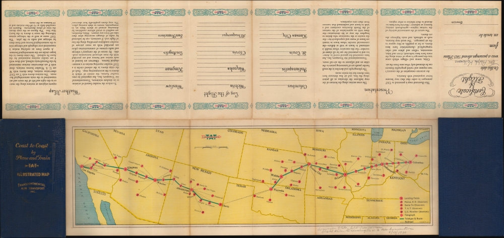
Contained within blue binders, this map was intended to make an impression on Transcontinental's passengers. A stripped-down route map occupies the top portion of the verso, offering a more straightforward overview of the trip. The bottom portion of the verso contained places for travelers to note impressions of each city visited (even though they only saw the air terminal).An Expensive and Luxurious Trip
Passengers traveling with Transcontinental in 1929 paid roughly $350 one way. That equates to around $5,700 in 2021 - truly a first-class experience! The Ford Trimotor was the first airplane constructed for commercial passenger travel. Prior to the late 1920s, American Airlines focused on government air mail contracts over passenger transport. The transition to passenger flights was a major moment in aviation history, making long-distance travel accessible at a speed never before imagined.Transcontinental Air Transport - TWA
Transcontinental Air Transport, known as TAT, was an American airline founded in 1928 by Clement Melville Keys. Charles Lindbergh, the famous aviator remembered for his transatlantic flight, designed the airline's passenger network. He established airports across the country to service transcontinental flights. Transcontinental merged with Maddux Air Lines in 1929 and with Western Air Express in 1930. The merger with Western Air Express formed Transcontinental and Western Air. The partnership fell apart in 1934 when Western split off. Nonetheless, Transcontinental kept the 'Transcontinental and Western Air' name, eventually becoming Trans World Airlines, or TWA.Publication History and Census
This map was created and published by Rand McNally for Transcontinental Air Transport Inc. While well represented in institutional collections, possibly due to an instant recognition of its significance, it is scarce on the private market.Cartographer
Rand, McNally and Co. (fl. 1856 - present) is an American publisher of maps, atlases and globes. The company was founded in 1856 when William H. Rand, a native of Quincy, Massachusetts, opened a print shop in Chicago. Rand hired the recent Irish immigrant Andrew McNally to assist in the shop giving him a wage of 9 USD per week. The duo landed several important contracts, including the Tribune's (later renamed the Chicago Tribune) printing operation. In 1872, Rand McNally produced its first map, a railroad guide, using a new cost effective printing technique known as wax process engraving. As Chicago developed as a railway hub, the Rand firm, now incorporated as Rand McNally, began producing a wide array of railroad maps and guides. Over time, the firm expanded into atlases, globes, educational material, and general literature. By embracing the wax engraving process, Rand McNally was able to dominate the map and atlas market, pushing more traditional American lithographic publishers like Colton, Johnson, and Mitchell out of business. Eventually Rand McNally opened an annex office in New York City headed by Caleb S. Hammond, whose name is today synonymous with maps and atlases, and who later started his own map company, C. S. Hammond & Co. Both firms remain in business. More by this mapmaker...
Condition
Very good. Light wear along original fold lines. Attached to original boards. Text and Transcontinental Air Transport route map on verso.
References
Rumsey 3704.002. OCLC 55796523.