1769 Bellin Map of Tahiti
Tahiti-bellin-1769$200.00
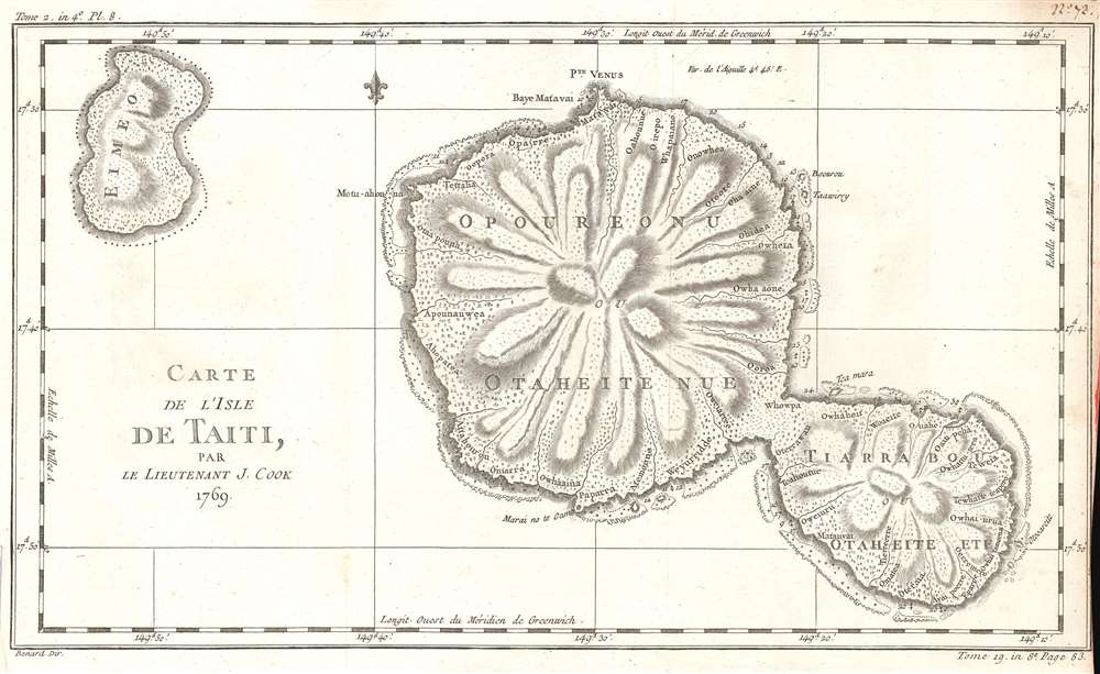

Title
Carte de l'Isle de Taiti, Par le Lieutenant J. Cook.
1769 (undated) 10 x 16 in (25.4 x 40.64 cm) 1 : 240000
1769 (undated) 10 x 16 in (25.4 x 40.64 cm) 1 : 240000
Description
This is a 1769 Jacques-Nicolas Bellin map of Tahiti in French Polynesia. The map depicts both Tahiti and Mo'orea. Created by Bellin from James Cook's charts of the island from his first voyage, numerous locations are identified. Depth soundings are noted around the island's coastline, and small trees and topography are also illustrated throughout.
This map was created by Jacques-Nicolas Bellin for inclusion in Abbé Prévost's Histoire Générale des Voyages.
This map was created by Jacques-Nicolas Bellin for inclusion in Abbé Prévost's Histoire Générale des Voyages.
Cartographer
Jacques-Nicolas Bellin (1703 - March 21, 1772) was one of the most important cartographers of the 18th century. With a career spanning some 50 years, Bellin is best understood as geographe de cabinet and transitional mapmaker spanning the gap between 18th and early-19th century cartographic styles. His long career as Hydrographer and Ingénieur Hydrographe at the French Dépôt des cartes et plans de la Marine resulted in hundreds of high quality nautical charts of practically everywhere in the world. A true child of the Enlightenment Era, Bellin's work focuses on function and accuracy tending in the process to be less decorative than the earlier 17th and 18th century cartographic work. Unlike many of his contemporaries, Bellin was always careful to cite his references and his scholarly corpus consists of over 1400 articles on geography prepared for Diderot's Encyclopedie. Bellin, despite his extraordinary success, may not have enjoyed his work, which is described as "long, unpleasant, and hard." In addition to numerous maps and charts published during his lifetime, many of Bellin's maps were updated (or not) and published posthumously. He was succeeded as Ingénieur Hydrographe by his student, also a prolific and influential cartographer, Rigobert Bonne. More by this mapmaker...
Condition
Very good. Even overall toning. Slight loss along bottom right border. Blank on verso.
References
OCLC 707615013.