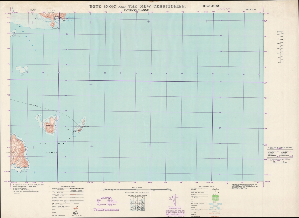
A large-format 1949 survey map of the coasts, islands, and waters in the Tathong Channel off the eastern coast of Hong Kong Island, produced by the British War Office.
A Closer Look
The Tathong Channel (大東門 'Great East Gate') is the main route for ships navigating around the eastern side of Hong Kong Island to enter Victoria Harbour. It leads into Junk Bay (Tseung Kwan O) and then to the narrow channel of Lei Yue Mun before reaching the main and busiest portion of Victoria Harbour.
Aside from Tathong Point on the south side of Tung Lung Chau, Sam Kong (Sung Kong) and the Wanglan Islands appear in their entirety, with portions of Po Toi. As can be seen here, Wanglan was home to a lighthouse connected with Hong Kong Island by an underwater cable; soon after this map's publication, a weather station was also established on Wanglan.
Though not primarily a nautical chart, fathoms, hazards, shoals, and other maritime features are also noted. The purple grid overlying the map corresponds to a World Polyconic Projection using the U.S. Yard Grid system, developed for the 'Southwest Pacific' region during World War II by modifying a pre-existing British grid system.Historical Context
This map was one part of a 24-sheet survey map series of Hong Kong, first undertaken in 1929 - 1930 and updated periodically thereafter. This ambitious undertaking was no doubt one of the largest, if not the largest, topographical surveys of Hong Kong at the time. The updates made after the Second World War (2nd and 3rd editions) were no doubt motivated by taking stock after the city's occupation by the Japanese. But the third edition in 1949 also coincides with the Communist revolution in mainland China, which presented a serious threat to the colony.
The United Kingdom was the earliest Western power to recognize the People's Republic of China, in January 1950, in a bid to protect Hong Kong. Still, it was not at all clear that Hong Kong would be safe from a Communist invasion, and Britain was hardly in a position to try to defend the colony at the time. We now know that part of the reason the Communists left Hong Kong alone is because it served a vital function as a window to the capitalist world, allowing, for instance, the evasion of a U.S. blockade to receive critical supplies during the Korean War. Though tens of thousands of refugees fled the mainland for Hong Kong in the late 1940s, the border between Hong Kong and 'red' China was quite open in the early-mid 1950s, allowing Hong Kong residents to travel to their home villages and visit relatives. Though this 'travel,' often an excuse for trading, was a thorn in the side of the Communists, who were attempting to institute a strict customs regime and control the flow of precious metals to support the renminbi, it also was an economic boon, especially to Guangdong and Fujian provinces.Publication History and Census
This map was initially produced by the British War Office in 1929 incorporating surveys undertaken by the Royal Engineers. Minor corrections were added in 1939, a second edition was produced in 1945, and this third edition appeared in 1949, with assistance from the Ordnance Survey (subsequent editions were produced in 1952, 1957, and 1969). This is the 24th Sheet in a series of 24 (a diagram of the full survey is included at bottom-center). The complexities of dating the map make establishing a precise census difficult. Only the Hong Kong Baptist University and the University of Hong Kong clearly hold examples of this edition of the map, while the National Library of Australia holds the entire series, but with individual maps from different editions which are not clearly indicated in the catalog listing.
CartographerS
The British War Office (1857 - 1964) was a department of the British Government responsible for the administration of the Royal Army until 1964, when its functions were transferred to the Ministry of Defense. The War Office was to the Royal Army what the Admiralty was to the Royal Navy, and later, the Air Ministry. Within the War Office, the General Staff Topographical Section was responsible for thousands of maps issued for British intelligence and military use. The Topographical Section was renamed Geographical Section in April 1907. Many, once their military use passed, were offered through licensed agents to the general public. The sole London agent for War Office material was Edward Stanford. More by this mapmaker...
The British Ordnance Survey (1791 - present) is the national mapping agency of Great Britain and is one of the largest producers of maps in the world. This non-ministerial department of the government of the United Kingdom is responsible for producing maps of Great Britain and many of its overseas possessions. The history of the Ordnance Survey goes back as far as 1747, following the Jacobite rising, when King George II commissioned a comprehensive military survey of Scotland to assist further campaigns. The result, produced by Paul Sandby, John Mason and William Roy, was the Duke of Cumberland's Map, the first military quality map of the British Isles. This grew into the Principal Triangulation of Great Britain (1783-1853) under William Roy, and eventually lead to the creation of the Ordnance Survey in 1791. Today the Ordnance Survey produces a large variety of paper maps and digital mapping products. Its large scale maps, issued to the scale of 1:10000, available in sheet map form until the 1980s, are now only available digitally. All maps produced by the Ordnance Survey are in copyright for 50 years after publication. Learn More...
Very good.
OCLC 49354954.