1845 Farnham / Morse Maps of the Republic of Texas and Upper California
TexasCalifornia-farnhammorse-1845$750.00

Title
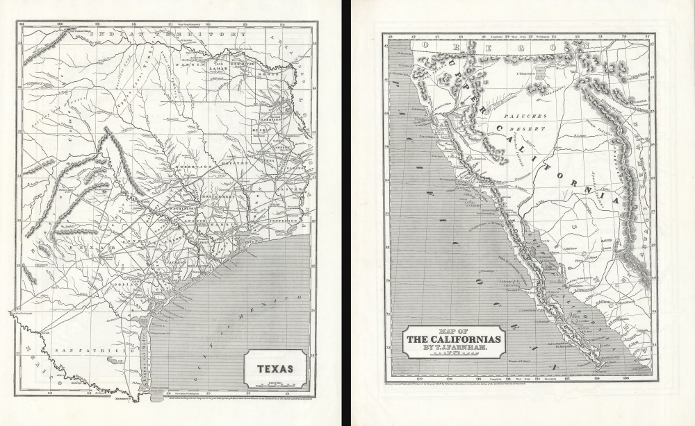
Texas. / Map of The Californias by T.J. Farnham.
1845 (dated) 16 x 13 in (40.64 x 33.02 cm) 1 : 2500000
1845 (dated) 16 x 13 in (40.64 x 33.02 cm) 1 : 2500000
Description
Maps of the Republic of Texas and Upper California in 1845, issued for Sidney E. Morse's Cerographic Atlas. The maps are printed back-to-back, but collectively represent the region in the year prior to the outbreak of the Mexican-American War (1846 - 1848), in the final days of the Republic of Texas (1836 - 1846) and Mexican California, considered the first atlas map of Upper California.
Texas
The Texas map (1:2,450,000) covers from the Rio Grande to the Red River and from the Wichita Mountains to the Sabine River. The map exhibits an early county structure in east Texas. The sites of several battles are noted, inkling the Alamo in San Antonio and 'Fannings Battle' in Goliad County.Republic of Texas
The Republic of Texas was a short-lived nation established in March 1836 when it seceded from Mexico. Following the independence of Mexico from Spain, the American Stephen Fuller Austin led a group of 300 Empresarios to settle Texas, near Austin, where they received a grant from the Mexican government. As more Americans moved to Texas, resentment and strife began to build between the American settlers and Mexican authorities. This and other factors ultimately led to the Texan Revolution in 1835 and the declaration of Texan independence in 1836. Texas remained an independent republic until it joined the United States ten years later in 1846.Map of the Californias by T. J. Farnham
This map (1:3400000) is significant as the first atlas map of Upper California, issued in the leadup to the Mexican-American War. Coverage embraces from Cabo San Lucas and Mazatlan to the Oregon Border, and from the Pacific to Santa Fe. Both the Mission of San Francisco and the Mexican settlement of Yerba Buena are labeled, as are San Jose, Santa Clara, and Santa Cruz, among other sites. OF significant Sutter's Colony (Sutter is in a pre-Anglicized form 'Suter') on the Sacramento River. The overland route runs east, directly across the Great Basin to pass north of Great Salt Lake (L. Timpanigos). The cartography is heavily influence by the voyage of Thomas Jefferson Farnham.Thomas Jefferson Farnham
Thomas Jefferson Farnam (1804 - 1848), a lawyer by trade, led an ambitious 1839 expedition to Oregon and California. Known as the Peoria Party Expedition, it conceived with a dual mission: 'to raise the American flag and run the Hudson's Bay Company out of the country'. Farnham was elected as the group leader and his wife, Eliza Woodson Burhams, crafted the expedition flag, bearing the rallying cry: 'Oregon or the Grave!' The unity of the expedition was tested when the group split at Bent's Fort. Thereafter, guided by Capt. Hall J. Kelly, they navigated to Fort Davy Crockett situated at Brown's Hole on the Green River (here labeled). Their journey continued to Fort Hall before finally reaching Oregon. Farnham then ventured further south into California, where he boarded a ship heading back east. He returned to California in 1856. There, two years later in San Francisco, he died. Farnham's widow Eliza moved to Santa Cruz, California and became a leading abolitionist, novelist, and early feminist.Publication History and Census
The Texas map was engraved in 1844, and the Californias map in 1845, both likely by J. N. Nicollet. Texas bears the Sidney E. Morse and Samuel Breese imprint, but the California map is copyrighted to 'Thomas J. Farnham'. Both maps appear in the 1845 edition of Morse and Breese's Cerographic Atlas of the United States - the first atlas printed the revolutionary cerographic process (wax engraving). The map is scarce but appears occasionally on the market.CartographerS
Sidney Edwards Morse (February 7, 1794 - December 24, 1871) was an American geographer, journalist, and inventor. Born in Charlestown, Massachusetts, Morse was the son of the geographer and clergyman Jedidiah Morse (August 23, 1761 - June 9, 1826) and his wife Elizabeth Ann Finley Breese. Morse graduated from Yale in 1811, and also studied theology at Andover Seminary, as well as law at the school in Litchfield, Connecticut. Morse moved to New York City in 1823, where he founded the New York Observer with his brother Richard Cary Morse (1795 - 1868). Together with Henry A. Munson he developed cerography, a printmaking technique using a layer of wax over a metal substrate. Morse used this technique to illustrate his geographical textbooks, including the The Cerographic Atlas of the United States, which he co-published with Samuel Breese. Morse devoted his last few years to experimenting with an invention, called a bathyometer, created to aid in the rapid exploration of the ocean. His invention was exhibited in Paris during the 1869 World's Fair and the following year in New York City. More by this mapmaker...
Samuel Breese (September 27, 1802 - October 14, 1873) was an American cartographer who co-published The Cerographic Atlas of the United States with Sidney Edwards Morse. Learn More...
Source
The Cerographic Atlas Of The United States, (New York: Sidney E. Morse) 1845.
Morse and Breese's Cerographic Atlas of the United States, also known as Morse's North American Atlas was a landmark in American Cartography, being the first atlas to employ the cerographic (wax process) printing. Cerography was a wax process invented in the late 1830s by Sidney E. Morse, the son of Jedediah Morse (1761 - 1826), who immediately recognized its value for map publication. The maps were first printed in a series of inserts in the New York Post, then later as sets in three fascicles, then in two atlas issues in 1845.
Condition
Excellent. Maps printed back to back.
References
Rumsey 4180.033, 4180.034. Day, James M., Maps of Texas 1527-1900, #110. Wheat, C. I., Mapping of the Transmississippi West, 1540 – 1861, #494, 498.