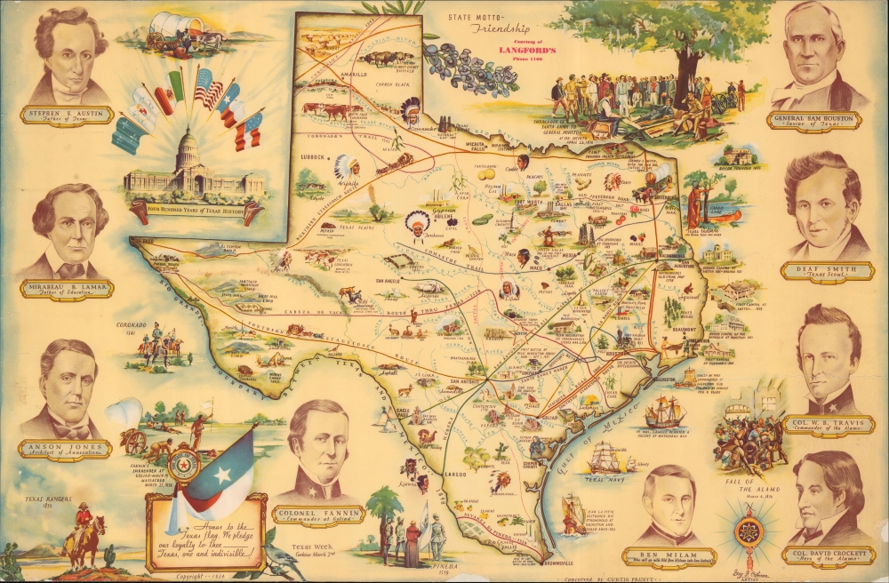
A lively, large-format pictorial historical map of Texas, 'conceived' by Curtis Pruett and drawn by Guy F. Cahoon in 1934, in advance of the centennial of the Texas Revolution and the founding of the Republic of Texas. It depicts many of the central players in the revolution and founding fathers of the republic, including Sam Houston, Stephen Austin, James Fannin, and William Travis.
A Closer Look
Depicting the contemporary (1934) state of Texas, illustrations abound, noting Native American tribes, forts, important historical sites and events, wildlife, agricultural produce, and mineral resources. Historic routes used by the Native Americans, Spanish, and Mexicans, as well as later stagecoach routes, are traced. Additional illustrations appear around the map of the state and in the margins, highlighting the founding fathers of independent Texas and central events of the Texas Revolution. Towards top-left is an illustration of the state capitol building in Austin with the six flags under which Texas has existed (Spanish, French, Mexican, Republic of Texas, Confederate States of America, and United States of America), the inspiration for the name of the popular theme park chain.Publication History and Census
This pictorial map was 'conceived' by Curtis Pruett and drawn by Guy F. Cahoon in 1934, and this example was sponsored by Langford's, perhaps referring to Pierce P. Langford, a prominent businessman with multiple operations based in Wichita Falls. This is the 'Official Centennial Map of Texas' (OCLC 310361940), for the Daughters of the Republic of Texas, which has had the border and title trimmed, presumably for framing. That map is noted among the holdings of eight institutions in the OCLC, is also held by the Texas State Archives Map Collection and the Museum of the Big Bend, and only occasionally appears on the market.
CartographerS
Cahoon, Guy Forsythe (c. 1899 - 1971) was an artist based in Dallas, Texas. He was born in Illinois, but little else is known of his early life and training. By 1912, he began appearing in Dallas city directories as a draughtsman or commercial artist, and continued to do so until the early 1970s. He also appears to have designed some homes. In terms of publications, he was most active in the 1930s, producing illustrated works on local history and culture, as well as a textbook of sorts titled Commercial Art. His cartographic output includes 'The Official Centennial Map of Texas' (1934) and a later 'Historical Map of Texas' (1967), which may be a later reprint of the former, both for the Daughters of the Texas Revolution. More by this mapmaker...
Curtis D. Pruett (fl. c. 1925 - 1967), sometimes as Curtis B. Pruett, was an artist and art shop owner in Dallas, Texas. He appears in Dallas city directories as an artist as early as 1925, and was also occasionally referred to as a 'display architect.' Little is known about his life and work aside from his involvement with 'The Official Centennial Map of Texas' (1934) and a later 'Historical Map of Texas' (1967), which may be a later reprint of the former, both for the Daughters of the Texas Revolution. Learn More...
Average. Backed on archival tissue. One 8-inch tear on right border professionally repaired. Small tears and areas of surface abrasion along edge. Missing content along all margins. Priced accordingly.
OCLC 310361940. Texas State Library and Archives Call. No. 976.4062 G123t.