This item has been sold, but you can get on the Waitlist to be notified if another example becomes available, or purchase a digital scan.
1860 Black Map of the World
TheWorld-black-1860$50.00

Title
The World
c. 1800 (undated) 11 x 16 in (27.94 x 40.64 cm)
c. 1800 (undated) 11 x 16 in (27.94 x 40.64 cm)
Description
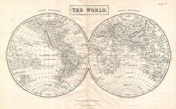
A highly detailed mis-19th century map of the World in Hemispheres Divided into the Western Hemisphere and Eastern Hemisphere, this map shows and labels islands, continents, major cities, oceans, capes, gulfs and mountains. Also shows latitudinal and longitudinal degrees and temperate, frigid, and torrent zones. Engraved by S. Hall and published by Adam and Charles Black.
Cartographer
Charles and Adam Black (fl. 1807 - present) were map and book publishers based in Edinburgh. Charles and his uncle, Adam, both of Edinburgh, Scotland, founded their publishing firm in 1807. They published a series of maps and atlases throughout the 19th century. In addition to an array of atlases, the Black firm is known for their editions of the Encyclopedia Britannica (1817 - 1826) and the first publishing of Sir Walter Scott's novels in 1854. In 1889 the A. & C. Black publishing house moved to London where it remains in operation to this day. More by this mapmaker...
Condition
Good condition.