This item has been sold, but you can get on the Waitlist to be notified if another example becomes available, or purchase a digital scan.
1784 Bocage Map of the Battle of Thermopylae Pass, Ancient Greece
Thermopylae-bocage-1791$112.50

Title
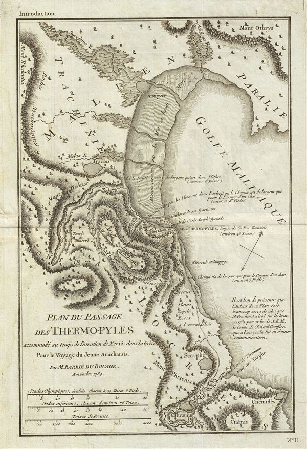
Plan du Passage des Thermo-pyles accommode' au temps de l'invasion de Xerxes dans la Grece Pour le Voyage du Jeune Anacharsis.
1784 (dated) 13.5 x 9 in (34.29 x 22.86 cm)
1784 (dated) 13.5 x 9 in (34.29 x 22.86 cm)
Description
This is a fascinating 1784 map or plan of the Thermopylae Pass in Ancient Greece. Also known as 'The Hot Gateway' due to the numerous sulfur springs. This pass is the site if the famous 480 BC Battle of Thermopylae between Xerxes I of Persia and the 300 Spartans, led by King Leonidas. According to the accounts of the Greek historian Herodotus, the two armies fought for three days by the end of which the 300 Spartans fought to the last man, defending the only road through which the Persian army could pass. essentially a delaying action, the Spartan sacrifice allowed the other Greek city states to prepare their forces, eventually setting the stage for the defeat of Xerxes in the Battles of Plataea and Salamis. This battle was the inspiration for the 2007 Hollywood blockbuster '300.' Prepared by M. Barbie de Bocage in 1784 to illustrate the Travels of Anacharsis.
Anacharsis was a Scythian philosopher who travelled from his homeland on the northern shores of the Black Sea to Athens in the early 6th century BCe. Apparently he made a great impression on the Greeks, who considered him a forthright, outspoken 'barbarian. He is considered a forerunner of the Cynics.
Anacharsis was a Scythian philosopher who travelled from his homeland on the northern shores of the Black Sea to Athens in the early 6th century BCe. Apparently he made a great impression on the Greeks, who considered him a forthright, outspoken 'barbarian. He is considered a forerunner of the Cynics.
Cartographer
Jean Denis Barbie du Bocage (1760 - 1825) and his son Jean-Guillaume Barbie du Bocage (1795 - 1848) were French cartographers and cosmographers active in Paris during late 18th and early 19th centuries. The elder Barbie du Bocage, Jean Denis, was trained as a cartographer and engraver in the workshops of mapmaking legend J. B. B. d'Anville. At some point Jean Denis held the post of Royal Librarian of France and it was through is associations with d'Anville that the d'Anville collection of nearly 9000 maps was acquired by French Ministry of Foreign Affairs. The younger Barbie du Bocage, Jean-Guillaume, acquired a position shortly afterwards at the Ministry of Foreign Affairs and, in time, became its head, with the title of Geographe du Ministere des Affaires Etrangeres. More by this mapmaker...
Source
Barbie du Bocage, J. D., Recueil de Cartes Geographiques Plans, Vues, et Medailles de l'Ancienne Grece, Reelatifs au Voyage du Jeune Anacharsis., (Paris, Chez Sanson et Compagnie), 1791.
Condition
Very good. Original platemark visible. Original fold lines visible. Blank on verso. Dark clean impression.