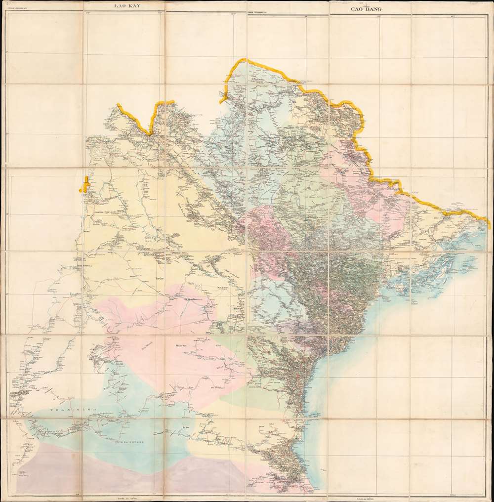
1899 French Bureau Topographique Map of Tonkin, Indochina, North Vietnam
TonkinVietnam-topographique-1899$1,200.00


Title
Tonkin.
1899 (undated) 50.5 x 49.75 in (128.27 x 126.365 cm) 1 : 500000
1899 (undated) 50.5 x 49.75 in (128.27 x 126.365 cm) 1 : 500000
Description
An unusual hand-compiled 1899 dissected map of Tonkin, or North Vietnam, prepared and published by the Bureau Topographique des Troupes de l'Indo-Chine.
We have been unable to trace any other examples of the individual charts used to compile into this large map of North Vietnam. One-of-a-kind.
A Closer Look
Coverage extends from the China border to the Red River and inland as far as Luong Prabang, in modern-day Laos. The inclusion of Laos is significant, as it suggests the map was issued around 1899, when the French Protectorate of Laos was integrated into French Indochina. The map offers an outstanding density of information on a scale of 1:500000, making it one of the more detailed general surveys available at the time. Nonetheless, lacking topographical detail, the map's focus is on villages, roads, and rivers, thus underscoring the provisoire nature of the piece.Publication History and Census
The map is a unique piece compiled from at least four cartes provisoire or 'provisional maps' dissected and assembled c. 1899. We have based the date on the content of the pieces, the printing style, and a vague reference in the 1899 Geographical Journal, volume 22 (page 723). They stylistically match other work printed in Hanoi by the Bureau Topographique des Troupes de l'Indo-Chine. Although the survey work is highly detailed, the printing quality is far cruder than pre-1890 work by the same agency, which was printed in France. The Bureau Topographique acquired a basic lithograph press in that year, and began printing maps for French ground troops operating in the Indochine theater.We have been unable to trace any other examples of the individual charts used to compile into this large map of North Vietnam. One-of-a-kind.
Cartographer
Bureau Topographique des Troupes de l'Indo-chine (fl. c. 1886 - 1900) was founded in 1886 in Hanoi. Its first major project was a 1:2000000 map of the entirety of Indochina, for which they drew on source maps created by the Service Hydrographique de la Marine and those created by an expeditionary corps sent throughout the region. Before establishing its own printing facilities in Indochina in 1890, the Bureau Topographique transferred their work back to Paris to be printed by the Service Géographique de l'Armée. In 1890 the Bureau Topographique also began to increase its cartographic output. The Bureau Topographique sent army officers on triangulation and topographic missions in unexplored areas of Indochina throughout the 1890s, some of which proved fatal for the participants. It is unclear when the Bureau Topographique shut down, but no examples of their work postdate 1900. More by this mapmaker...
Condition
Very good. Dissected and mounted on original linen. Manuscript title on verso.