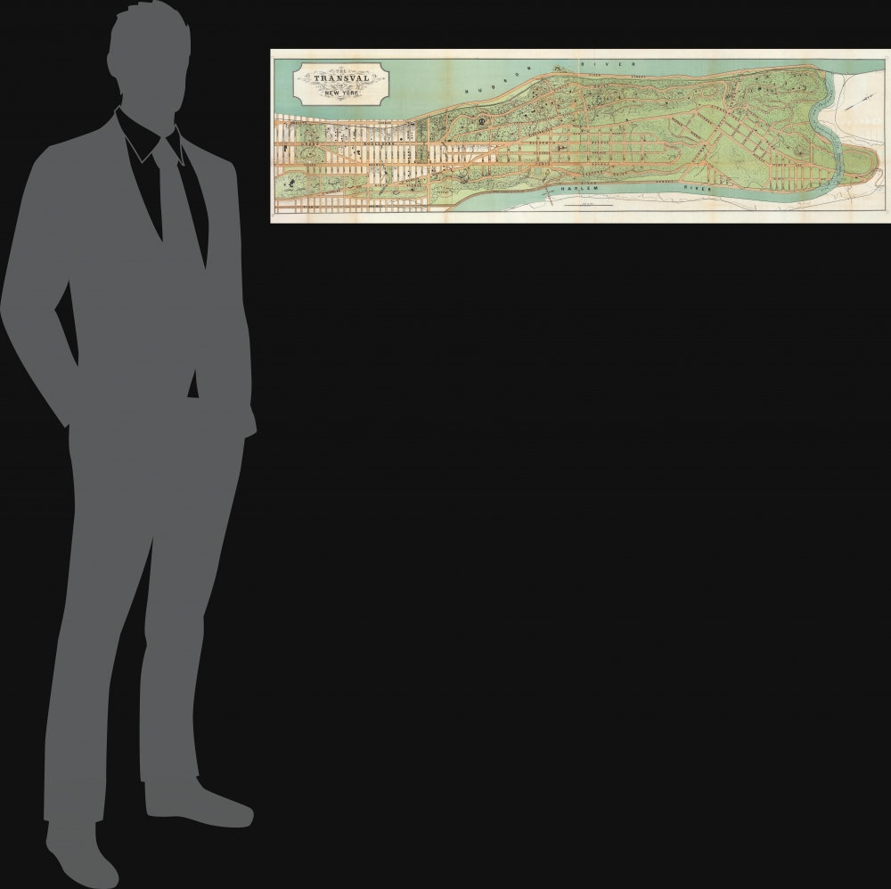
1880 Viele Map of Upper Manhattan (Washington Heights, Fort George, and Inwood)
TransvalNewYork-viele-1880$1,200.00


Title
The Transval of New York.
1880 (undated) 14.5 x 53.75 in (36.83 x 136.525 cm) 1 : 6000
1880 (undated) 14.5 x 53.75 in (36.83 x 136.525 cm) 1 : 6000
Description
This is an 1880 Egbert Ludovicus Viele map of upper Manhattan. The map depicts the city from 130th Street to the Spuyten Duyvil Creek and from the Hudson River to the Harlem River. Numerous streets are illustrated and labeled. The parks and buildings are illustrated but not identified, with the exception of Fort Washington and Trinity Cemetery.
The Development of Washington Heights, Fort George, and Inwood
An notable change occurs in Manhattan at 155th Street. Below, the grid system is in control and dominates the island. Natural obstacles, such as hills, cliffs, etc., were leveled in order to impose the strict grid onto an unruly landscape. Above 155th, the exact opposite occurred, and the streets were developed 'organically'. The grid system was used in this part of Manhattan, but only in the valleys between the ridges and other physical features, but otherwise the roads curve around terrain, giving this part of Manhattan a more natural layout. This program was spearheaded and designed by Andrew Haswell Green, who many consider to be the Father of Greater New York. Tragically, he was murdered in his home in 1903 before he was able to completely cement his vision. Viele's 1880 plan illustrates the city as it was in 1880, but, partially due to Green's untimely death, the grid invaded in the 1930s, taking over more ground from Green's innovative organic plan.Publication History and Census
This map was created by Egbert L. Viele and published in 1880. We note five cataloged examples which are part of the collections at the New York Public Library, the Museum of the City of New York, Columbia University, the University of Wisconsin Milwaukee, and Stanford University. It is extremely rare on the market, appearing only twice in the last ten years.Cartographer
Egbert Ludovicus Vielé (June 17, 1825 - April 22, 1902) was an American civil engineer, cartographer, businessman, and politician active in New York City during the second half of the 19th century. Born in Saratoga County, Vielé attended the United States Military Academy at West Point. Graduating in 1847, he was commissioned as a brevet second lieutenant in the 2nd United States Infantry. He served in the Mexican-American War before resigning form military duty to pursue a career as a Civil Engineer in New York City. When the call came to plan New York City's Central Park in 1856, Vielé was established as Engineer-in-Chief of the project, and it was he who set down the guidelines by which Vaux and Olmstead ultimately planned the park. He held a similar position as engineer of Prospect Park, Brooklyn from 1860. It was most likely during his tenure with the park commissions that Vielé developed his theories connecting compromised natural drainage with sanitation and infectious disease. Vielé's great cartographic masterpiece, the Topographical Map of the City of New-York, euphemistically known as the 'Vielé Map' or 'Waterways Map' evolved out of the notion that epidemic level disease evolved from excess moisture in the soil. He contended that, as New York City expanded northwards, paving over stream beds and leveling out natural drainage channels, the underground waterways would stagnate and lead to plague or worse. Though intended for the purpose of urban planning, the Vielé Map's (as it came to be known) greatest legacy is as a construction tool. To this day, contractors, architects, and engineers consult the Vielé map to determine if unseen subterranean waterways need to be taken into account when preparing building foundations. He was elected as a Democratic representative to the Forty-ninth Congress (March 4, 1885 – March 3, 1887) and ran unsuccessfully for re-election in 1886. He was heavily involved in New York real-estate interests, but also owned shares of mining and railroad companies as far off as Colorado. Vielé died in April of 1902 and was buried in an elaborate Egyptian Revival tomb at West Point. Legend tells that Vielé, paranoid that he would be buried alive, an unfortunate but surprisingly common problem in the 19th century, installed a buzzer inside his coffin that would allow him to ring the school's commanding officer should the need arise. Apparently, it did not. More by this mapmaker...
Condition
Very good. Backed on archival tissue for stability. Closed tear extending two inches from left margin professionally repaired on verso.
References
New York Public Library Map Div. 15-682. Rumsey 3221.003. OCLC 76803025.