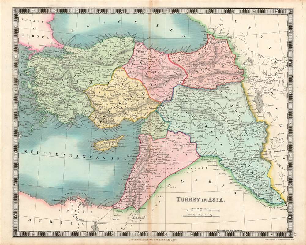
This is a brilliantly colored 1831 Henry Teesdale / John Dower map of the 'Turkey in Asia,' that is, the Asian portion of the Ottoman Empire. This map was published as the Ottoman Empire faced both external and internal threats, and an acute existential crisis from within at the hands of Muhammed Ali Pasha, which the dynasty only survived thanks to a foreign intervention.
A Closer Look
This map illustrates the Ottoman Empire in Asia, which by the time this map was produced was most of what remained of the empire, as the Ottomans had lost much of their territory in southeastern Europe to nationalist independence movements. Declining Ottoman authority, social discontent, and rising nationalist sentiment also caused Istanbul to lose control of Egypt (discussed below) and to retain only a weak grip over much of the Levant. These vulnerabilities would be exploited repeatedly by Britain, France, and Russia, who were only limited by a desire not to see each other gain too strong of a foothold in the Levant.Decline of the Ottoman Empire and the Rise of Muhammed Ali Pasha
Throughout the 19th century, the Ottoman Empire was beset not only by external threats (a string of wars against Russia in particular) but also by internal division. National awakenings in the Balkans at the start of the 19th century had forced Istanbul to relinquish control over Serbia and to fight a losing battle to retain Greece. Meanwhile, and not for the first time in Ottoman history, a dynamic administrator and military commander proved to be a double-edged sword. Muhammed Ali Pasha initially came to power in Egypt after being dispatched by the Ottomans to restore their authority there, which had been overturned by Napoleon's invasion in 1798 and a subsequent civil war. He was successful in pacifying Egypt, but then immediately moved to declare himself ruler of the province and instituted a range of modernizing reforms.
Muhammed Ali was a powerful weapon for the Ottomans, conquering Sudan, reconquering Arabia, and nearly reconquering Greece until he was stymied by a combined British, French, and Russian intervention at Navarino in 1827, which sank his entire navy. However, he was also ambitious and beyond the control of Istanbul (which explains Egypt not being included among Ottoman lands here). In exchange for his military campaigns, Muhammed Ali demanded that the Sultan grant him control of Syria. When that demand was rejected, the same year this map was published, Muhammad Ali launched an invasion of Syria, handily defeating Ottoman forces before moving further into Anatolia. The Ottomans were only saved through the intervention of Russia, which blocked the route to Istanbul. Thereafter, Britain and France brokered an agreement that capped Russia's influence in Turkey (their primary concern) while mollifying Muhammed Ali by granting him Syria.
Less than a decade later, the Egyptians and Ottomans waged war again, with Muhammed Ali again winning handily and again being prevented from capturing Istanbul by an intervention of major European powers. However, he was effectively granted de jure autonomy over Egypt, establishing an independent dynasty, in exchange for leaving Ottoman Syria. Unfortunately for Muhammed Ali, his successors were not nearly as capable or wily as he, and the dynasty's power waned vis-à-vis European powers, with Egypt falling under British occupation and then a protectorate in the late 19th - early 20th century.Publication History and Census
This map was engraved by John Dower for the 1831 edition of A New General Atlas of the World, published by Henry Teesdale. This appears to be an especially rare presentation of this map, as examples in the David Rumsey Historical Map Collection and other major digital repositories from other editions of the map do not show such vivid and full color. The 1831 edition of this map is only independently cataloged in the holdings of four institutions, while the entire atlas is held by roughly a dozen institutions, though as stated above the present map may be distinct from those examples in coloration.
CartographerS
John James Dower (June 1, 1825 - 1901) was a well-respected mapmaker, print seller, and publisher based in London, England. Dower is the heir to the more prominent London engraver and mapmaker John Crane Dower (1791 - 1847). Dower worked with many prominent middle to late 19th century London map publishers including Weller, Cassell, Bacon, Petermann, and others. He was elected to the Royal Geographical Society in 1854. Dower also published on maps his own account including one atlas and various school geographies. In addition to his cartographic work, Dower is well known as an engraver of military scenes. More by this mapmaker...
Henry Teesdale (December 1776 - January 1856) was a British map publisher active in the first half of the 19th century. Teesdale was born in London. He was elected to the Royal Geographical Society in 1830. Teesdale initially partnered with John Hordan and William Colling Hobson as Henry Teesdale and Company, but this partnership was dissolved in 1832. Afterwards Teesdale continued to publish maps and atlases on his own account. He worked with several major British map engravers of the period including John Crane Dower, Christopher Greenwood, and Josiah Henshall, among others. His most prominent work is a large map of the world engraved by Dower. He must have enjoyed considerable commercial success because in 1845 he is registered as a partner in the Royal Bank of Scotland. Teesdale died in January of 1856 and was buried in All Souls, Kensal Green. Learn More...
Source
Dower, John, A New General Atlas of the World, (London: Teesdale) 1831.
Good. Discoloration along the central fold line.
OCLC 43214443.