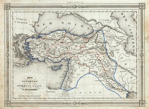
1852 Lavasseur Map of Turkey in Asia
TurkeyAsia-levasseur-1852$150.00

Title
Asie Ottomane ou Turquie d'Asie.
1852 (undated) 10 x 13 in (25.4 x 33.02 cm)
1852 (undated) 10 x 13 in (25.4 x 33.02 cm)
Description
An uncommon and extremely attractive 1852 map of Turkey in Asia by Victor Levasseur. The map covers the Asian territories claimed by the Turkish Ottoman empire c. 1850 from the Black Sea to Arabia, including Cyprus. Centered on the Holy land (Palestine / Israel), the map covers the modern day countries of Turkey, Cyprus, Iraq, Israel, Palestine, Jordan, Lebanon, and Syria. Throughout, the map identifies various cities, towns, rivers and assortment of additional topographical details. The map to the last days of the Ottoman empire, whose influence, though rapidly declining, still dominated much of the Middle east. The map features a beautiful frame style border. Prepared by Victor Levasseur for publication as plate no. 21 in Maison Basset's 1852 edition of Atlas Illustre Destine a l'enseignement de la Geographie elementaire.
CartographerS
Victor Levasseur (1800 - 1870), an important French engineer, cartographer, and engraver of the mid 19th century, held a number of important cartographically related political and educations posts in France. He is most famous for his Atlas National Illustré des 86 Départements et des Possessions de La France, a large decorative atlas of France, including his Planisphere and five important continental maps. Levasseur's maps are distinctive for their wide decorative margins containing elaborate depictions of the scenery, peoples, and trade goods of the areas he mapped. Levasseur maps are also known to offer a wealth of statistical data. Until recently, very few Levasseur Atlases migrated out of France where they were mostly used in public libraries and town halls. His work represents some of the last great decorative atlases of the 19th century. More by this mapmaker...
Jean Denis Barbie du Bocage (1760 - 1825) and his son Jean-Guillaume Barbie du Bocage (1795 - 1848) were French cartographers and cosmographers active in Paris during late 18th and early 19th centuries. The elder Barbie du Bocage, Jean Denis, was trained as a cartographer and engraver in the workshops of mapmaking legend J. B. B. d'Anville. At some point Jean Denis held the post of Royal Librarian of France and it was through is associations with d'Anville that the d'Anville collection of nearly 9000 maps was acquired by French Ministry of Foreign Affairs. The younger Barbie du Bocage, Jean-Guillaume, acquired a position shortly afterwards at the Ministry of Foreign Affairs and, in time, became its head, with the title of Geographe du Ministere des Affaires Etrangeres. Learn More...
Source
Barbie du Bocage, J. D., Atlas Illustre Destine a l'Enseignement de la Geographie Elementaire, (Paris: Maison Basset) 1852.
Condition
Very good. Blank on verso. Minor foxing throughout.