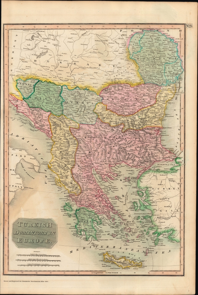
A lovely example of John Thomson's 1815 map of 'Turkey in Europe,' that is, the European portion of the Ottoman Empire. Though Ottoman rule of Southeastern Europe was long-established, by this time cracks were appearing that would spell the rapid retreat of Ottoman power and the rise of new kingdoms and nation-states.
A Closer Look
This hand-colored steel plate engraving includes Greece, Serbia, Bosnia, Croatia, Dalmatia, Macedonia, Romania, Bulgaria, Wallachia, and Moldavia. Towns and cities, roads, waterways, mountains, and other features are noted throughout. Along the coasts, ports, capes, bays, gulfs, and islands are indicated. A dashed line at bottom-right traces a boundary between Europe and Asia through the Aegean and Sea of Marmara.
'Turkey in Europe' and variations on that term were standard among mapmakers of the time, but in the 18th century the Ottoman Empire's position in Europe was increasingly imperiled by Austria and especially Russia, increasingly assertive and powerful. Internal struggles also weakened the Ottoman grip on southeastern Europe, from nascent nationalist movements and debates on religious toleration to infighting over the tactics and status of the janissary corps. A drawn-out revolution in Serbia starting in 1804 and a Greek uprising in 1821 were the catalysts for the empire's partial collapse in Europe. The 'Eastern Question' dealing with the fate of the Ottoman European territories, and specifically, for Britain, preventing their rapid conquest by Russia, was a major diplomatic question of the 19th century. Publication History and Census
This map was drawn and engraved in 1815 for the first edition of John Thomson's New General Atlas, published in 1817. Many of the maps in Thomson's atlas are double-page sheets, but the present map originally appeared on a sheet opposite a map of Attica, that is, Athens and environs (also sold by us) (see Rumsey 1007.026 for reference). It was most likely engraved by E. Mitchell, whose name appears below the Attica map.
Cartographer
John Thomson (1777 - c. 1841) was a Scottish cartographer, publisher, and bookbinder active in Edinburgh during the early part of the 19th century. Thomson apprenticed under Edinburgh bookbinder Robert Alison. After his apprenticeship he briefly went into business with Abraham Thomson. Later the two parted ways, John Thomson segueing into maps and Abraham Thomson taking over the bookbinding portion of the business. Thomson is generally one of the leading publishers in the Edinburgh school of cartography which flourished from roughly 1800 to 1830. Thomson and his contemporaries (Pinkerton and Cary) redefined European cartography by abandoning typical 18th century decorative elements such as elaborate title cartouches and fantastic beasts in favor of detail and accuracy. Thomson's principle works include Thomson's New General Atlas, published from 1814 to 1821, the New Classical and Historical Atlas of 1829, and his 1830 Atlas of Scotland. The Atlas of Scotland, a work of groundbreaking detail and dedication would eventually bankrupt the Thomson firm in 1830, at which time their plates were sequestered by the court. The firm partially recovered in the subsequent year allowing Thomson to reclaim his printing plates in 1831, but filed again for bankruptcy in 1835, at which time most of his printing plates were sold to A. K. Johnston and Company. There is some suggestion that he continued to work as a bookbinder until 1841. Today, Thomson maps are becoming increasingly rare as they are highly admired for their impressive size, vivid hand coloration, and superb detail. More by this mapmaker...
Source
Thomson, J., A New General Atlas, (Edinburgh) 1817.
Thomson's New General Atlas was first published in 1817 and continued to be published until about 1821. This is the first of Thomson's major cartographic works and the atlas for which is most celebrated. The New General Atlas follows in the Edinburgh School, which eschews excessive decoration in favor of a more minimalistic fact-based cartographic vision, as established by John Pinkerton, Laurie and Whittle, John Cary, and others in the previous decades. The maps are notable for their massive scale, heavy stock, elegant color work, and easy-to-read typefaces. Although the atlas stopped being published after 1821, Thomson continued to offer 'supplementary' maps that could be tipped into the atlas as late as 1830, when he declared bankruptcy. The maps in the Thomson Atlas were engraved by Thomas Clerk, William Dassauville, Nathaniel Rogers Hewitt, James Kirkwood, Robert Kirkwood, John Menzies, George Menzies, Edward Mitchell, John Moffatt, Samuel John Neele, Robert Scott, and James Wyld.
Very good condition. Narrow left margin. Slight offsetting.
Rumsey 1007.026. Phillips, 731. Newberry Library: Ayer +135 T4 1817.