This copy is copyright protected.
Copyright © 2024 Geographicus Rare Antique Maps
1789 Djurberg Map of Polynesia with indigenous name for Australia (Ulimaroa)
UlimaroaAustralia-djurberg-1789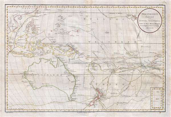

On page 436 of Hawkesworth’s account of Cook’s first voyage, Ulimaroa is mentioned as the biggest island in the world. I should give a reason for this name. This land is called New Holland in a lot of maps, but for what reason I do not know; there is no similarity between Holland in Europe and this land, neither in size nor in the area’s character. You find in the account of the famous English sailor Cook’s journeys that when he was on the northern coast of New Zealand, he asked the inhabitants there if they knew any other country, to which they replied that to the north-west of their home, a quite large land was located, which they called Ulimaroa. I have decided to maintain this name as given to this land by its neighbors; besides it is better than New Holland.On a secondary level, the map is notable for its detailed accounting of the various exploratory missions to the South Pacific in the 17th and 18th centuries. These include the routes of James Cook , Abel Tasman, Philip Carteret, Alvaro de Mendaña de Neira, Pedro Fernandes de Queirós, Charles Clerke, and Samuel Wallis. Its coverage extends from Taiwan (Formosa) and Hawaii, south as far as New Zealand.
Daniel Djurberg (June 3, 1744 – October 2, 1834) was a Swedish geographer and cartographer active in the late 18th and early 19th centuries. Djurberg as the grandson of the well-known theologian of the same name. He was born in Gävle, Sweden, and studied at Uppsala University. He held academic positions at several schools, including at the Katarina Skola (1776) and Klara Skola (1782). As a cartographer one of Djurberg's idiosyncrasies was using alternative indigenous nomenclature: Vingandacoa for North America and Ulimaroa for Australia, among others. More by this mapmaker...
Franz Anton Schrämbl (Schraembl; 1751 - December 13, 1803) was a Vienna-based cartographer working in the later part of the 18th century. Schrämbl was born in Vienna. He became director of the normal school in Troppau but soon quit to set up a bookshop in Vienna. In 1787, with fellow Austrian Franz Johann Joseph von Reilly (1766 - 1820), he founded a publishing firm. He began his great work, the Allgemeiner Grosser Atlas, in the same year. This ambitious large format atlas was to be based upon only the most up-to-date cartographic information available, among them cartographers J. B. B. D'Anville (1697 - 1782) and James Rennel (1742 - 1830), and explorers such as James Cook (1728 - 1779), Charles Roberts (1739 - 1825), and others. The atlas was published in 1800 and became the first Austrian commercial world atlas. The work experienced minimal circulation, possibly due to its high cost. The low sales nearly drove Schrämbl into insolvency, but he recovered through diversification into literature and art books. When Franz Anton died in 1803, his widow Johanna and her brother, the engraver Karl Robert Schindelmayer (1769 - 1839), assumed control of the firm. In 1825, his son, Eduard Schrämbl, took over. Learn More...
Copyright © 2024 Geographicus Rare Antique Maps | Geographicus Rare Antique Maps
This copy is copyright protected.
Copyright © 2024 Geographicus Rare Antique Maps