
This item below is out of stock, but another example (left) is available. To view the available item, click "Details."
Details
1862 Mitchell Map of the United States w/Confederate Arizona
1862 (dated) $350.00
1865 Mitchell Map of the United States / 1st Map w/ Wyoming
UnitedStates-mitchell-1865$225.00

Title
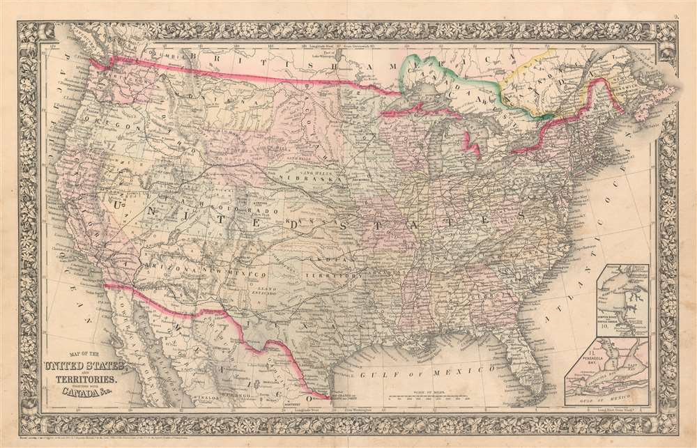
Map of the United States and Territories. Together with Canada etc.
1860 (dated) 14 x 22 in (35.56 x 55.88 cm) 1 : 10000000
1860 (dated) 14 x 22 in (35.56 x 55.88 cm) 1 : 10000000
Description
This is the first of two states of Samuel Augustus Mitchell Jr.'s 1865 map of the United States. Depicting the entire continental United States and including parts of Canada and Mexico, all the states and territories are identified, and myriad cities and towns are labeled from coast to coast. Rivers and lakes are also labeled. Two inset maps situated in the lower right corner illustrate Hampton Roads and Pensacola Bay.
Wyoming - 'Attached to Dacotah'
This map is important due to its inclusion of a territory that roughly approximates the Wyoming Territory. A bill was introduced in Congress in January 1865 to create a provisional Wyoming Territory (see Geographicus: unitedstateswyoming-mitchell-1865), but that effort failed. Here Mitchell includes for the first time this proposed territory, although it is unnamed and referred to simply as 'Attached to Dacotah'. This territory's eastern border aligns with the 104th Parallel, which was the traditional border of the Dacotah region. On the subsequent state of Mitchell's 1865 map, these borders would be changed.Publication History
This map was created and published by Samuel Augustus Jr. in the 1865 edition of his New General Atlas.Cartographer
Samuel Augustus Mitchell (March 20, 1792 - December 20, 1868) began his map publishing career in the early 1830s. Mitchell was born in Bristol, Connecticut. He relocated to Philadelphia in 1821. Having worked as a school teacher and a geographical writer, Mitchell was frustrated with the low quality and inaccuracy of school texts of the period. His first maps were an attempt to rectify this problem. In the next 20 years Mitchell would become the most prominent American map publisher of the mid-19th century. Mitchell worked with prominent engravers J. H. Young, H. S. Tanner, and H. N. Burroughs before attaining the full copyright on his maps in 1847. In 1849 Mitchell either partnered with or sold his plates to Thomas, Cowperthwait and Company who continued to publish the Mitchell's Universal Atlas. By about 1856 most of the Mitchell plates and copyrights were acquired by Charles Desilver who continued to publish the maps, many with modified borders and color schemes, until Mitchell's son, Samuel Augustus Mitchell Junior, entered the picture. In 1859, S.A. Mitchell Jr. purchased most of the plates back from Desilver and introduced his own floral motif border. From 1860 on, he published his own editions of the New General Atlas. The younger Mitchell became as prominent as his father, publishing maps and atlases until 1887, when most of the copyrights were again sold and the Mitchell firm closed its doors for the final time. More by this mapmaker...
Source
Mitchell, S. A., Mitchell's New General Atlas Containing Maps of the Various Countries of the World, Plans of Cities, Etc., embraced in Forty-Seven Quarto Maps, Forming a series of Seventy-Six Maps and Plans, together with Valuable Statistical Tables (1865 edition).
Mitchell's New General Atlas was published by Samuel Augustus Mitchell, Jr., the son of the prolific cartographer Samuel Augustus Mitchell. Many of the plates are derived from the his father's Mitchell's Universal Atlas, but not directly. The Mitchell's Universal Atlas was initially sold to Thomas, Cowperthwait, and Company in 1849, and again to Charles Deliver in 1856. It was Deliver who introduced the new vibrant color scheme, abandoning the older Mitchell's Universal Atlas green borders and themes for bright reds, blues, and yellows. Samuel Augustus Mitchell, Jr. acquired the Deliver plates in 1859. He added his own floral motif border, but doubled down on the vibrant color scheme, thus introducing to the American public the most vividly colored American atlas of the 19th century. In 1860, he published the first edition of his New General Atlas and, despite a slump in sales during the American Civil War, attained a level of success to rival his father. Mitchell would continue to publish the New General Atlas until 1887, when the firm formally closed.
Condition
Very good. Even overall toning. Light wear along original centerfold. Blank on verso.