1817 Mollo Map of the United States
UnitedStates-mollo-1817$500.00

Title
Vereinigte Staaten in Nord America nach den besten Hülfsmittel verlast, Wein bey T. Mollo.
1817 (undated) 13 x 18 in (33.02 x 45.72 cm) 1 : 10000000
1817 (undated) 13 x 18 in (33.02 x 45.72 cm) 1 : 10000000
Description
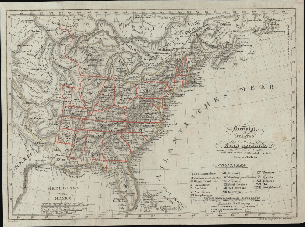
A striking c. 1817 map of the United States by Tranquillo Mollo depicting the ephemeral period between the Louisiana Purchase and organized territorial expansion into the Transmississippi.
A Closer Look
The map covers from roughly Galveston Bay to the Grand Banks, and from Hudson's Bay to southernmost Florida. Individual state borders, as they existed at the time, are highlighted in red, while international borders are defined in yellow. A table in the lower right lists 18 provinces including, curiously, 'Neu Orleans'. A note below this identifies territories not yet ratified as states: Luisana, Missisippi, Yllinois, Indiana, and Mischigan. The map exhibits the fine engraving and high quality printing for which Mollo would later become known as head of Artaria.Early Ephemeral Louisiana Purchase Military Districts
This map exhibits a very ephemeral period in the history of the Transmississippi in the vicinity of Missouri, Arkansas, and Louisiana. Following March 10, 1804, known as 'Three Flags Day,' when the United States physically took possession of Louisiana from France, both Orleans Territory and the District of Louisiana were created in what is modern day Louisiana - both are identified on this map. The lands north of the 33rd parallel were divided into five military districts loosely based upon earlier Spanish land districts: Cape Girardeau, Ste. Genevieve, St. Charles, and St. Louis. Of these counties, Cape Girardeau containing New Madrid was the largest, and from it, the District of Arkansas was spit off in 1806, for judicial reasons. Later, in 1815, the Lawrence County, as seen here, was split off. Howard County (named after deceased territorial governor Benjamin Howard) was divorced from the St. Louis District in 1816.Publication History and Census
This map was compiled in Vienna by Tranquilo Mollo, with exceptional engraving by Lorenz Rieder. There are various editions of this map with various dates. The present example bears a secondary imprint for the Lehrbuch der Geographie (Textbook of Geography), although we have been unable to trace the specific work from which it was extracted. Some references date this map as early as 1807, while other place it as late as 1820. Based on the land districts, this map must date to about 1817. We see examples in three institutions and the map appears on the market from time to time.Cartographer
Tranquillo Maria Laurentio Mollo (August 10, 1767 - March 29, 1837) was a Vienna-based Swiss/Italian graphic designer, printer, art and music dealer, and publisher active in the late 18th and early 20th centuries. From about 1792 Mollo worked with the Vienna firm Artaria and Company. In 1798 he separated from Artaria to found, along with partner Franz Bernardini, his own music, art, and map publishing company, T. Mollo and Co. The partnership collapsed after one year and Mollo took a new partner, Domenico Artaria, a scion of the Artaria family. In 1802 Mollo and Domenico acquired Artaria and Company from Carlo Artaria. Domenico and Mollo parted ways in 1804, after which Mollo published independently. Under his own imprint, he became one of Austria's most important globe and map publishers. He collaborated extensively with English and French publishers to bring French material to his work. Among his more significant collaborators was the Vienna publisher Joseph Dirwaldt. In 1832 Mollo passed the company to his sons, Eduard (1799 - 1842) and Florian Mollo (1803 - 1869). The Mollo brothers ran the business until 1839, three years after Tranquillo Mollo's death, before dividing the concern into separate businesses. More by this mapmaker...
Condition
Very good. Some edge reinforcement.
References
OCLC 38449841.