Digital Image: 1836 Woodbridge Wall Map of the United States w/ Republic of Texas
UnitedStates-phelpssquire-1836_d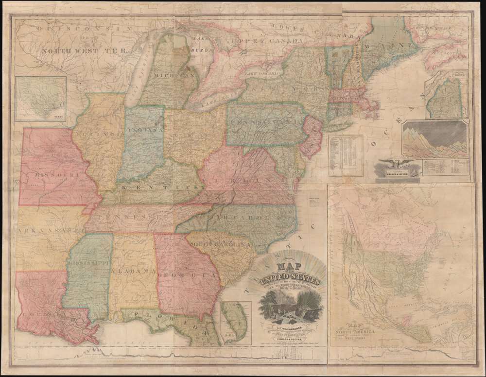

Title
Map of the United States with the Recent Counties, Cities, Villages and Internal Improvements in the Western States.
1836 (dated) 46.25 x 53.25 in (117.475 x 135.255 cm) 1 : 1900800
1836 (dated) 46.25 x 53.25 in (117.475 x 135.255 cm) 1 : 1900800
Description
FOR THE ORIGINAL ANTIQUE MAP, WITH HISTORICAL ANALYSIS, CLICK HERE.
Digital Map Information
Geographicus maintains an archive of high-resolution rare map scans. We scan our maps at 300 DPI or higher, with newer images being 600 DPI, (either TIFF or JPEG, depending on when the scan was done) which is most cases in suitable for enlargement and printing.
Delivery
Once you purchase our digital scan service, you will receive a download link via email - usually within seconds. Digital orders are delivered as ZIP files, an industry standard file compression protocol that any computer should be able to unpack. Some of our files are very large, and can take some time to download. Most files are saved into your computer's 'Downloads' folder. All delivery is electronic. No physical product is shipped.
Credit and Scope of Use
You can use your digial image any way you want! Our digital images are unrestricted by copyright and can be used, modified, and published freely. The textual description that accompanies the original antique map is not included in the sale of digital images and remains protected by copyright. That said, we put significant care and effort into scanning and editing these maps, and we’d appreciate a credit when possible. Should you wish to credit us, please use the following credit line:
Courtesy of Geographicus Rare Antique Maps (https://www.geographicus.com).
How Large Can I Print?
In general, at 300 DPI, you should at least be able to double the size of the actual image, more so with our 600 DPI images. So, if the original was 10 x 12 inches, you can print at 20 x 24 inches, without quality loss. If your display requirements can accommodate some loss in image quality, you can make it even larger. That being said, no quality of scan will allow you to blow up at 10 x 12 inch map to wall size without significant quality loss. For more information, it is best consult a printer or reprographics specialist.
Refunds
If the high resolution image you ordered is unavailable, we will fully refund your purchase. Otherwise, digital images scans are a service, not a tangible product, and cannot be returned or refunded once the download link is used.
Cartographer S
Humphrey Phelps (1799 - 1875) was an American map, broadside, and book publisher based in New York City. Phelps was born in 1799 in Hebron, Connecticut. Phelps' earliest work seems to be a plan of New York City for his Stranger's Guide, dating to about 1830. Between 183- and 1837 he published with Bela Scovil Squire (1786 - 1861) under the imprint of Phelps and Squire. The New York map publishing circle seems to have been quite close and Phelps commonly partnered with various other New York publishers and printers including Edward H. Ensign (1818 - 1871), Horace Thayer, Erastus Clark Bridgman (1817 - 1870), Thomas C. Fanning (1805 - 1873), Hooker, Peabody, Charles Magnus, Gaylord Watson, and George Walker, among others. The natural consequence of his rampant partnering is a vast and varied corpus of work including many scarce items with low print runs. Phelps is best known for his emigrant and tourist guides. More by this mapmaker...
Bela Scovil Squire (June 10, 1810 - August 14, 1882) was a New York jeweler and map publisher active in the early to mid-19th century. Squire was one of some 21 children born farmer to Bela S. Squire Sr. in Pleasant valley, Connecticut. Bella first appears in the map world as the first partner of Humphrey Phelps (1799 - 1875), publishing several maps between 1835 and 1836. After 1837 he became involved with his brother Horatio Squire's jewelry business at 182 Bowery. Learn More...
Peter Charles Varlé (also known as Charles Peter Varlé (c. 1770 - 1835) was a French draughtsman, cartographer, and engineer active in the United States. He was born in toulouse in southern France and left France for Hispaniola (Santo Domingo) at the beginning of the French Revolution. He lived on Hispaniola and worked as an engineer until 1794, when he was forced to flee by the uprising of 1794. He moved to the United States and published a renowned plan of Philadelphia in 1796, along with a second edition in 1802. Varlé lived in Maine in 1795, and later in Massachusetts. He again lived in Philadelphia from 1797-98, and then moved to Baltimore, where he spent the rest of his days, except for time spent in Philadelphia in 1802. Learn More...
References
cf. Rumsey 5463.000 (1845), 5468.000 (1832), 5471.000 (1817).