1841 Phelps and Ensign Wall Map of the United States
UnitedStatesTravellers-phelpsensign-1841$4,000.00


Title
Phelps and Ensign's Travellers' Guide, and Map of the United States, containing the Roads, Distances, Steam Boat and Canal Routes etc.
1841 (dated) 29 x 40.75 in (73.66 x 103.505 cm) 1 : 4750000
1841 (dated) 29 x 40.75 in (73.66 x 103.505 cm) 1 : 4750000
Description
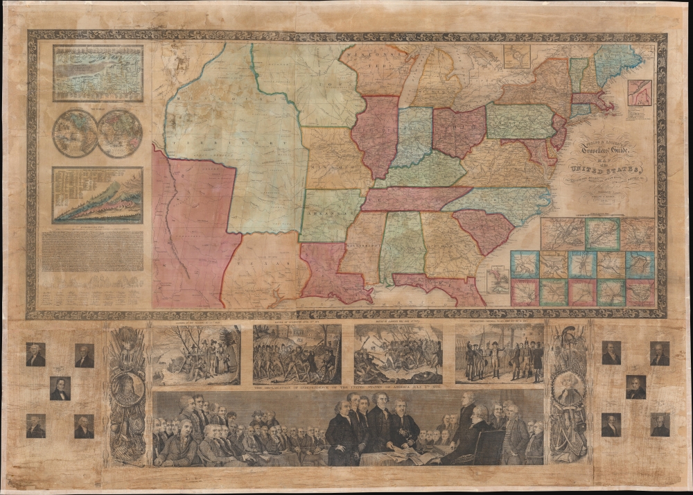
This is the spectacular 1841 edition of Phelps and Ensign's pictorial wall map of the United States and the Republic of Texas. The Republic of Texas appears in one of its smaller configurations, with the printed border reflecting not the vast tracts claimed by the Republic, but rather those lands it effectively controlled - with a border at the Nueces River.
A Closer Look
A large Missouri Territory dominates the western United States, along with a sizeable Iowa Territory. Roads, railroads, cities, and towns appear throughout the country, providing an overview of the ever-expanding transportation network.Pictorial Elements
A small mountains and rivers chart on the Bulla / Darton model appears in the upper left. A large panorama of the Signing of the Declaration of Independence as well as various scenes from American history are situated below the map. To either side are illustrations of Metacom (the Pokunoket Sachem called 'King Philip') and James Polk, who had just been elected 11th president of the United States. Portraits of other former presidents fan out on either side of the panorama.Republic of Texas
The Republic of Texas was a short-lived nation established in March 1836 when it seceded from Mexico. Following the independence of Mexico from Spain, the American Stephen Fuller Austin led a group of 300 Empresarios to settle Texas, near Austin, where they received a grant from the Mexican government. As more Americans moved to Texas, resentment and strife began to build between the American settlers and Mexican authorities. This and other factors ultimately led to the Texan Revolution in 1835 and the declaration of Texan independence in 1836. Texas remained an independent republic until it joined the United States ten years later in 1846.Texas Borders
The borders of the Republic of Texas were in dispute from the earliest days of the Texan Revolution. The Republic-claimed borders followed the Treaties of Velasco between the newly created Texas Republic and Mexican leader, Antonio López de Santa Anna. These treaties adhered to the 1819 Adams-Onís Treaty between the United States and Spain, which established the Sabine River as the eastern boundary of Spanish Texas and the western boundary of the Missouri Territory. The Republic's southern and western boundary with Mexico was more nuanced. Texas claimed the Rio Grande del Norte as its western and southernmost border, while Mexico argued for a boundary much further east at the Nueces River. When Texas was annexed into the United States, the expansionist Polk regime followed the Republic claimed boundary, thus absorbing Mexican-claimed territory as far west as Santa Fe. This escalated already existing tensions between the United States, the former Republic of Texas, and Mexico, ultimately triggering the Mexican-American War (1846 - 1848).Publication History and Census
Phelps and Ensign first issued a map of this title in 1839. That map terminated at the Mississippi. The present example, presaging the Mexican American War and Texas Annexation, is dramatically expanded to include the Rocky Mountains. Various editions were issued in 1840, 1841, and 1845, when Thayer's imprint replaced that of Phelps. Additional publications with major revisions continued until about 1859. The entire series, one of the most decorative in the history of early American map publishing, follows the course of the Westward Expansion and the Mexican American War, and as such, is of the utmost interest to collectors and historians. While maps from this series do come to market from time to time, the individual states, especially the Republic of Texas and Mexican-American War editions, are exceedingly uncommon and poorly represented even in institutional collections.CartographerS
Humphrey Phelps (1799 - 1875) was an American map, broadside, and book publisher based in New York City. Phelps was born in 1799 in Hebron, Connecticut. Phelps' earliest work seems to be a plan of New York City for his Stranger's Guide, dating to about 1830. Between 183- and 1837 he published with Bela Scovil Squire (1786 - 1861) under the imprint of Phelps and Squire. The New York map publishing circle seems to have been quite close and Phelps commonly partnered with various other New York publishers and printers including Edward H. Ensign (1818 - 1871), Horace Thayer, Erastus Clark Bridgman (1817 - 1870), Thomas C. Fanning (1805 - 1873), Hooker, Peabody, Charles Magnus, Gaylord Watson, and George Walker, among others. The natural consequence of his rampant partnering is a vast and varied corpus of work including many scarce items with low print runs. Phelps is best known for his emigrant and tourist guides. More by this mapmaker...
Edward Hooker Ensign (August 18, 1818 - July 10, 1871) was an American map and print publisher based in New York during the middle part of the 19th century. Edward was born in West Hartland, Connecticut. Little is known of Ensign's training but he may have inherited his business from his father, Timothy Ensign (1795 - 1859), who was a map publisher active in New York. Ensign seems to have had a flair for partnerships and variously published with Humphrey Phelps (1799 - 1875), Horace Thayer, Thomas C. Fanning (1805 - 1873) and Erastus C. Bridgman (1817 - 1870), among others. His various imprints include 'Phelps and Ensign' (1841-1844), 'T. and E. H. Ensign' (1844-1848), 'Ensign and Thayer' (1849), 'Ensign, Thayer, and Company' (1850-1851), 'Horace Thayer and Company' (1852), and 'Ensign, Bridgman and Fanning' (1854-1863). It appears that father and son worked together for some time as well, publishing as either 'T. and E. H. Ensign' or 'Ensigns'. At least some of these companies maintained offices in both Buffalo and New York City. Learn More...
Condition
Good. Full professional restoration. Mounted on linen.
References
Boston Public Library, Leventhal Center, G3700 1840 .P5. New York Public Library, Map Div. 01-5146. OCLC 47017064.