Digital Image: 1944 Larmat Map of the Marne River Valley Champagne Vineyards in France
ValleeMarne-larmat-1944_d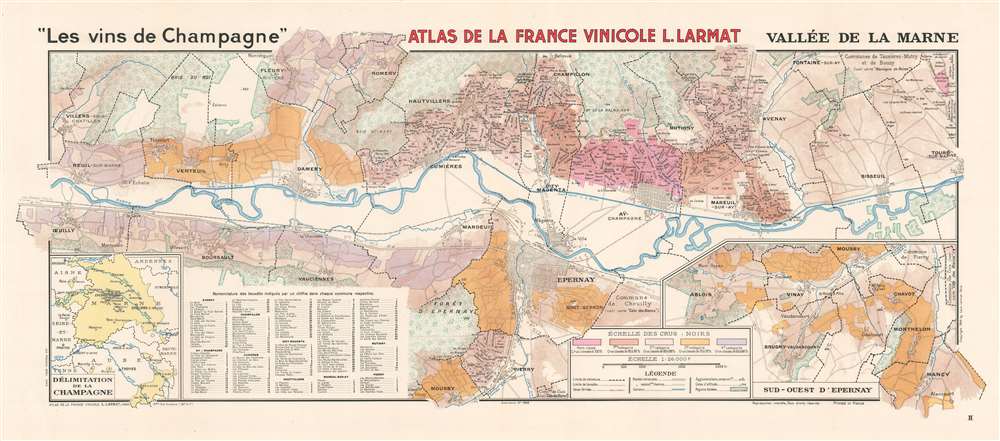

Title
'Les vins de Champagne' Vallée de la Marne.
1944 (dated) 16.5 x 39 in (41.91 x 99.06 cm) 1 : 26000
1944 (dated) 16.5 x 39 in (41.91 x 99.06 cm) 1 : 26000
Description
FOR THE ORIGINAL ANTIQUE MAP, WITH HISTORICAL ANALYSIS, CLICK HERE.
Digital Map Information
Geographicus maintains an archive of high-resolution rare map scans. We scan our maps at 300 DPI or higher, with newer images being 600 DPI, (either TIFF or JPEG, depending on when the scan was done) which is most cases in suitable for enlargement and printing.
Delivery
Once you purchase our digital scan service, you will receive a download link via email - usually within seconds. Digital orders are delivered as ZIP files, an industry standard file compression protocol that any computer should be able to unpack. Some of our files are very large, and can take some time to download. Most files are saved into your computer's 'Downloads' folder. All delivery is electronic. No physical product is shipped.
Credit and Scope of Use
You can use your digial image any way you want! Our digital images are unrestricted by copyright and can be used, modified, and published freely. The textual description that accompanies the original antique map is not included in the sale of digital images and remains protected by copyright. That said, we put significant care and effort into scanning and editing these maps, and we’d appreciate a credit when possible. Should you wish to credit us, please use the following credit line:
Courtesy of Geographicus Rare Antique Maps (https://www.geographicus.com).
How Large Can I Print?
In general, at 300 DPI, you should at least be able to double the size of the actual image, more so with our 600 DPI images. So, if the original was 10 x 12 inches, you can print at 20 x 24 inches, without quality loss. If your display requirements can accommodate some loss in image quality, you can make it even larger. That being said, no quality of scan will allow you to blow up at 10 x 12 inch map to wall size without significant quality loss. For more information, it is best consult a printer or reprographics specialist.
Refunds
If the high resolution image you ordered is unavailable, we will fully refund your purchase. Otherwise, digital images scans are a service, not a tangible product, and cannot be returned or refunded once the download link is used.
Cartographer
Louis Larmat (19xx - xxxx) was a French publisher and cartographer active during the mid-20th century. Larmat published the world's first national wine atlas, his Atlas de la France Vinicole between 1941 and 1947. Divided into six volumes, each volume focused on a specific wine producing region. Volume one detailed wines from Bordeaux and subsequent volumes focused on Bourgogne, les côtes du Rhône, Champagne, les coteaux de la Loire, and the eaux-de-vie de France and cognac. Subsequent editions were published in 1949 and 1953, many of which were updated. It also appears that Larmat intended to produce a series of road maps meant for self-guided wine tours, the 'route des grand crus.' Only one of these is known to exist and focuses on the Bordeaux region. This map was not simply taken from the atlas focusing on Bordeaux. It was a new creation and includes the main roads and vignettes of several of the chateaux. Very little is known about Larmat's life and career apart from the Atlas de la France Vinicole. The Bibliothèque nationale de France notes that he was a publisher in Paris (éditeur Parisien) and provides two Parisian addresses. His earliest accredited publication dates to 1924 and was published in Nice, which suggests the Larmat may have begun his career there. He also published three separate maps later in his career: the general 'Carte de la France Vinicole' by Marcel Azema in 1945, the 'Carte du Vignoble Alsacien' by Robert Louis in 1949, and 'L'Algérie Vinicole' by Georges Lafosse in 1954. More by this mapmaker...
Source
Larmat, L. Atlas de la France Vinicole. Tome IV. Les Vins de Champagne (Paris: Larmat) 1944.