This item has been sold, but you can get on the Waitlist to be notified if another example becomes available, or purchase a digital scan.
1852 Meyer Map of the United States and Mexico
VereingteStaaten-meyer-1852$75.00

Title
Vereinigte Staaten von Nord-America und Mexico.
1852 (dated) 8 x 11 in (20.32 x 27.94 cm) 1 : 22000000
1852 (dated) 8 x 11 in (20.32 x 27.94 cm) 1 : 22000000
Description
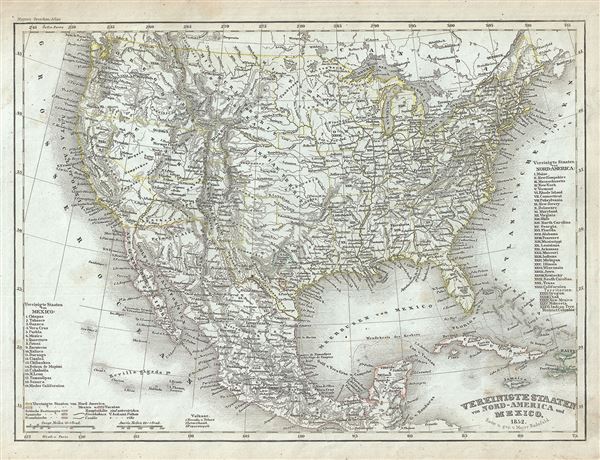
This is a small format Joseph Meyer 1852 map of the United States and Mexico at the height of the California Gold Rush and shortly after the annexation of Texas.
This map was issued at the height of the American westward expansion. Two years before this map was drawn, the California gold discovery of 1849 enticed thousands to embark upon the rigorous transcontinental emigration. Meanwhile, with the rise in territorial population to the west of the Mississippi, the eastern states were becoming increasingly divided over the issues of slavery and state vs. federal sovereignty. Within a few years these disputes would lead to the American Civil War.
A Closer Look
Coverage embraces the United States from Coast to coast and shows a very early configuration of the Transmississippi. Nebraska is represented at its fullest, extending from Kansas to the Canadian border. Montana, Wyoming, Idaho, Arizona, Colorado, West Virginia, and Nevada do not yet appear on the map. Shows the Mexico - U.S. Boundary line prior to the Gadsden Purchase.This map was issued at the height of the American westward expansion. Two years before this map was drawn, the California gold discovery of 1849 enticed thousands to embark upon the rigorous transcontinental emigration. Meanwhile, with the rise in territorial population to the west of the Mississippi, the eastern states were becoming increasingly divided over the issues of slavery and state vs. federal sovereignty. Within a few years these disputes would lead to the American Civil War.
Publication History and Census
This map was issued in Meyer's Zeitung Atlas. Dating maps from this atlas has always been difficult, especially if, as here, they are separated from the original volume. Few of the Zeitung maps are individually dated. Moreover, throughout its long publication history, the atlas title page and maps were regularly updated, while the imprint with the date was not, causing even further confusion.Cartographer
Joseph Meyer (May 9, 1796 - June 27, 1856) was a German industrialist, merchant, and publisher, active in Germany in the early to mid 19th century. He is best known for publishing the encyclopedia Meyers Conversation-Lexicon. Born in Gotha, Germany, Meyer was educated as a merchant in Frankfurt am Main. He moved to London in 1816, but returned to Germany in 1820 after his stock speculations and business adventures fell through. Once back in Germany, he began by investing in the textile trade (1820 - 24). Meyer began creating business plans concerning how to start railways soon after the first steam-hauled railway began operation in December 1835. He founded the Deutsche Eisenbahnschienen-Compangie auf Actien (German Railway Rail joint stock company) in 1845. Meyer also found great success as a publisher, utilizing the system of serial subscriptions to publications, a new idea for the time. He founded a company, Bibliographisches Institut in Gotha in 1825, which published several versions of the Bible, works of classical literature, atlases, the world in pictures on steel engravings, and an encyclopedia. He moved the Institut from Gotha to Hildburghausen in 1828. He published several atlases, including Meyer's Groẞer Hand-Atlas (1843 - 1860). In 1848, he supported the Springtime of the Peoples Revolutions that took place throughout Germany and much of Europe. When the revolutions failed in 1849, Meyer was briefly imprisoned for his support of revolutionary activities. The revolutions also began to take a toll on Meyer's business interests, and when he died, in 1856, the Bibliographisches Institut was struggling financially. His son, Herrmann Julius Meyer, took over the firm, spearheading a rapid recovery. This, and other businesses prospered under Herrmann Julius (April 4, 1826 - March 12, 1909) and when he died in 1909, he led the richest family in Saxony, with more total wealth than the King of Saxony More by this mapmaker...
Source
Meyer, J., Meyer's Zeitung Atlas, (Heidelberg: Bibliographischen Instituts) 1852.
Meyer's Zeitung Atlas, formally titled Neuster Zeitungs-Atlas Fuer Alte und Neue Erdkunde was a popular German hand-atlas published in Heidelberg by Joseph Meyer between, roughly, 1848 and 1859. The atlas is well engraved in the German style with exceptionally dense detail and minimal decoration. Meyer's Atlas, and its constituent maps, are typically very difficult to date as later editions often contain earlier maps and earlier editions later paste-in updates. That said, the atlas' frequent updates and publication run during a turbulent decade provide a noteworthy cartographic record of the period.
Condition
Very good. Minor toning and some foxing at places.