Digital Image: 1848 Streit Map of the United States of America, w/ Republic of Texas
VereinigtenStaaten-streit-1848_d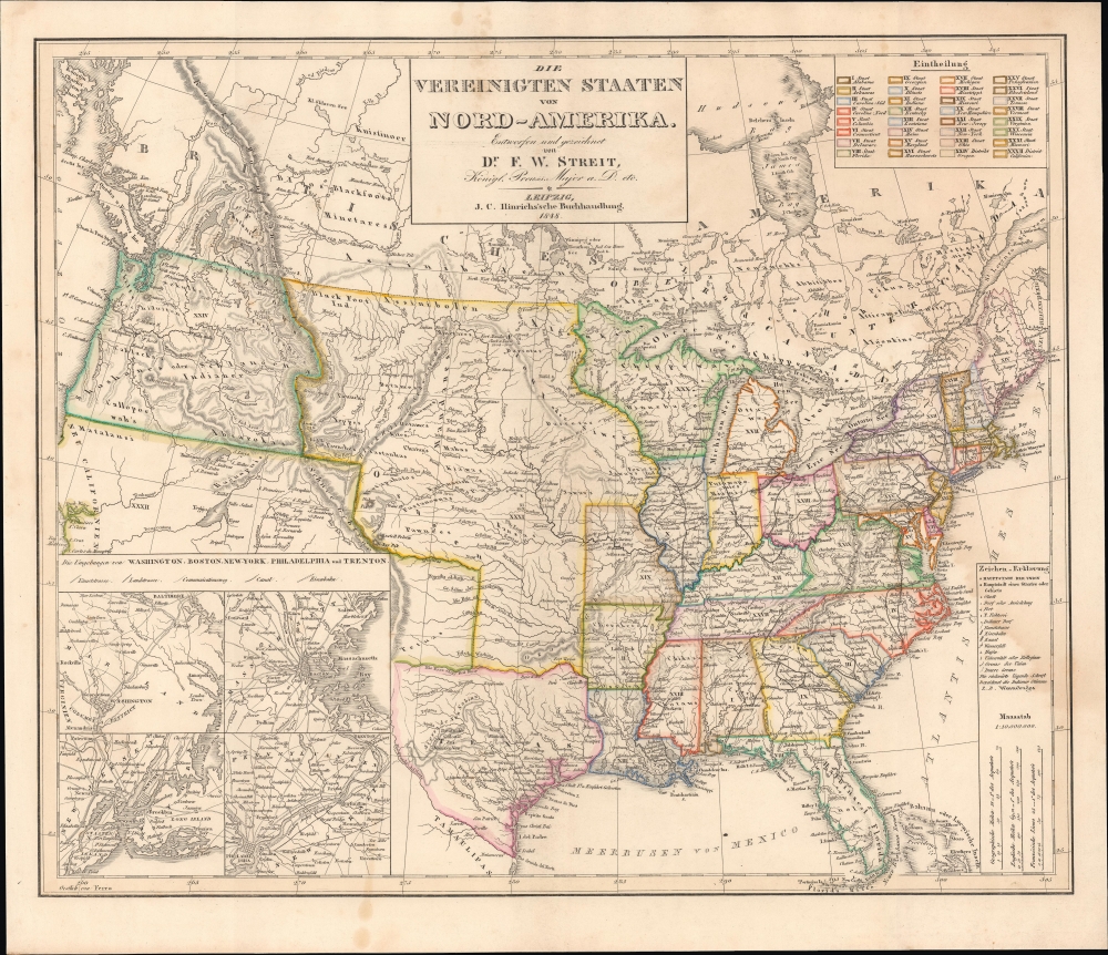

Title
Die Vereinigten Staaten von Nord-Amerika.
1848 (dated) 15.5 x 18.5 in (39.37 x 46.99 cm) 1 : 10000000
1848 (dated) 15.5 x 18.5 in (39.37 x 46.99 cm) 1 : 10000000
Description
FOR THE ORIGINAL ANTIQUE MAP, WITH HISTORICAL ANALYSIS, CLICK HERE.
Digital Map Information
Geographicus maintains an archive of high-resolution rare map scans. We scan our maps at 300 DPI or higher, with newer images being 600 DPI, (either TIFF or JPEG, depending on when the scan was done) which is most cases in suitable for enlargement and printing.
Delivery
Once you purchase our digital scan service, you will receive a download link via email - usually within seconds. Digital orders are delivered as ZIP files, an industry standard file compression protocol that any computer should be able to unpack. Some of our files are very large, and can take some time to download. Most files are saved into your computer's 'Downloads' folder. All delivery is electronic. No physical product is shipped.
Credit and Scope of Use
You can use your digial image any way you want! Our digital images are unrestricted by copyright and can be used, modified, and published freely. The textual description that accompanies the original antique map is not included in the sale of digital images and remains protected by copyright. That said, we put significant care and effort into scanning and editing these maps, and we’d appreciate a credit when possible. Should you wish to credit us, please use the following credit line:
Courtesy of Geographicus Rare Antique Maps (https://www.geographicus.com).
How Large Can I Print?
In general, at 300 DPI, you should at least be able to double the size of the actual image, more so with our 600 DPI images. So, if the original was 10 x 12 inches, you can print at 20 x 24 inches, without quality loss. If your display requirements can accommodate some loss in image quality, you can make it even larger. That being said, no quality of scan will allow you to blow up at 10 x 12 inch map to wall size without significant quality loss. For more information, it is best consult a printer or reprographics specialist.
Refunds
If the high resolution image you ordered is unavailable, we will fully refund your purchase. Otherwise, digital images scans are a service, not a tangible product, and cannot be returned or refunded once the download link is used.
Cartographer S
Friedrich Wilhelm Streit (January 29, 1772 - June 12, 1839) was a Prussian military officer, engineer, mathematician, and cartographer. Streit began his career as an artillery officer in the Prussian military, where he honed his mathematical and cartographic skills. After leaving military service at the rank of major, he became a member of the Akademie gemeinnütziger Wissenschaften zu Erfurt and Gesellschaft für Erdkunde, one of the leading Prussian geographical bodies of the day. From 1807 to 1817 he was director of the map department of the Geographisches Institut Weimar. Over the same period, he oversaw the 'Topographisch-militairische Charte von Teutschland,' an ambitious project to survey the entirety of Central Europe on a consistent medium scale (1:180000), resulting in over 200 maps and supplements. He also published textbooks on mathematics and an English-German dictionary. More by this mapmaker...
Johann Conrad Hinrichs (October 30, 1763 - September 22, 1813) was a German publisher and bookseller. Little is known of his early life. In 1796, Hinrichs became partners with August Leberecht Reinicke, who had founded a bookstore in Leipzig five years earlier. By 1801, Hinrichs ran the bookstore alone. Beginning in 1798, he published catalogs of all new published works in the past six months, an invaluable resource for the reading public. Hinrichs then moved into publishing books in the fields of travel literature, law, political science, and history. After his death, his business was run by his widow Christiane Wilhelmine Hinrichs, a sister of Reinicke, initially alone and from 1816 together with her nephew Christian Friedrich Adolf Rost, who became a partner in 1819, with the business publishing as 'J.C. Hinrichs'sche Buchhandlung.' It took on specialties in theology and Oriental Studies and survived into the 20th century. Learn More...
References
OCLC 694516923.