1945 Army Information Branch Newsmap Map of Japan
VolIVNo15F-newsmap-1945$400.00


Title
NEWSMAP for the Armed Forces. V-E Day + 12 Weeks - 189th Week of U.S. Participation in the War.
1945 (dated) 34.25 x 46.25 in (86.995 x 117.475 cm) 1 : 3168000
1945 (dated) 34.25 x 46.25 in (86.995 x 117.475 cm) 1 : 3168000
Description
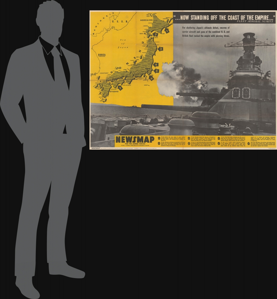
This is a 1945 Army Information Branch Newsmap propaganda map of Japan featuring a battleship engaged in firing towards the archipelago. Published during the last few months of World War II (1939 - 1945), this piece emphasizes efforts by the United States and Britain to force Imperial Japan to surrender.
A Closer Look
A black and white photograph of an American battleship dominates the sheet. Smoke billows from its guns and fire spews from the muzzles emphasizing the continued bombardment of Japan. A map of Japan occupies the upper left with dozens of cities identified. Tokyo, Yokohama, Nagoya, and Osaka are labeled in bold. Seven large arrows point to parts of the Japanese islands, indicating locations where American operations had taken place between July 10 and July 18. A key along the bottom provides short explanations of these actions, which include attacks by carrier-based aircraft, bombardments by the combined American and British fleet, and bombing raids by American B-29 Superfortresses.Verso Content: Photo History of Army Air Forces
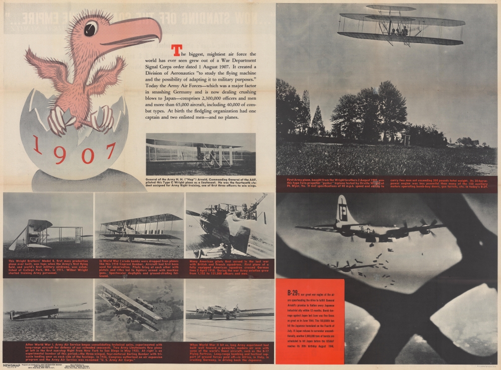
Utilizing nine photographs of different aircraft, the verso provides a short history of the evolution of the Army Air Forces from its creation in August 1907 to its present strength in July 1945. Wright flyers appear in three of the photos, while World War I (1914 - 1918) era planes occupy three of the others. World War II era aircraft appear in only two of the photos, these being the ultra-modern B-17 and B-29.Publication History and Census
This map was created and published by the Army Information Branch, appearing on Monday, July 30, 1945. We note nine examples cataloged in OCLC which are part of the collections at Denison University, Ohio Wesleyan University, Davidson College, the University of Michigan, the Library of Michigan, Southern Illinois University at Edwardsville, the University of Missouri - Columbia, Texas A and M University, and the Denver Public Library. An example is also part of the collection at the University of North Texas.Cartographer
The Army Orientation Branch (1940 - c. 1949) created special maps for teaching the Army Orientation Course and was based at The Pentagon in Washington, D.C. The Army Orientation Branch was part of the Information and Education Division. More by this mapmaker...
Source
NEWSMAP Series.
Newsmaps were published weekly between April 1942 and March 1946. Their content usually featured world maps, short summaries of the week’s military action, and photographs of troops and materiel. Early Newsmaps were printed on one side only, but, later in the war, they were printed on both sides, with the reverse bearing large-format maps, photographs, or other visual information. Several different versions of Newsmaps were produced: a large domestic version, a smaller overseas version, and an industrial version, which included more information about war production efforts. Two other editions appear in the United States Government Publications Monthly Catalogs, a 'Newsmap Special Edition' and a 'Newsmap Special Supplement for Special Training Units'.
Per the National Archives and Records Administration, ‘NEWSMAPS were not issued for general distribution. The posters were distributed to military installations, government and civilian groups working on War Department projects, and certain depository libraries, as designate by Congress, and one copy to Congressmen, if requested.’ The importance of the Newsmaps to the Army is related in the 1944 Basic Field Manual for The Special Service Company. The Manual states that as soon as the company reaches its destination ‘the company commander should contact the Special Service Branch in theater of operations headquarters, for copies of the weekly Newsmap.’ Also per the Manual
Per the National Archives and Records Administration, ‘NEWSMAPS were not issued for general distribution. The posters were distributed to military installations, government and civilian groups working on War Department projects, and certain depository libraries, as designate by Congress, and one copy to Congressmen, if requested.’ The importance of the Newsmaps to the Army is related in the 1944 Basic Field Manual for The Special Service Company. The Manual states that as soon as the company reaches its destination ‘the company commander should contact the Special Service Branch in theater of operations headquarters, for copies of the weekly Newsmap.’ Also per the Manual
The librarian should check the weekly Newsmap as soon as it is made available and should post it in a conspicuous place. He should take steps to see that the place where the Newsmap is posted is made known to all troops of the area in which the company or platoon is operating. This can be done effectively through notices in soldier newspapers, verbal announcements by those directly in charge of troops, and by posting announcements on bulletin boards.
Condition
Good. Light wear along original fold lines. Verso repairs to separations at fold intersections. Text and printed images on verso.
References
University of North Texas W 109.207:4/15. OCLC 47735386.