This item has been sold, but you can get on the Waitlist to be notified if another example becomes available, or purchase a digital scan.
1930 Bergelin Map of the World and French Voyages of Discovery
VoyagesDecouvertes-bergelin-1930$1,250.00


Title
Voyages des Découvertes et d'Explorations des Marins Français depuis le XVe. siècle.
1930 (dated) 31.5 x 50.75 in (80.01 x 128.905 cm)
1930 (dated) 31.5 x 50.75 in (80.01 x 128.905 cm)
Description
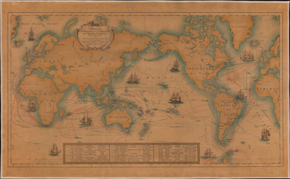
This is a 1930 L. Bergelin pictorial map of the world celebrating French voyages of discovery from 1402 to 1840. This map appeared at the end of the Années folles, a post-World War I period of rich social, artistic, and cultural innovation centered in Paris. It coincided with a resurgence of French national pride, much of which was expressed in novel new forms of art that combined advances in printing, the rise of propaganda imagery, and egalitarian social values.
A Closer Look
The map traces thirty-two voyages of discovery, each cataloged in a table along the bottom border. It provides the dates of voyages, names explorers and the ships involved (if they had names), and identifies destinations. Five additional voyages not represented on the map appear in the table. One such, the voyage of Chevalier de Grenier, was a point of mystery even to the cartographer. (Our cursory research has revealed that the Chevalier de Grenier undertook hydrographic work in the Indian Ocean in 1769 and supposedly determined the position of the Seychelles, Diego Garcia, and other islands.)Publication History and Census
This map was created and published by L. Bergelin in 1930 with a data provided by the Bibliothèque Nationale and the French Navy. We note a single cataloged example, located at the Bibliothèque Nationale de France.Cartographer
L. Bergelin (fl. c. 1930 - c. 1972) was a French cartographer active during the mid-20th century. He produced school wall maps, world maps, and city plans, notably of Paris. From 1838, he also worked on the Peugeot road atlas beginning. More by this mapmaker...
Condition
Very good. Devarnished and laid down on fresh linen.
References
Bibliothèque nationale de France, département Cartes et plans, GE C-5680.