Title
Hong Kong and the New Territories. Wan Ha.
1949 (dated)
25.25 x 34.5 in (64.135 x 87.63 cm)
1 : 20000
Description
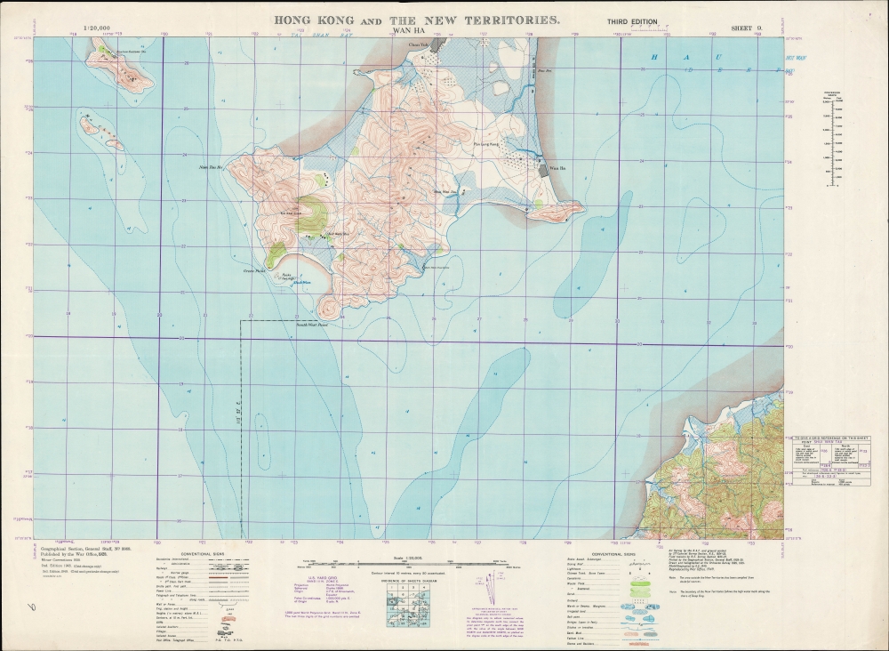
A fascinating and highly detailed 1949 War Office survey map of portions of today's Shenzhen Municipality (then Bao'an County) and the New Territories of Hong Kong. Specifically, it includes the southern half of Shenzhen's Nanshan District and a small part of Hong Kong's Yuen Long District. In recent years, a bridge, highway, and port facilities have made this area one of the main crossing points between Shenzhen and Hong Kong.
A Closer Look
Coverage includes the southern portion of today's Nanshan District (南山區) of Shenzhen Municipality in the People's Republic of China (mainland China). Information is indicated at a granular level of detail, down to individual fields, buildings, and foot paths. That being said, the War Office was careful to point out that the 'area outside of the New Territories [including most of the land and water seen here] has been compiled from dubious sources'. Though not a chart per se, fathoms, hazards, reefs, and other maritime features are also noted. The purple grid overlying the map corresponds to an idiosyncratic World Polyconic Projection using the U.S. Yard Grid system, developed for the 'Southwest Pacific' region during World War II by modifying a pre-existing British grid system.
The Sheh How Customs Station on the southeastern side of the peninsula is worth noting. In the 1930s - 1940s, though distracted by fighting a Communist revolution and a Japanese invasion, the Nanjing Government led by Chiang Kai-Shek invested considerable resources into controlling cross-border smuggling, with the border between Hong Kong and mainland China being one of their main areas of concern (for context, see Philip Thai's 2018 book China’s War on Smuggling: Law, Economic Life, and the Making of the Modern State, 1842 - 1965). The northernmost of the two islands at left is now called Dachan Island (大铲岛, here as Tai Shan) and hosted a customs station. The southernmost islands, here as Ma Chau, are now merged in a perfectly rectangular-shaped island still called Mazhou (孖洲, the Mandarin pronunciation of the characters).
As with Shenzhen as a whole, there have been dramatic changes to the landscape since the early 1980s due to land reclamation, urban development, and rechanneling of waterways into reservoirs. This area was historically known as Nantou / Nam Tau (南头) and the remains of an ancient city (consisting mostly of a stone gate) lie just to the north of the area seen here. Today it is known for hosting an aquatic-themed shopping mall called Sea World (no relation to the American amusement park of the same name) and has been recently earmarked for greater investment and development, with a new metro station opening in 2022.
At bottom-right is a portion of Yuen Long District in Hong Kong's New Territories. Yuen Long was connected to Shenzhen over the waters seen here by the Shenzhen Bay Bridge, the key piece of the Hong Kong–Shenzhen Western Corridor, opened in 2007. As the bridge crosses the maritime border between Hong Kong and Shenzhen, its construction and operation have been fairly complicated. To simplify matters (somewhat), the Shenzhen portion of the bridge was leased to the Hong Kong government and as a result Hong Kong traffic laws (driving on the left) apply on the entire span. The eastern side of the peninsula belonging to Nanshan District, Shenzhen has seen widespread land reclamation in recent decades for the bridge project, urban development, and extensive port, ferry, and customs facilities.Historical Context
This map was one part of a 24-sheet survey map series of Hong Kong, first undertaken in 1928 - 1930 and updated periodically thereafter. This ambitious undertaking was no doubt one of the largest, if not the largest, topographical surveys of Hong Kong at the time. The updates made after the Second World War (2nd and 3rd editions) were no doubt motivated by taking stock after the city's occupation by the Japanese. But the third edition in 1949 also coincides with the Communist revolution in mainland China, which presented a serious threat to the colony.
The United Kingdom was the earliest Western power to recognize the People's Republic of China, in January 1950, in a bid to protect Hong Kong. Still, it was not at all clear that Hong Kong would be safe from a Communist invasion, and Britain was hardly in a position to try to defend the colony at the time. We now know that part of the reason the Communists left Hong Kong alone is because it served a vital function as a window to the capitalist world, allowing, for instance, the evasion of a U.S. blockade to receive critical supplies during the Korean War. Though tens of thousands of refugees fled the mainland for Hong Kong in the late 1940s, the border between Hong Kong and 'red' China was quite open in the early-mid 1950s, allowing Hong Kong residents to travel to their home villages and visit relatives. Though this 'travel,' often an excuse for trading, was a thorn in the side of the Communists, who were attempting to institute a strict customs regime and control the flow of precious metals to support the renminbi, it also was an economic boon, especially to Guangdong and Fujian provinces.Publication History and Census
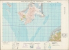
This map was initially produced by the British War Office in 1928 incorporating surveys undertaken by the Royal Air Force and Royal Engineers. Corrections were added in 1939, a second edition was issued in 1945, and this third edition appeared in 1949, with assistance from the Ordnance Survey (subsequent editions were produced in 1952, 1957, and 1969). This is the 9th Sheet in a series of 24 (a diagram of the full survey is included at bottom-center). The map is not independently cataloged with any institution in any edition, while the National Library of Australia holds the entire series consisting of various editions of the maps which are unclear from the catalog listing.
CartographerS
The British War Office (1857 - 1964) was a department of the British Government responsible for the administration of the Royal Army until 1964, when its functions were transferred to the Ministry of Defense. The War Office was to the Royal Army what the Admiralty was to the Royal Navy, and later, the Air Ministry. Within the War Office, the General Staff Topographical Section was responsible for thousands of maps issued for British intelligence and military use. The Topographical Section was renamed Geographical Section in April 1907. Many, once their military use passed, were offered through licensed agents to the general public. The sole London agent for War Office material was Edward Stanford. More by this mapmaker...
The British Ordnance Survey (1791 - present) is the national mapping agency of Great Britain and is one of the largest producers of maps in the world. This non-ministerial department of the government of the United Kingdom is responsible for producing maps of Great Britain and many of its overseas possessions. The history of the Ordnance Survey goes back as far as 1747, following the Jacobite rising, when King George II commissioned a comprehensive military survey of Scotland to assist further campaigns. The result, produced by Paul Sandby, John Mason and William Roy, was the Duke of Cumberland's Map, the first military quality map of the British Isles. This grew into the Principal Triangulation of Great Britain (1783-1853) under William Roy, and eventually lead to the creation of the Ordnance Survey in 1791. Today the Ordnance Survey produces a large variety of paper maps and digital mapping products. Its large scale maps, issued to the scale of 1:10000, available in sheet map form until the 1980s, are now only available digitally. All maps produced by the Ordnance Survey are in copyright for 50 years after publication. Learn More...
Condition
Very good. Minor creasing in the margins.