This item has been sold, but you can get on the Waitlist to be notified if another example becomes available, or purchase a digital scan.
1842 Wyld Map of the China Coast during the First Opium War
WarinChina-wyld-1842-2$1,000.00

Title
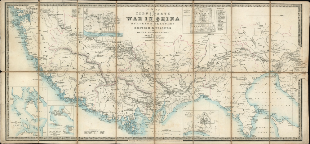
A Map to Illustrate the War in China compiled from Surveys and Sketches of British Oficers and Other Information.
1842 (dated) 13 x 28.5 in (33.02 x 72.39 cm) 1 : 3000000
1842 (dated) 13 x 28.5 in (33.02 x 72.39 cm) 1 : 3000000
Description
A rare 1842 separately issued thematic map published in London by James Wyld to illustrate the primary theater of the First Opium War (1839 - 1842). It was this war that resulted in the leasing of Hong Kong to the British. With an unusual east facing orientation, the map covers the coast of China from Canton (Guangzhou) and Macao (near modern day Hong Kong) as far north as Beijing, and inland as far as Nanjing (Nanking). Chinese provinces are highlighted in pink.
In 1839, the Daoguang Emperor, seeking to stem the tide of narcotic addiction in China, banned opium entirely and blockaded China’s only open trade port – Canton (modern day Guangzhou). They also seized and destroyed nearly 20,000 chests, roughly 1200 tons, of opium. Foreign traders within Canton were confined to their offices without access to outside food or supplies – essentially forcing them into a ‘capitulate or starve’ situation.
The British subsequently dispatched a naval and military force to China. The Royal Navy used its cannon power to inflict a series of decisive defeats on the Qing at various Chines ports, forcing them to the negotiating table - a tactic later referred to as ‘gunboat diplomacy.’ By 1842, when this map was drawn, the Qing were forced to sign the Treaty of Nanking, the first of the Unequal Treaties. The Treaty of Nanking created five open treaty ports and ceded Hong Kong to the British Empire. The Opium trade quickly resumed, but escalating tensions led to the Second Opium War (1856 - 1860) just 14 years later in 1856.
The First Opium War
The First Opium War, or the Anglo-Chinese War, (1839 - 1842) was a series of engagements fought between the United Kingdom and Qing China over trade and diplomatic relations. By the middle of the 19th century an enormous trade imbalance had developed between Europe and China due to high demand for Chinese goods (silk, porcelain, tea) in Europe and low demand for European goods (English wool anyone?) in China. To balance the trade, the British East India Company introduced Indian-grown opium to the Chinese market. The opium trade led to waves of addiction throughout China and reversed the trade imbalance within a couple of years.In 1839, the Daoguang Emperor, seeking to stem the tide of narcotic addiction in China, banned opium entirely and blockaded China’s only open trade port – Canton (modern day Guangzhou). They also seized and destroyed nearly 20,000 chests, roughly 1200 tons, of opium. Foreign traders within Canton were confined to their offices without access to outside food or supplies – essentially forcing them into a ‘capitulate or starve’ situation.
The British subsequently dispatched a naval and military force to China. The Royal Navy used its cannon power to inflict a series of decisive defeats on the Qing at various Chines ports, forcing them to the negotiating table - a tactic later referred to as ‘gunboat diplomacy.’ By 1842, when this map was drawn, the Qing were forced to sign the Treaty of Nanking, the first of the Unequal Treaties. The Treaty of Nanking created five open treaty ports and ceded Hong Kong to the British Empire. The Opium trade quickly resumed, but escalating tensions led to the Second Opium War (1856 - 1860) just 14 years later in 1856.
War and Trade
The First Opium War as essentially about trade, and so is this map. Throughout, Wyld offers a wealth of detail regarding trading and manufactories throughout China. He associates production with various towns and regions: Hoe-Tchou (India Ink), Nuing-Kouo (Paper), Kien-Tchang (Hemp and Rice), Nan-Tchang (Earthenware, Bricks, and Tiles), Ki-Ngan (blue Nankeen), etc. The map also notes Sugar Cane, Silk Worm, Organ, and Mulberry, Tallow, Camphor, and other plantations, in addition to mining regions and mineral deposits.Insets and Subplans
The map features five insets. These include:- Attack of Canton under the command of Sir Hugh Gough K.C.B., 25th May 1841
- Plan of the city of Ting-Hai in Chusan
- Plan of the city of Peking
- Attack on the Forts in the Canton River
- The Harbour and island of Amoy
Publication History and Census
This map was issued in several states. It first appeared in 1841, during the First Opium War. A second edition (the present example), with various updates, was issued in February of 1842. The OCLC identifies s subsequent revised 1846 edition. At the outset of the Second Opium War (1856 - 1860) another updated version of the map was issued, followed by a fourth edition published in 1860, towards the end of the war. The OCLC identifies holdings in various institutions but the map is extremely scarce to the market.Cartographer
Wyld (1823 - 1893) was a British publishing firm active throughout the 19th century. It was operated by James Wyld I (1790 - 1836) and his son James Wyld II (November 20, 1812 - 1887) were the principles of an English mapmaking dynasty active in London during much of the 19th century. The elder Wyld was a map publisher under William Faden (1749 - 1836) and did considerable work on the Ordinance Survey. On Faden's retirement in 1823, Wyld took over Faden's workshop, acquiring many of his plates. Wyld's work can often be distinguished from his son's maps through his imprint, which he signed as 'Successor to Faden'. Following in his father's footsteps, the younger Wyld joined the Royal Geographical Society in 1830 at the tender age of 18. When his father died in 1836, James Wyld II was prepared to fully take over and expand his father's considerable cartographic enterprise. Like his father and Faden, Wyld II held the title of official Geographer to the Crown, in this case, Queen Victoria. In 1852, he moved operations from William Faden's old office at Charing Cross East (1837 - 1852) to a new, larger space at 475 Strand. Wyld II also chose to remove Faden's name from all of his updated map plates. Wyld II continued to update and republish both his father's work and the work of William Faden well into the late 1880s. One of Wyld's most eccentric and notable achievements is his 1851 construction of a globe 19 meters (60 feet) in diameter in the heart of Leicester Square, London. In the 1840s, Wyld also embarked upon a political career, being elected to parliament in 1847 and again in 1857. He died in 1887 following a prolific and distinguished career. After Wyld II's death, the family business was briefly taken over by James John Cooper Wyld (1844 - 1907), his son, who ran it from 1887 to 1893 before selling the business to Edward Stanford. All three Wylds are notable for producing, in addition to their atlas maps, short-run maps expounding upon important historical events - illustrating history as it was happening - among them are maps related to the California Gold Rush, the New South Wales Gold Rush, the Scramble for Africa, the Oregon Question, and more. More by this mapmaker...
Condition
Very good. Dissected and mounted on linen.
References
OCLC 77547010. Library of Congress, Map Division, G7821.S4 1842 .W9.