This item has been sold, but you can get on the Waitlist to be notified if another example becomes available, or purchase a digital scan.
1940 Foster and Reynolds Map or Plan of Washington D.C.
Washington-reynolds-1940$75.00

Title
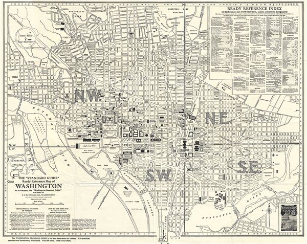
The 'Standard Guide' Ready Reference Map of Washington to accompany the 'Washington Standard Guide'.
1940 (dated) 19 x 24 in (48.26 x 60.96 cm) 1 : 16700
1940 (dated) 19 x 24 in (48.26 x 60.96 cm) 1 : 16700
Description
This is an appealing 1940 map or plan of Washington D.C. by the Foster and Reynolds Company of Washington. It covers Washington D.C. from the Arlington National Cemetery eastward as far as 28th Street and the Congressional Cemetery and from the Soldiers' Home Ground to the Anacostia River and the War College (southern tip of Washington D.C.). The map is exceptionally detailed, noting important buildings, monuments, streets, parks, railroads and an assortment of other topographical details.
The city is divided in four sections marked N.W., S.W., S.E. and N.E. from the Capitol Building. A Ready Reference Index' is set in the upper right quadrant. Two short paragraphs in the lower left quadrant detail the geographical divisions of streets and a note on how to use this map. This map was first copyrighted in 1904 and went through numerous subsequent editions. This is the revised 1940 edition. The map was published by the Foster and Reynolds Company, Washington D. C.
The city is divided in four sections marked N.W., S.W., S.E. and N.E. from the Capitol Building. A Ready Reference Index' is set in the upper right quadrant. Two short paragraphs in the lower left quadrant detail the geographical divisions of streets and a note on how to use this map. This map was first copyrighted in 1904 and went through numerous subsequent editions. This is the revised 1940 edition. The map was published by the Foster and Reynolds Company, Washington D. C.
Condition
Very good. Minor wear and creasing along original fold lines.