Title
The West Indies.
1799 (dated)
14 x 19 in (35.56 x 48.26 cm)
Description
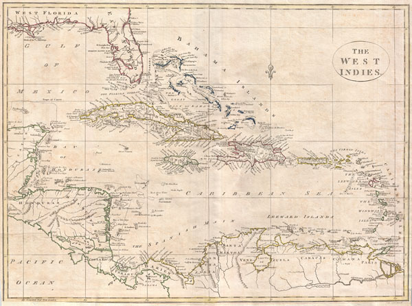
A fine 1799 map of the West Indies by the English mapmaker Clement Cruttwell. Shows what was then known as West and East Florida, along with the Bahamas Islands, Cuba, Jamaica, Domingo, and Puerto Rico (Porto Rico). Further southeast are the Virgin Islands, the Leeward and Windward Islands. The map also includes parts of Mexico, Honduras, Costa Rica, and the northern portion of South America. Cruttwell pays special attention to reefs, shoals, banks, and other underwater dangers, labeling many by name. He also makes note of the Spanish Main, the common term for A fine 1799 map of the West Indies by the English mapmaker Clement Cruttwell. Shows what was then known as West and East Florida (present day Florida, Alabama, and Louisiana), along with the Bahamas Islands, Cuba, Jamaica, Domingo, and Puerto Rico (Porto Rico). Further southeast are the Virgin Islands, the Leeward and Windward Islands. The map also includes parts of Mexico, Honduras, Costa Rica, and the northern portion of South America. Cruttwell pays special attention to reefs, shoals, banks, and other underwater dangers on this map, labeling many by name. Though generally quite accurate, there are a number of interesting errors. Charlotte Bay, Florida, he expands into a great inland Lagoon called Spiritu Santo. Lake Nicaragua is overly large and suggestive of a practicality of building a canal to the Pacific. He also makes note of the Spanish Main, mainland coast of the Spanish Empire around the Caribbean Sea and the Gulf of Mexico. The Spanish Main was the point of departure for enormous wealth that was shipped back to Spain in the form of gold, silver, gems, spices, hardwoods, hides and other riches; because of this, the area was ripe territory for pirates and privateers. Outline color and fine copper plate engraving in the minimalist English style prevalent in the late 18th and early 19th centuries. Mountains and topographical other detail shown by profile. Also makes note of rivers and shoals. Drawn by Clement Cruttwell and published in the 1799 Atlas to Cruttwell's Gazetteer. the mainland coast of the Spanish Empire around the Caribbean Sea and the Gulf of Mexico. The Spanish Main was the point of departure for enormous wealth that was shipped back to Spain in the form of gold, silver, gems, spices, hardwoods, hides and other riches; because of this, the area was ripe territory for pirates and privateers. Outline color and fine copper plate engraving in the minimalist English style prevalent in the late 18th and early 19th centuries. Mountains and topographical other detail shown by profile. Also makes note of rivers and shoals. Drawn by Clement Cruttwell and published in the 1799 Atlas to Cruttwell's Gazetteer.
Cartographer
Clement Cruttwell (1743 - August 5, 1808) was an English book and map publisher active in Bath and London in the late 18th and early 19th century. Cruttwell was born the son of William Cruttwell, a gentleman of Wokingham, Berkshire, England. As a young man Cruttwell was educated to be an Anglican Reverend and consequently maintained a lifelong interest in religious matters. Throughout his life, he published a number of religious works and geographical gazetteers including several focused on the British Isles and one dedicated to France. Though little is known of Cruttwell today, he was highly regarded in his own time. In his obituary, a period publication, The Universal Magazine of Knowledge and Pleasure describes Cruttwell as
a gentleman whose various literary performances, for labour, extent, and utility, have rarely been equaled, and, when regarded as the productions of an unassisted valetudinarian, have perhaps never been surpassed.
Cruttwell was also a known correspondent of George Washington to whom he sent his own translation of the Holy Bible, which Washington kept in his personal library until his death.
More by this mapmaker...
Source
Cruttwell, C., Atlas to Cruttwell's Gazetteer, 1799.
Condition
Very good. Original centerfold. Platemark visible. Some offsetting. Moderate overall toning. Narrow right and left margins. Lower margin extended. Blank on verso.