1846 Mitchell Map of the West Indies (First Edition!)
WestIndies-mitchell-1846$350.00

Title
West Indies.
1846 (dated 1834) 12.5 x 15.5 in (31.75 x 39.37 cm) 1 : 7500000
1846 (dated 1834) 12.5 x 15.5 in (31.75 x 39.37 cm) 1 : 7500000
Description
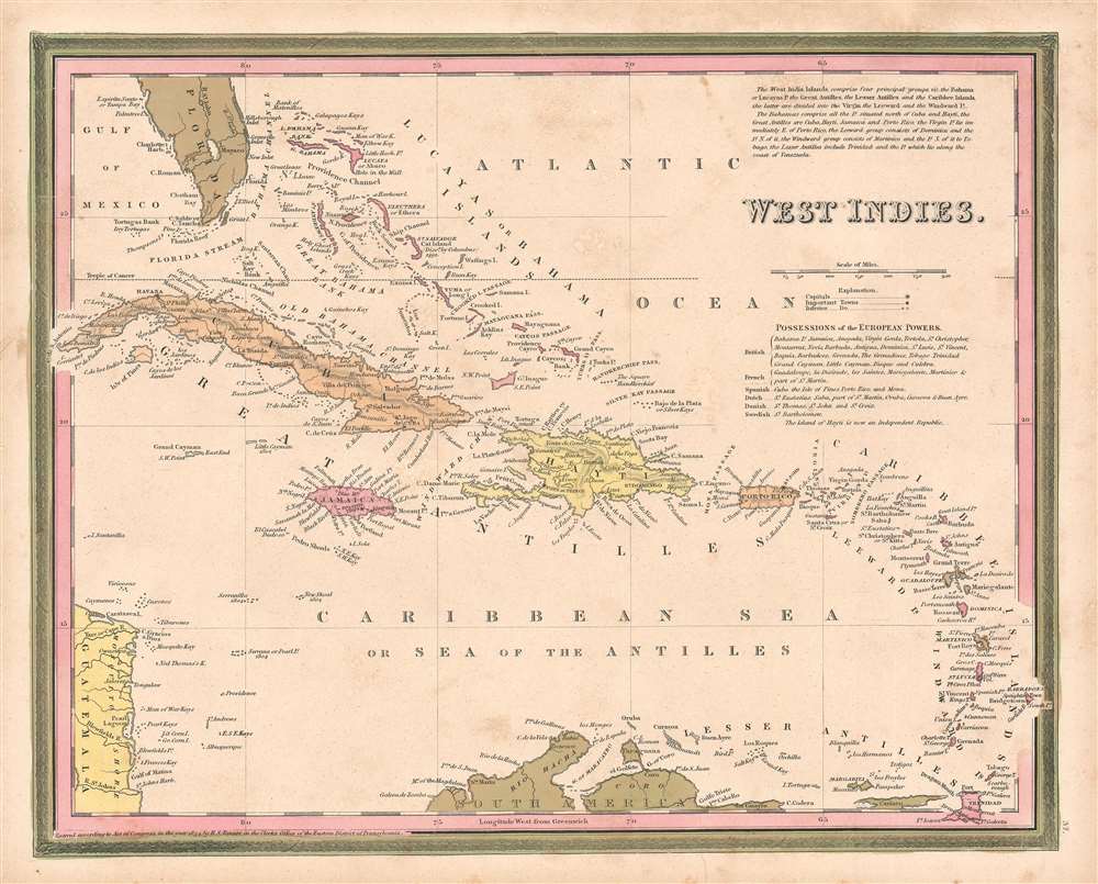
This is a first edition 1846 Samuel Augustus Mitchell map of the West Indies. The map depicts the region from Florida and the Bahamas to northern part of South America and from Guatemala and western Cuba to the 'Caribee Islands,' the Winward and Leeward Islands. Each individual island is identified, and cities and towns are labeled throughout. Points, bays, and other coastal features are also labeled. A list just below the scale entitled 'possessions of the European Powers' groups the islands together by whichever colonial power 'possessed' them at the time. It does note, however, the Haiti was an independent republic. The whole is engraved and colored in Mitchell's distinctive style with green border work and vivid pastels.
Publication History
This map was published by Mitchell in the 1846 edition of his New Universal Atlas. This is the only edition to bear the Tanner copyright imprint in the lower left corner. It would be removed for the second edition of Mitchell's atlas which was published later in 1846.Cartographer
Samuel Augustus Mitchell (March 20, 1792 - December 20, 1868) began his map publishing career in the early 1830s. Mitchell was born in Bristol, Connecticut. He relocated to Philadelphia in 1821. Having worked as a school teacher and a geographical writer, Mitchell was frustrated with the low quality and inaccuracy of school texts of the period. His first maps were an attempt to rectify this problem. In the next 20 years Mitchell would become the most prominent American map publisher of the mid-19th century. Mitchell worked with prominent engravers J. H. Young, H. S. Tanner, and H. N. Burroughs before attaining the full copyright on his maps in 1847. In 1849 Mitchell either partnered with or sold his plates to Thomas, Cowperthwait and Company who continued to publish the Mitchell's Universal Atlas. By about 1856 most of the Mitchell plates and copyrights were acquired by Charles Desilver who continued to publish the maps, many with modified borders and color schemes, until Mitchell's son, Samuel Augustus Mitchell Junior, entered the picture. In 1859, S.A. Mitchell Jr. purchased most of the plates back from Desilver and introduced his own floral motif border. From 1860 on, he published his own editions of the New General Atlas. The younger Mitchell became as prominent as his father, publishing maps and atlases until 1887, when most of the copyrights were again sold and the Mitchell firm closed its doors for the final time. More by this mapmaker...
Source
Mitchell, S.A., A New Universal Atlas Containing Maps of the various Empires, Kindoms, States, and Republics of the World…(Philadelphia: Mitchell) 1846.
The New Universal Atlas is one of the great American atlases of the mid-19th century. Samuel Augustus Mitchell first issued the atlas in 1846 when he acquired the map plates and copyright for Tanner's New Universal Atlas from its publisher, Carey and Hart. The first transitional 1846 edition was published jointly with Carey and Hart, but a second edition was published in the same year with the Tanner imprint erased. This edition of the atlas also introduced the signature S. A. Mitchell green and pink color scheme. Most of the maps from the early editions of the atlas were engraved by H. N. Burroughs or C. S. Williams, often bearing their copyright. Burroughs maps also tended to have what map collector David Rumsey refers to as the 'Cary and Hart' borders, which featured a narrow vine motif. These borders were replaced, along with the Burroughs imprint, with the more traditional Mitchell strap work border used in the atlases until 1856. Mitchell published editions until late in 1850, when he sold the rights to Thomas, Cowperthwait and Company of Philadelphia. Under Cowperthwait, the atlases continued to be published and bear the Mitchell name until 1856, when the plates were again sold, this time to Charles Desilver. Desilver reworked the plates with new border art and a revised color scheme in the style of J. H. Colton. Desilver issued editions from 1857 to 1860, when the atlas was phased out in favor of Samuel Augustus Mitchell Jr.'s New General Atlas.
Condition
Very good. Minor foxing and toning. Light soiling. Blank on verso.