This item has been sold, but you can get on the Waitlist to be notified if another example becomes available, or purchase a digital scan.
1787 Bonne Map of the Western Roman Empire
WesternRomanEmpire-bonne-1787$62.50

Title
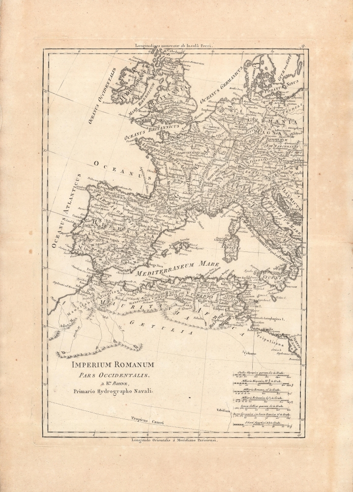
Imperium Romanum Pars Occidentalis.
1787 (undated) 14.25 x 9.5 in (36.195 x 24.13 cm) 1 : 11000000
1787 (undated) 14.25 x 9.5 in (36.195 x 24.13 cm) 1 : 11000000
Description
A detailed map of the Western Roman Empire by Rigobert Bonne, published c. 1787 in Bonne and Nicolas Desmarest's Atlas Encyclopedique. It provides a useful reference for students of the ancient world, reflecting considerable research as well as technical skill with the engraving.
A Closer Look
Western and central Europe along with the western half of North Africa are displayed, with modern cartographic knowledge providing a canvas for information about the ancient world. Latin names from Roman times for cities, towns, regions, mountain ranges, rivers, seas, islands, and other features are noted in great detail. Both the Ferro and Paris Meridians are employed, and a range of ancient and contemporary scales are included at bottom-right.Publication History and Census
This map was made by Rigobert Bonne and appeared as map No. 9 in Volume 1 of Bonne and Nicolas Desmarest's Atlas Encyclopedique, a very successful atlas that went through several editions in the late 18th century. The map is only independently cataloged among the holdings of the Bayerische Staatsbibliothek, Universitätsbibliothek Eichstätt-Ingolstadt, and Biblioteka Uniwersytecka w Kielcach, while the entire Atlas Encyclopedique is more widely distributed among universities and research institutions.Cartographer
Rigobert Bonne (October 6, 1727 - September 2, 1794) was one of the most important French cartographers of the late 18th century. Bonne was born in Ardennes à Raucourt, France. He taught himself mathematics and by eighteen was a working engineer. During the War of the Austrian Succession (1740 - 1748) he served as a military engineer at Berg-op-Zoom. It the subsequent years Bonne became one of the most respected masters of mathematics, physics, and geography in Paris. In 1773, Bonne succeeded Jacques-Nicolas Bellin as Royal Cartographer to France in the office of the Hydrographer at the Depôt de la Marine. Working in his official capacity, Bonne compiled some of the most detailed and accurate maps of the period - most on an equal-area projection known erroneously as the 'Bonne Projection.' Bonne's work represents an important step in the evolution of the cartographic ideology away from the decorative work of the 17th and early 18th century towards a more scientific and practical aesthetic. While mostly focusing on coastal regions, the work of Bonne is highly regarded for its detail, historical importance, and overall aesthetic appeal. Bonne died of edema in 1794, but his son Charles-Marie Rigobert Bonne continued to publish his work well after his death. More by this mapmaker...
Source
Bonne, Rigobert and Desmarest, N., Atlas encyclopédique contenant la géographie ancienne, et quelques cartes sur la géographie du moyen age, la geographie moderne, et les cartes relatives a la géographie physique, (Paris) 1787-1788.
Condition
Good. Uneven toning and spots of discoloration in margins. Crease along centerfold towards right.
References
OCLC 751058308, 633590206, 643715469.