1952 Glaubke Wild Bill Hickok Pictorial Treasure Map of the United States
WildBillTreasureMap-glaubke-1952-2$400.00


Title
Wild Bill Hickok Treasure Map.
1952 (dated) 23.75 x 35.25 in (60.325 x 89.535 cm) 1 : 5850000
1952 (dated) 23.75 x 35.25 in (60.325 x 89.535 cm) 1 : 5850000
Description
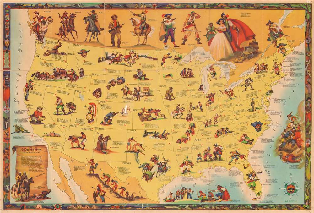
This is a 1952 Robert Glaubke pictorial map of the United States highlighting buried treasure. Small red 'X's mark the spots where buried treasure is presumed to be hidden. Wealth amassed by Spanish priests, Caribbean pirates, frontier miners, and Old West bandits is said to be hidden away anywhere from Los Angeles to the the high plains and the deserts of the American Southwest. Each location is accompanied by a sentence or two discussing the treasure is said to be buried there and, if it is known, how much wealth (usually gold) is purportedly waiting to be unearthed by the lucky and intrepid. Vignettes decorate the map, many which are violent clashes between Indians and the original bearer of the buried treasure. Large portraits of a plains Indian, a desperado, a bandit, and a conquistador, among others, line the top of the map. The whole is surrounded by a decorative border filled with the iconography of the Old West and the heyday of Caribbean Piracy.
Publication History and Census
This map was drawn by Robert Glaubke and the information about the buried treasure was compiled and edited by Thomas Penfield. The map was published by Rand McNally in 1952. We note two examples cataloged in OCLC, at the Wisconsin Historical Society and the Bibliothèque nationale de France. A third example is part of the David Rumsey Map Collection.CartographerS
Robert Glaubke (fl. c. 1935 - 1970) was an American artist and illustrator. Glaubke lived in Chicago for most of his life and gained the nickname 'Hemingway of the paint brush'. He served as a combat artist in the South Pacific with the U.S. Marines during World War II. Glaubke drew inspiration from his experiences in World War II and from everyday life. On one trip to Mexico, he lived among peasants and returned with seventy-five painting and hundreds of slide films. Glaubke gained a reputation for authentic research and absolute truth in his work, which led him to be in demand by educational publishers. Over time he developed a specialty in adventure and wild life illustrations, and was also hired by Rand McNally to work on several pictorial maps. He graduated from the Chicago Academy of Fine Arts. More by this mapmaker...
Thomas Penfield (fl. c. 1955 - 1990) was an American author and treasure hunter. He wrote several books revolving around lost and hidden American treasure troves, including Lost Treasure Trails, Dig Here!, Western Sheriffs and Marshals, and Around the World with the Fighting Yanks. He graduated from the University of Nebraska. Learn More...
Rand, McNally and Co. (fl. 1856 - present) is an American publisher of maps, atlases and globes. The company was founded in 1856 when William H. Rand, a native of Quincy, Massachusetts, opened a print shop in Chicago. Rand hired the recent Irish immigrant Andrew McNally to assist in the shop giving him a wage of 9 USD per week. The duo landed several important contracts, including the Tribune's (later renamed the Chicago Tribune) printing operation. In 1872, Rand McNally produced its first map, a railroad guide, using a new cost effective printing technique known as wax process engraving. As Chicago developed as a railway hub, the Rand firm, now incorporated as Rand McNally, began producing a wide array of railroad maps and guides. Over time, the firm expanded into atlases, globes, educational material, and general literature. By embracing the wax engraving process, Rand McNally was able to dominate the map and atlas market, pushing more traditional American lithographic publishers like Colton, Johnson, and Mitchell out of business. Eventually Rand McNally opened an annex office in New York City headed by Caleb S. Hammond, whose name is today synonymous with maps and atlases, and who later started his own map company, C. S. Hammond & Co. Both firms remain in business. Learn More...
Condition
Good. Verso repairs to fold separations. Slight loss at some fold intersections. Closed margin tears professionally repaired on verso. Pinholing in corners. Spot of white out in Colorado.
References
Rumsey 9527.000. OCLC 856903117, 494690020.